Sebastian and I took a ride out to Rhododendron Lake yesterday to see if we could find the far shore. Every time we get out to Rhodo Lake, we look across to the other side which appears to offer much better fishing sites since the shoreline looks much wider. Sebastian had never ridden out that way, so it served a second purpose of familiarizing him with some of the excellent riding trails that we've discovered while exploring the area.
Here's the route:
(Blue Numbers)
1. Entered on the Doumont Trail
2. Left towards Boomerang Lake
3. Right on Boomerang's southern intersection, and right at the next one too
4. Right... joined the power lines trail
5. Right onto Okay Mountain valley road
6. Left towards Rhododendron Lake
7. Usual Rhodo location. Short hike to lake
8. Far side of the lake (See detail above and descriptions below)
9. Turn right off Englishman River Main onto Branch 142
10. Doubled back... New plan! Left Br. 142 and took Okay Lake Trail
11. The excellent descent towards Boomerang on one of my favourite local trails
12. A quick visit to the Boomerang fishing site
13. Back at the Doumont entrance.
(Detail: Green Numbers)
1. Searching for road into Rhodo Lake
2. Right turn... Very clear and obvious trail
3. Rocky trail with some mud pools at this time of year. The very final section was a bit more difficult to get up. We both spun out on a large boulder and both of us needed a push from behind to get out. Nothing too bad; we were out fairly quickly, but I might park the bike on the upper side of this rock next time. It's almost right at the fishing site.
Some perspective
There are more fishing spots on this side of the lake, although it's quite shallow off the shore in many of the fishing locations. There's one good casting spot that is visibly deeper than the others. I caught two small trout in this location. Sebastian was fishing off to the right where a long cast is needed to get out to a decent depth. There were many fish jumping directly ahead of him, so I'm thinking that would be a good bait fishing spot if you used a heavy enough weight to get far enough out. Definitely a good spot to try again, but a pretty useless spot if anyone beats you out there, (just like the other side).
A not-so-good stitched image made from my GPS photos. Gives a rough idea of how the lake looks on that side.
I decided to have another try at getting to Nanaimo Lakes Road using the "roads" (pfffhgh) leading towards Mt. Decosmos, (from the north). I tried attacking Nanaimo Lakes Road from trails to the east of today's route a few weeks ago, and I noticed there was another possible way in just up the power lines route that needed to be tried. Here's the route:
1. Entered via Doumont Trail
2. Turned right south of Boomerang Lake
3. Right at next intersection towards the power lines route
4. Onto the power lines route heading west
5. Trail leading towards Decosmos Mountain
6. The climb... Very old and overgrown trail... Turned back at ~790m
7. Okay Mt Valley towards Rhododendron Lake
8. Rhododendron Lake to take pics of rhodos!
9. Rain! alt route back towards 142 main
10. 142 main back to Doumont and civilization
The plan was to follow this pink route:
Left... Beginning the "Decosmos" trail.
It was a tall order and I really didn't expect to make it all the way, but I wanted to see what it looked like out there. The trail wasn't that bad for the most part: There was the odd rocky patch, but it was generally pretty easy to pick through it. It became difficult towards the end, not because of the climb, but the incredible overgrowth of alders on this pretty old disused logging road. I got pretty fed up of stopping to pull branches out of my way and as it began to thicken with small trees I eventually gave up the ghost. I'm still wondering how far you can get on this road though; there were occasional quad tracks leading through all that mess. I'll head back this summer and give it another go.
Mirkwood!
So, what now? I promised my mother-in-law that I would take some photos of the blooms on Rhodo Lake. Off I went! I came back down the hill and headed up the Okay Mountain valley towards Rhodo Lake.
It was beautiful at the lake today. Not a soul around for miles. I reached the lake, hiked in and took my photos:
180 degree panoramic of the lake
Some blooms are done already, but there are plenty about still
That was it... I took the alternate route back to Doumont along Englishman River Main to Branch 142. 72Km of logging roads altogether.
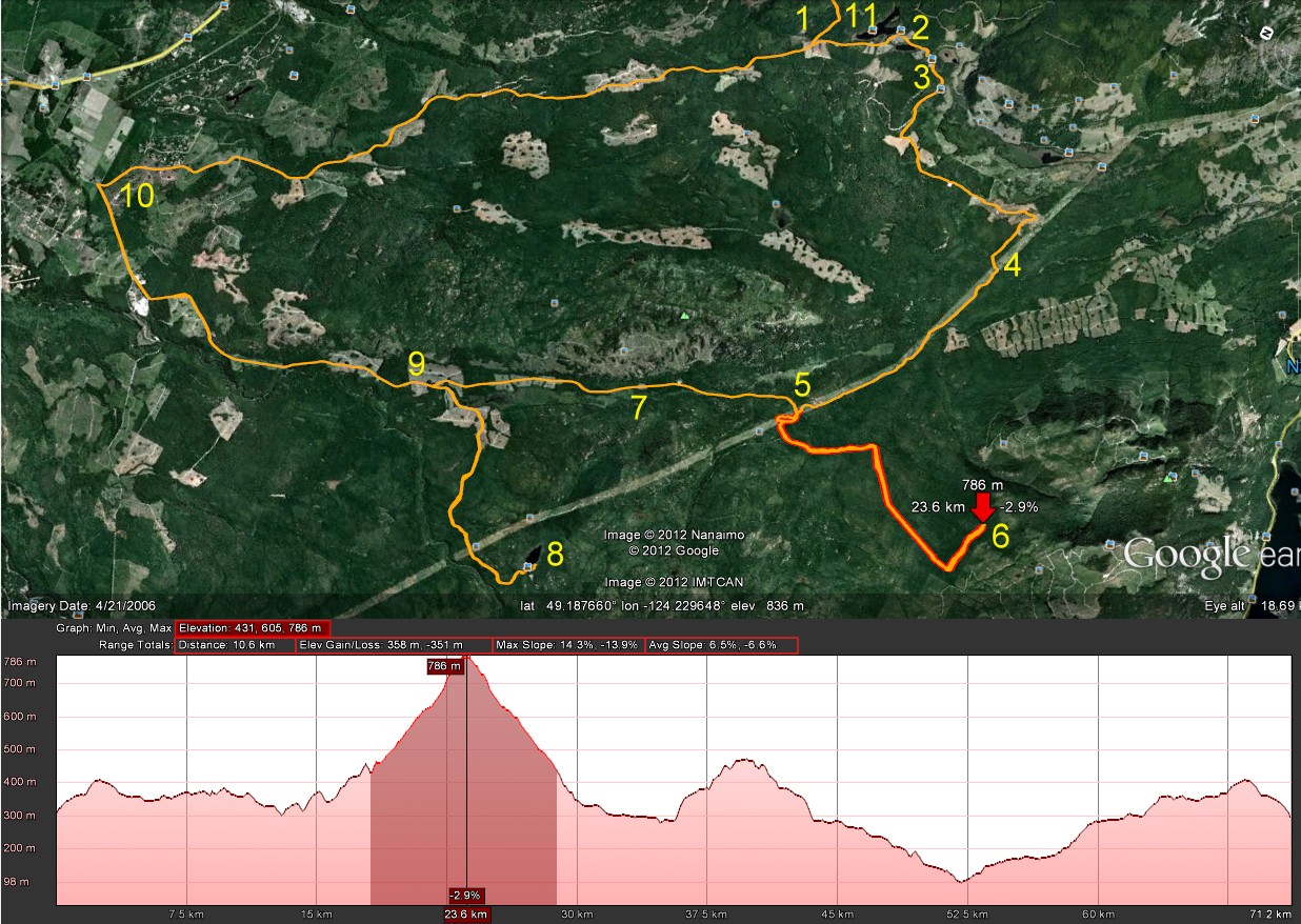
Beautiful day today, and since I got out of the dentist at a decent time, I decided to blast up Okay Mountain to check out the trail visible when passing through the valley on the way to Rhododendron Lake.
Here's today's route:
1. begin Doumont Trail 2.straight at Boomerang intersection (int B) 3. sharp right towards Okay Lk. 4. left up Okay Mt. 5. About face at 725m to retrace route, turning left to Branch 142. 6. Back to "int B" 7. left to the tank traps and Doumont Tr.
Some perspective.
Nerdy 3D view (Needs red/cyan glasses)
Elevation profile (entire ride, Doumont and back)
There was nobody out there today during the entire ride. I loved it! Silent everywhere. Okay Mountain's west trail is fantastic. A little overgrown here and there, but the views of Decosmos and the valley make it really worth picking through the odd fir tree and chunk of broom.
Broom covered trails
Looking NW towards Rhododendron Lake
A nicer grassy section of the trail (Facing NW)
Okay Valley facing almost due south. Mt. Decosmos far left
Looking down on the valley road to Rhodo Lake
Further along the trail. A clearer view of Decosmos is emerging.
Zoomed in
Really great ride!
-----------------------------------
June 03/2012 - A couple of added 3D anaglyph pics below. (You'll need red/cyan glasses):
I've been playing with Google Earth making 3D images of some of the more mountainous terrain. The results are quite surprising. The roads to the west of Fourth Lake look pretty hairy!
You'll need red/cyan glasses to view these. Red/green will work, but not that well.
I took the same route out to Rhododendron Lake today to meet up with Paul who was doing a bit of fishing.
29.1Km both ways
Beautiful lake! Lots of snags though. I'd like to try fishing with worms and a bobber here.
Great ride there and back. We saw a bit of rain at the lake side, but it passed quickly. Paul caught a very nice trout.
My mother-in-law asked me if I had taken any photos of the rhodos when I was out here last and so I took a few this time around. Looks like I'll need another trip to catch them in bloom during the summer. All of them are covered in tight buds right now. Here's a few shots:
I'm looking forward to heading back out there to catch the blooms.
Kudos to Paul for trying out the steep rocky section that leads back to Blackjack Ridge on a direct route from the lake. He reached the top and came down with no difficulty. Don't know how you came down so easily Paul. You're going to have to coach me on that one during the summer. Definitely too bloody steep for me when coming down.
To wrap things up, here's a cheesy time-lapse movie of the ride from Rhododendron Lake, through Okay Mt. valley, down the power lines toward Blackjack Ridge and then a left turn towards Boomerang Lake. I haven't solved the bumpy camera mount yet. Right now, my iPod is mounted near the headlight in a bum bag. :) It has to move up to my chest or helmet to settle the image down! This time-lapse shows nearly twenty minutes of footage in five minutes.
All rednecks should be given a free Government banjo so you can tell them from a distance!
Great solo ride today. Here's the map:
1-2 Doumont Trail, Tank Traps
2-3-4 Intersection B,C and D
4-5 Last week's new road find to the power line route
5-6 Right turn on untried trail that runs the back length of Okay Mountain
6-7 Excellent flat, smooth & fast road to Rhododendron Lake Road
7-8 Fishing at Rhododendron Lake
8-9 Attempted return through power line route direct
9-7 Follow same route back to Doumont
The 6-7 road is excellent and is the best route to Rhodo from the Doumont side. I didn't think it would work out that way when I set out today because my GPS map shows a large swampy area along the left side of this road. I was expecting some deep pools similar to the ones at the swampy area at the start of the power lines route. It was an amazing, well-groomed, flat road allowing speeds over 70km/h. The rest of the route to Rhodo Lake was a repeat of a ride last summer. Nice road into the lake although rockier than I remember.
The intersection where the Okay Mt. Valley road meets the road into Rhodo Lake. (Right sign is labeled "Rhododendron Lake")
180 Degree Panoramic of Rhododendron Lake
I fished for twenty minutes only today. There were a couple of nibbles, but it looked pretty dead... No rising fish at all. A group of idiots on the other side were firing rounds across the lake and I decided they weren't bright enough to know anything about gun safety and so I left. I passed several people arriving with beer cans in hand as I left which encouraged a further spurt of energy into my exit from the lake side. But back at my bike, I met the king of the local redneck population! (This is the gene-depleted man who needs the banjo as a warning sign to all who come in contact with him). Perhaps I'm a greater fool for even attempting to communicate with him. He told me that the power lines route was clear of snow now. "Yuh, I jus' bin up there in ma truuck and she's cleeeear awl the way thru." I took it hook, line and sinker.
The power line route from this end is extremely steep and rocky. I was well past my comfort level going up this road and the thought occurred to me that it would be a good deal harder coming down it. Good thing there's "no snow on the power line route."
The climb from a distance
I made it up in one piece, albeit a little sweatier than I was five minutes before. That was a ridiculous climb on large chunks of rock and I'm not sure I ever want to try it again! I sat at the top, recovered my senses for ten minutes and allowed some blood to flow back into my knuckles.
A small waterfall close to the top. Nice resting point!
The trail settles down at the top and begins to wind it's way toward the spot where Paul and I got stopped by snow a couple of weeks ago. I eventually met up with pretty deep snow at almost 700m and gave it my best shot, but it was pretty clear that I had to go back down that #@&!*% hill. I was 2km from our recent "stopped at snow" location on the other side.
I made it through this one, but it was getting pretty obvious that I was not going much further.
The ride back down was abominable and I was clearly out of my league here. I don't have the skill nor the agility to swing the rear end of my bike around to descend hills by fishtailing to cut the speed, and I'm not even sure it's possible to do so on rock chunks of this size. I began an extremely slow and gradual descent by using both brakes to literally inch my way down. At times it was nearly impossible for me to use the rear brake at all and a controlled skid from the front was all I had. Thanks Banjo Boy! What a relief it was to return to slopes where I felt in control. This was a good eye opener for me.
I returned along the same route through Okay Mountain's back valley and followed the power lines to the same roads I rode on the way out.
I didn't notice these large "inukshuk" style rock pilings the last time Paul and I took this road. I don't know who did it... Perhaps the logging company piled the rocks up while building the road. Formed by erosion? Naah.
Dog Turd Shaped Inukshuk
That's it. Great ride. I'm completely worn out.
Here's a Google Earth overview of the route to the lake from Doumont: