We're still hacking away at finding a shorter route to Nanaimo River Rd. that bypasses yellow logging gates. We have our current standard route, but it's close to being unusable as the winter and snow approaches. In addition, the standard route is quickly becoming unusable as young alders are growing so rapidly that the trail will soon be overgrown. (C'mon quads--we need you out there).
Paul and I decided to explore another possible route through from the "power lines trail" heading out towards the logging roads on Mt. DeCosmos. Google Earth shows a faint line that could have been a connector:
What a disappointment! The blue trail turned out to be a good road, old and well covered with deep moss with many alder saplings. Too bad that we didn't find the elusive trail... It was looking pretty good for a while, but the line visible on Google Earth must have been an old creek bed or a road so old that it's long gone.
Old moss covered roads (the sky blue line above)
Same sky blue road at the beginning of the grown-in alders. These became quite thick as we continued on this road.
We headed back to the main trail (orange) and revisited the route we had walked a few weeks ago that does lead to the DeCosmos roads, (shown here in red), but the rain has taken over and it's now a pretty steadily flowing creek over roots and well-sized boulders. This isn't a good alternative route, at least, not in the winter.
The flowing creek. It's do-able, but not a good regular route through.
So here's the next try. I don't know why we haven't tried this yet! I had it earmarked as a possibility some time ago, (I think Paul might have too), but as yet we haven't given this one a try. I'd like to give it a go next weekend if the rain cooperates:
We zipped out to Rhododendron Lake after we got skunked on our exploration. Paul pulled in this really nice cutthroat trout. Last cast, wouldn't you know it.
The catch piqued Paul's basic hunter instincts and the fish was devoured on the spot.
Parked just outside the "technical" trail to DeCosmos. It's a fun ride to here. Quads must be taking this route often to get through to DeCosmos: We saw a few logs jammed into holes here and there. Could you remove them once you're through so we don't break our necks on the bikes? ;)
I took off yesterday after work to see if I could find a route to Mt. Decosmos from the north east. That is, I want to get to the Decosmos mountain trail(s) without using Nanaimo Lakes Road, a main traffic route.
Here's yesterday's route:
1. West on Doumont Trail
2. At "Intersection D" turned right towards power lines trail(left goes to Blackjack Ridge).
3. Attempted what appeared to be a clear and easy route into the Decosmos area roads, but this trail terminates abruptly at the North Nanaimo River. Definitely no way through here. Might have been a bridge in place at one point.
4. Traveled towards Blackjack Ridge on "power lines trail" toward a second trail that appears to be heading in the Decosmos direction.
5. Superb narrow mud trail. Very green and very clear. A few pools to ride through, but nothing too problematic.
6. Trail stopped at the North Nanaimo River once again. The river is fast flowing and deep and can't be crossed easily.
6b. (Forgot to number this on my map) :) The small spur NE of 6 leads across a brook towards what appears on my gps maps as a small lake. Came to a dead end.
7. Tried two spurs in the hope that they might connect to the Decosmos Trail. No dice.
8. Connected with the familiar trail that runs the length of Blackjack ridge.
9. Went looking for Paul who I figured might be at Kidney Lake.
10. Back to Doumont.
Detail of location 6 from the image above. Interesting looking spot. I wonder if it's worth fishing here? The river moves rapidly through here, but there are spots where the action slows down and I'm guessing there are fish hanging about. Could be busy because it's easily accessible from the other side where a major logging road comes up directly from Nanaimo Lakes Road.
The trail entrance leading to location #3 (above). I thought this was a dead cert. I should have looked closer on Google Earth because it's pretty clear when you zoom right in that it doesn't go though.
North Nanaimo River looking west
End of the road at location #3
Next attempt at location #4: A right turn off the power lines trail heading off towards Decosmos. This trail was fun!
Pool on straight section before location #6. It's pretty fine sand and silt here. Gave me no problems coming in, but I sank deep enough to give the engine a good wash on the way back out.
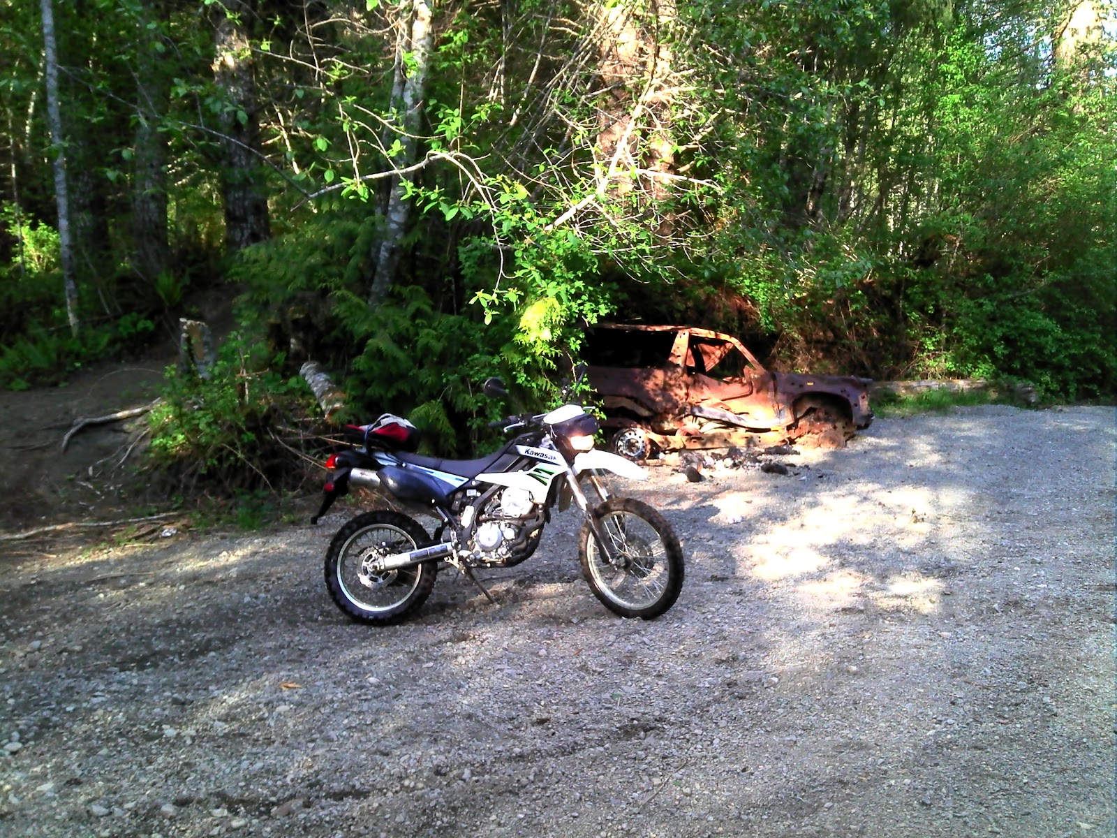
Old 4x4 wreck at location #6. Let this be a lesson to all of them!
Location #6 again. Parked at the North Nanaimo River. Nice spot.
Small brook (North Nanaimo River tributary) I crossed this to continue towards location #7 (and "6b")
One more small brook. I stopped here. This trail appeared to be going nowhere in particular and since I was still looking for a route towards Decosmos, I turned back. It's the dead end shown on the route above, NE of location #6. Map shows a small lake and Google Earth shows a nasty looking, boggy excuse for a lake.
128 degree panoramic of the North Nanaimo River. (low res. made from GPS photos)
That's it. Great 55.5Km ride. Must go back and try that river for trout.
I took the same route out to Rhododendron Lake today to meet up with Paul who was doing a bit of fishing.
29.1Km both ways
Beautiful lake! Lots of snags though. I'd like to try fishing with worms and a bobber here.
Great ride there and back. We saw a bit of rain at the lake side, but it passed quickly. Paul caught a very nice trout.
My mother-in-law asked me if I had taken any photos of the rhodos when I was out here last and so I took a few this time around. Looks like I'll need another trip to catch them in bloom during the summer. All of them are covered in tight buds right now. Here's a few shots:
I'm looking forward to heading back out there to catch the blooms.
Kudos to Paul for trying out the steep rocky section that leads back to Blackjack Ridge on a direct route from the lake. He reached the top and came down with no difficulty. Don't know how you came down so easily Paul. You're going to have to coach me on that one during the summer. Definitely too bloody steep for me when coming down.
To wrap things up, here's a cheesy time-lapse movie of the ride from Rhododendron Lake, through Okay Mt. valley, down the power lines toward Blackjack Ridge and then a left turn towards Boomerang Lake. I haven't solved the bumpy camera mount yet. Right now, my iPod is mounted near the headlight in a bum bag. :) It has to move up to my chest or helmet to settle the image down! This time-lapse shows nearly twenty minutes of footage in five minutes.
All rednecks should be given a free Government banjo so you can tell them from a distance!
Great solo ride today. Here's the map:
1-2 Doumont Trail, Tank Traps
2-3-4 Intersection B,C and D
4-5 Last week's new road find to the power line route
5-6 Right turn on untried trail that runs the back length of Okay Mountain
6-7 Excellent flat, smooth & fast road to Rhododendron Lake Road
7-8 Fishing at Rhododendron Lake
8-9 Attempted return through power line route direct
9-7 Follow same route back to Doumont
The 6-7 road is excellent and is the best route to Rhodo from the Doumont side. I didn't think it would work out that way when I set out today because my GPS map shows a large swampy area along the left side of this road. I was expecting some deep pools similar to the ones at the swampy area at the start of the power lines route. It was an amazing, well-groomed, flat road allowing speeds over 70km/h. The rest of the route to Rhodo Lake was a repeat of a ride last summer. Nice road into the lake although rockier than I remember.
The intersection where the Okay Mt. Valley road meets the road into Rhodo Lake. (Right sign is labeled "Rhododendron Lake")
180 Degree Panoramic of Rhododendron Lake
I fished for twenty minutes only today. There were a couple of nibbles, but it looked pretty dead... No rising fish at all. A group of idiots on the other side were firing rounds across the lake and I decided they weren't bright enough to know anything about gun safety and so I left. I passed several people arriving with beer cans in hand as I left which encouraged a further spurt of energy into my exit from the lake side. But back at my bike, I met the king of the local redneck population! (This is the gene-depleted man who needs the banjo as a warning sign to all who come in contact with him). Perhaps I'm a greater fool for even attempting to communicate with him. He told me that the power lines route was clear of snow now. "Yuh, I jus' bin up there in ma truuck and she's cleeeear awl the way thru." I took it hook, line and sinker.
The power line route from this end is extremely steep and rocky. I was well past my comfort level going up this road and the thought occurred to me that it would be a good deal harder coming down it. Good thing there's "no snow on the power line route."
The climb from a distance
I made it up in one piece, albeit a little sweatier than I was five minutes before. That was a ridiculous climb on large chunks of rock and I'm not sure I ever want to try it again! I sat at the top, recovered my senses for ten minutes and allowed some blood to flow back into my knuckles.
A small waterfall close to the top. Nice resting point!
The trail settles down at the top and begins to wind it's way toward the spot where Paul and I got stopped by snow a couple of weeks ago. I eventually met up with pretty deep snow at almost 700m and gave it my best shot, but it was pretty clear that I had to go back down that #@&!*% hill. I was 2km from our recent "stopped at snow" location on the other side.
I made it through this one, but it was getting pretty obvious that I was not going much further.
The ride back down was abominable and I was clearly out of my league here. I don't have the skill nor the agility to swing the rear end of my bike around to descend hills by fishtailing to cut the speed, and I'm not even sure it's possible to do so on rock chunks of this size. I began an extremely slow and gradual descent by using both brakes to literally inch my way down. At times it was nearly impossible for me to use the rear brake at all and a controlled skid from the front was all I had. Thanks Banjo Boy! What a relief it was to return to slopes where I felt in control. This was a good eye opener for me.
I returned along the same route through Okay Mountain's back valley and followed the power lines to the same roads I rode on the way out.
I didn't notice these large "inukshuk" style rock pilings the last time Paul and I took this road. I don't know who did it... Perhaps the logging company piled the rocks up while building the road. Formed by erosion? Naah.
Dog Turd Shaped Inukshuk
That's it. Great ride. I'm completely worn out.
Here's a Google Earth overview of the route to the lake from Doumont:
Took off with Paul last weekend to take a look at the disused gold mine on Mt. DeCosmos. There's still plenty of snow on the summit, but the mine is at pretty low altitude and we figured it would be easily reachable. We took the lower Blackjack Ridge logging road to Nanaimo Lakes Road and continued west towards the mine turn off. Surprise--the large gate was locked and blocked our entry towards Second Lake. (I knew there must be a reason $2 Hitler wasn't in his bunker as we entered the lakes area). I wish they'd at least put a sign up to let you know the area is locked-up before you motor all the way to the gate!
Anyway... a freshly concocted plan #2 seemed like a worthwhile venture: We decided to try getting beyond the deep pools on the power line route that leads from Blackjack Ridge to Rhododendron Lake.
The powerline route (yellow line from right to left). Elevation profile (l to r) represents the yellow line.
I tried to get through this road earlier but the pools of water were very deep back in December and many large problematic rocks were too difficult to see. It was much lower now and quite a bit easier to get through. The route stays mainly within the confines of the power line clearing and only leaves occasionally as the terrain demands. We crossed a few bridges, one of which had a really great river winding beneath.
Further on we came to a grinding stop when we discovered that the snow isn't quite done yet at 580m. We got off our bikes and walked on for a short distance just to confirm that there was little point in continuing and then made our way back along the same route. Here's a panoramic photo taken from a service clearing along the power lines. (View full size for the panoramic effect).
Two-thirds of the way back along the power lines, we crossed a newer logging road and decided to follow it. It was well worth it! It turned out to be a great trail, (cyan line), that lead back to the intersection that begins Blackjack Ridge's lower road. (I'm calling this "Intersection D" since I've slowly been creeping south with my intersection names, busily renaming everything I find as any good flag planting Brit should).
So that was it. Finished off with a bit of fishing at Boomerang Lake as a matter of course. It was a really good ride and I'm looking forward to doing the entire power line road in a month or so when the snow has gone completely.


