Paul and I took another overnight trip to Marcus lake a few days ago:
1. entered from the Doumont Road entrance
2. through the "tank traps" and stopped by bridge construction
3. returned and took alternate route to bypass "tank traps" (walked bike down steep bit like a big baby)
4. up branch 142 to 155 Main
5. left onto 155N and over ridge overlooking Mt. Moriarty
6. through small joiner trail giving access to roads heading south to N. River Road.
7. over the bridge leading to Fourth Lake
8. descending through mountain pass
9. stopped at a wider section of the Nitinat River (actually on return trip)
10. stopped at Nitinat River bridge (searching for, but not finding, Tuck Lake on day 2)
11. camping/fishing at Marcus Lake
A wider section of the Nitinat River (location #9)
The logging company's ridiculous trench digging, offering a greater challenge to recreational riders. I guess it keeps the trucks out or something. (#9)
Beautiful section of the Nitinat River near bridge at location #10
Nitinat River bridge (#10)
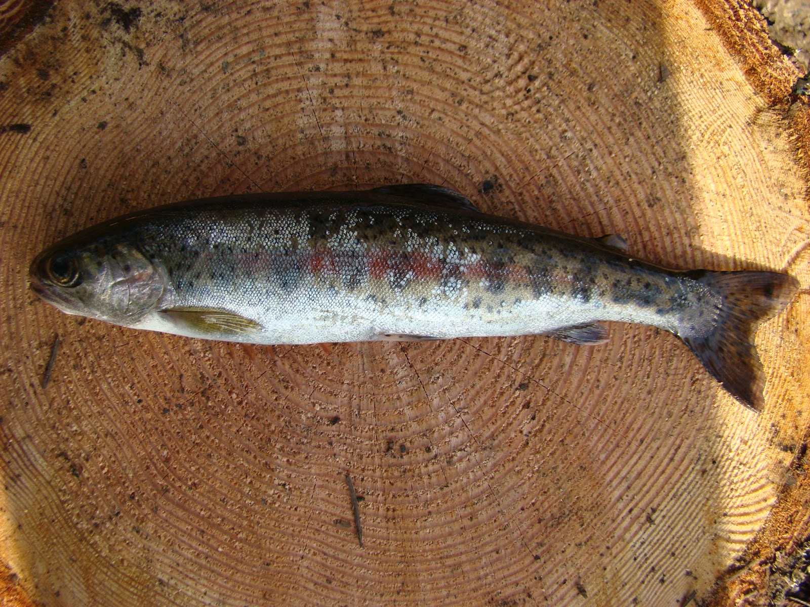
Great fishing at Marcus Lake, at least for Paul who limited out on both days. It was clearly very exciting for him! I managed to catch a couple. The trout have taken on a really interesting colour in this lake: Many are darker and display a thick red line along their sides. A few had a distinct copperish tone running their entire length... I thought it was interesting that Paul's lure copied this colouration quite closely. (I'm not sure if he agrees on this). He was using a small copper lure with a red flash. Must get one for this lake! Cannibalistic little @%#&'s they are!
Very dusty on the roads riding in the rear. I ended up trailing far behind for much of the riding, more to improve my view of the road surface than to reduce dust in my filter: It's irritating as hell hitting deep potholes that appear through the dust under your front tire. With that said, it was a terrific ride... I love the route though the pass below Fourth Lake. I can't believe it took us so long to start using this road.
Just a short local ride today. I left the house with the intention of fishing at a local no-name lake about 1km NE of Round Lake, (dubbed Dragonfly Lake by some of the more "flowery" local residents).
There were elk standing on opposite sides of the lake today. They called each other across the lake for the whole time I was there... excellent entertainment, and much better than the fishing as it happens! I bait fished there for about an hour, and after twiddling my thumbs and seeing no rising fish, I took off with a better plan in mind.
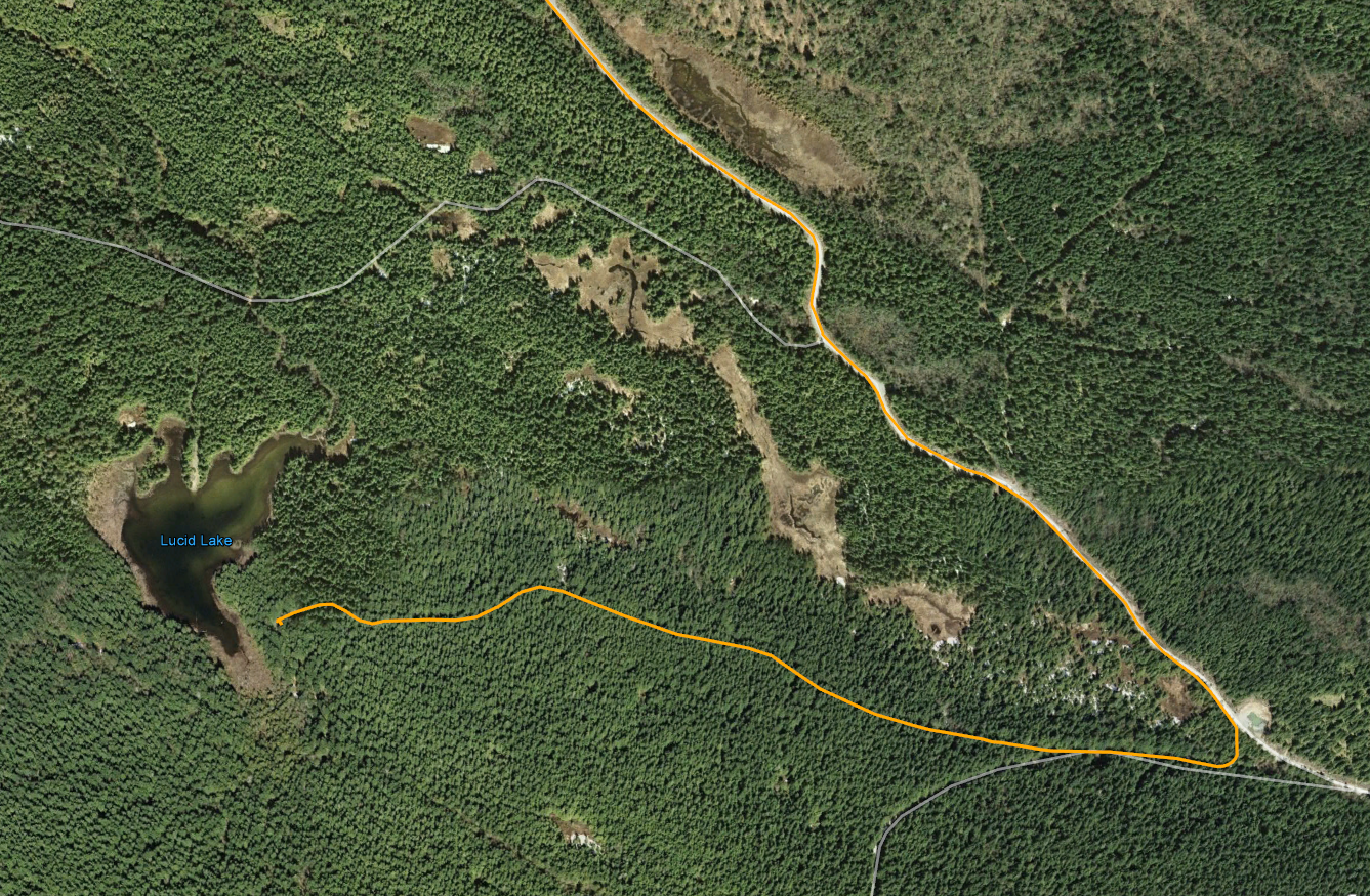
I thought it might be interesting to find the NE shore of Lucid Lake. Paul and I had watched a fisherman on the NE side of the lake when we visited the lake for the first time last year. Coming from Doumont Trail, continue past Boomerang Lake, keep left and follow the logging road that runs along the lower SW side of Mount Benson. Almost 10km past the lake turn right and keep right at the next Y. The trail opens up at the end to a large turn-around area with a fire pit at its centre. This is the best place to park and begin a short hike to the right to get to the lake shore. The trail does continue through a series of "tank trap" obstacles, but the trail eventually ends at a logged-out clearing some distance from the lake.
There must be a group of regular campers at this location: A small lean-to, fire pit and a tall frame designed for some special purpose are located a few metres from the lake shore. A small fishing peninsula has been built, or at least added to, to get a line further out into the lake. The lake's silty bottom looks relatively snag free except for the occasional weed here and there. There were fish rising here! Not many, but one alone was a 100% improvement on Dragonfly Lake.
It was late and there was no time to fish today, but this spot will make a good alternative for one of our local fishing spots.
I managed to convince myself that it was only the snow at higher elevations that prevented me from blasting over Blackjack Ridge towards Lucid Lake and Mt. Benson last fall. I had my memory corrected today while facing the familiar steep and boulder strewn logging road ahead of me. "I'm not going up THAT!" I'll leave this one for Paul to sail up.
Here's today's after work ride:
1. Entered at Doumont Trail
2. "Intersection A" Left toward Boomerang Lake
3. Continued straight past Boomerang on familiar "Behind Mt. Benson" road, but turned right shortly afterwards to begin the climb up Blackjack Ridge's upper road.
4. Made the same stop as last time, turning right onto a short spur road that offers amazing views at 711m. The Blackjack Ridge road begins a steep climb where this spur begins. I rode up it for about twenty feet and decided I had better leave this one for another day. (Maybe when/if I lower my bike????)
5. Turned right, on the way back, up this fantastic narrow windy trail that leads to the Benson Trail. Followed the Benson Trail back to Boomerang Lk. (Had a quick peep to see if Paul was fishing up the lake... Not).
6. Lake intersection
7. Dropped in at Kidney Lake and fished for an hour or so. Nice trout.
150° Panoramic - Mid way up the trail that heads up Blackjack Ridge. The trail directly behind my bike winds its way along the ridge and offers amazing views. I didn't ride it this time, but it's a great addition to the ride if you're looking for photos. That's Mt. Decosmos in the distance with Mt. Hooker on it's left. (First lake lies between them).
209° Panoramic - This is the end of the road at location #4. Mt Hooker (left) and Mt Decosmos in the Background. First Lake is clearly visible in this photo in the foreground of Mt. Hooker. (If you click on the photo).
In the distance lies Mt. Whymper. (Looking left of Mt. Hooker). Crappy name for the biggest mountain out that way!
First Lake - Mt Hooker (right) - Mt. Whymper (distant left)
The power lines. Good route to Rhododendron Lake
Tomorrow's lunch from Kidney Lake. Actually there were two, but the second one is embarrassingly small and received mundo face damage from being very greedy with my hook.
I took off yesterday after work to see if I could find a route to Mt. Decosmos from the north east. That is, I want to get to the Decosmos mountain trail(s) without using Nanaimo Lakes Road, a main traffic route.
Here's yesterday's route:
1. West on Doumont Trail
2. At "Intersection D" turned right towards power lines trail(left goes to Blackjack Ridge).
3. Attempted what appeared to be a clear and easy route into the Decosmos area roads, but this trail terminates abruptly at the North Nanaimo River. Definitely no way through here. Might have been a bridge in place at one point.
4. Traveled towards Blackjack Ridge on "power lines trail" toward a second trail that appears to be heading in the Decosmos direction.
5. Superb narrow mud trail. Very green and very clear. A few pools to ride through, but nothing too problematic.
6. Trail stopped at the North Nanaimo River once again. The river is fast flowing and deep and can't be crossed easily.
6b. (Forgot to number this on my map) :) The small spur NE of 6 leads across a brook towards what appears on my gps maps as a small lake. Came to a dead end.
7. Tried two spurs in the hope that they might connect to the Decosmos Trail. No dice.
8. Connected with the familiar trail that runs the length of Blackjack ridge.
9. Went looking for Paul who I figured might be at Kidney Lake.
10. Back to Doumont.
Detail of location 6 from the image above. Interesting looking spot. I wonder if it's worth fishing here? The river moves rapidly through here, but there are spots where the action slows down and I'm guessing there are fish hanging about. Could be busy because it's easily accessible from the other side where a major logging road comes up directly from Nanaimo Lakes Road.
The trail entrance leading to location #3 (above). I thought this was a dead cert. I should have looked closer on Google Earth because it's pretty clear when you zoom right in that it doesn't go though.
North Nanaimo River looking west
End of the road at location #3
Next attempt at location #4: A right turn off the power lines trail heading off towards Decosmos. This trail was fun!
Pool on straight section before location #6. It's pretty fine sand and silt here. Gave me no problems coming in, but I sank deep enough to give the engine a good wash on the way back out.
Old 4x4 wreck at location #6. Let this be a lesson to all of them!
Location #6 again. Parked at the North Nanaimo River. Nice spot.
Small brook (North Nanaimo River tributary) I crossed this to continue towards location #7 (and "6b")
One more small brook. I stopped here. This trail appeared to be going nowhere in particular and since I was still looking for a route towards Decosmos, I turned back. It's the dead end shown on the route above, NE of location #6. Map shows a small lake and Google Earth shows a nasty looking, boggy excuse for a lake.
128 degree panoramic of the North Nanaimo River. (low res. made from GPS photos)
That's it. Great 55.5Km ride. Must go back and try that river for trout.
Straight off to Kidney Lake at 4:00 today. The bite was on five minutes after I got there and it lasted for about twenty minutes, after which I fished an empty lake until 7:00. I rushed them in the door and Vicki had them in a buttery frying pan within ten minutes. There really is nothing like a fresh trout!
I took the same route out to Rhododendron Lake today to meet up with Paul who was doing a bit of fishing.
29.1Km both ways
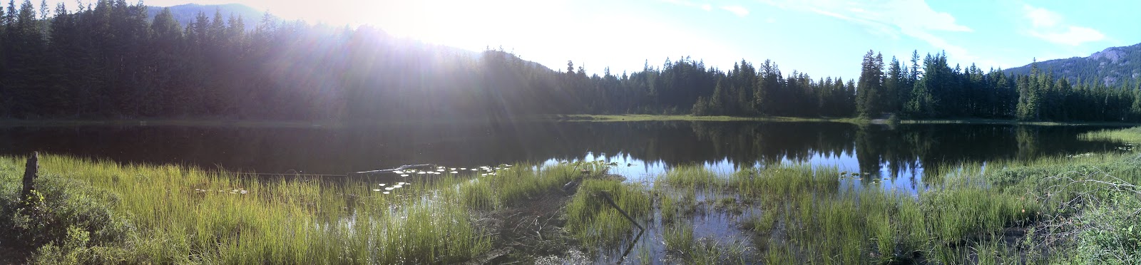
Beautiful lake! Lots of snags though. I'd like to try fishing with worms and a bobber here.
Great ride there and back. We saw a bit of rain at the lake side, but it passed quickly. Paul caught a very nice trout.
My mother-in-law asked me if I had taken any photos of the rhodos when I was out here last and so I took a few this time around. Looks like I'll need another trip to catch them in bloom during the summer. All of them are covered in tight buds right now. Here's a few shots:
I'm looking forward to heading back out there to catch the blooms.
Kudos to Paul for trying out the steep rocky section that leads back to Blackjack Ridge on a direct route from the lake. He reached the top and came down with no difficulty. Don't know how you came down so easily Paul. You're going to have to coach me on that one during the summer. Definitely too bloody steep for me when coming down.
To wrap things up, here's a cheesy time-lapse movie of the ride from Rhododendron Lake, through Okay Mt. valley, down the power lines toward Blackjack Ridge and then a left turn towards Boomerang Lake. I haven't solved the bumpy camera mount yet. Right now, my iPod is mounted near the headlight in a bum bag. :) It has to move up to my chest or helmet to settle the image down! This time-lapse shows nearly twenty minutes of footage in five minutes.
All rednecks should be given a free Government banjo so you can tell them from a distance!
Great solo ride today. Here's the map:
1-2 Doumont Trail, Tank Traps
2-3-4 Intersection B,C and D
4-5 Last week's new road find to the power line route
5-6 Right turn on untried trail that runs the back length of Okay Mountain
6-7 Excellent flat, smooth & fast road to Rhododendron Lake Road
7-8 Fishing at Rhododendron Lake
8-9 Attempted return through power line route direct
9-7 Follow same route back to Doumont
The 6-7 road is excellent and is the best route to Rhodo from the Doumont side. I didn't think it would work out that way when I set out today because my GPS map shows a large swampy area along the left side of this road. I was expecting some deep pools similar to the ones at the swampy area at the start of the power lines route. It was an amazing, well-groomed, flat road allowing speeds over 70km/h. The rest of the route to Rhodo Lake was a repeat of a ride last summer. Nice road into the lake although rockier than I remember.
The intersection where the Okay Mt. Valley road meets the road into Rhodo Lake. (Right sign is labeled "Rhododendron Lake")
180 Degree Panoramic of Rhododendron Lake
I fished for twenty minutes only today. There were a couple of nibbles, but it looked pretty dead... No rising fish at all. A group of idiots on the other side were firing rounds across the lake and I decided they weren't bright enough to know anything about gun safety and so I left. I passed several people arriving with beer cans in hand as I left which encouraged a further spurt of energy into my exit from the lake side. But back at my bike, I met the king of the local redneck population! (This is the gene-depleted man who needs the banjo as a warning sign to all who come in contact with him). Perhaps I'm a greater fool for even attempting to communicate with him. He told me that the power lines route was clear of snow now. "Yuh, I jus' bin up there in ma truuck and she's cleeeear awl the way thru." I took it hook, line and sinker.
The power line route from this end is extremely steep and rocky. I was well past my comfort level going up this road and the thought occurred to me that it would be a good deal harder coming down it. Good thing there's "no snow on the power line route."
The climb from a distance
I made it up in one piece, albeit a little sweatier than I was five minutes before. That was a ridiculous climb on large chunks of rock and I'm not sure I ever want to try it again! I sat at the top, recovered my senses for ten minutes and allowed some blood to flow back into my knuckles.
A small waterfall close to the top. Nice resting point!
The trail settles down at the top and begins to wind it's way toward the spot where Paul and I got stopped by snow a couple of weeks ago. I eventually met up with pretty deep snow at almost 700m and gave it my best shot, but it was pretty clear that I had to go back down that #@&!*% hill. I was 2km from our recent "stopped at snow" location on the other side.
I made it through this one, but it was getting pretty obvious that I was not going much further.
The ride back down was abominable and I was clearly out of my league here. I don't have the skill nor the agility to swing the rear end of my bike around to descend hills by fishtailing to cut the speed, and I'm not even sure it's possible to do so on rock chunks of this size. I began an extremely slow and gradual descent by using both brakes to literally inch my way down. At times it was nearly impossible for me to use the rear brake at all and a controlled skid from the front was all I had. Thanks Banjo Boy! What a relief it was to return to slopes where I felt in control. This was a good eye opener for me.
I returned along the same route through Okay Mountain's back valley and followed the power lines to the same roads I rode on the way out.
I didn't notice these large "inukshuk" style rock pilings the last time Paul and I took this road. I don't know who did it... Perhaps the logging company piled the rocks up while building the road. Formed by erosion? Naah.
Dog Turd Shaped Inukshuk
That's it. Great ride. I'm completely worn out.
Here's a Google Earth overview of the route to the lake from Doumont:
I zoomed out of work really quickly today so that I could get a few hours of fishing in at our local lakes and by 4:00 I had a line in the water at Kidney Lake.
It was a great ride down there: 1Km before the lake I heard a thunderous clatter to my left and made a mad scramble for a camera as a herd of 8 to 10 elk crossed the road right in front of me. They were pretty spooked by my bike and so they moved really quickly to conceal themselves in the trees to my right. I managed to get one shot off with my Garmin which was close at hand, but got nothing of the herd. So, off I went with my heart pumping about twice its normal rate only to meet a single female still looking for the herd. She gave me a bit more time and loped well ahead of my position so she could cross over to the other side. I captured her with the Garmin... Not a quality shot, but at least I got it! Totally thrilling watching them motor by like that!
Purple route from "Intersection A" (bottom right) to NE end of Kidney Lake.
Get out your magnifying glass! She's that clump of pixels near the centre!
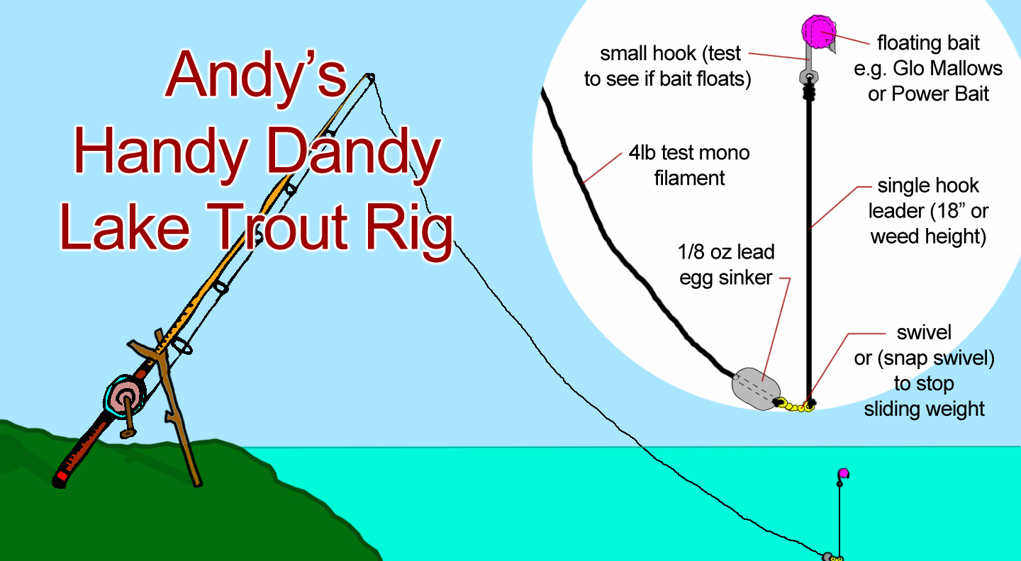
So, I got down to the lake and fished with some bait for a change. I set up "Andy's Handy Dandy Lake Trout Rig" which consists of an egg sinker (1/8lb lead weight that slides freely on the line), a swivel clip (which doubles as a stopper to keep the weight on) and an 18" leader attached to the swivel for floating bait. For bait I used yellow and orange scented Glo Mallows.
The beauty of this rig is that it allows the line to slide freely through the weight. That means that when the trout hits, it travels away with the line unimpeded by the weight and sets the hook when the slack is taken up. It's perfect for stocked trout that have a tendency to hit aggressively in this way. A small treble hook can be used also, providing it's small enough to be lifted by the bait (#14). Great for molding bait around with Power Bait. Also, leader length can be changed to match the weed height in any particular lake to keep the bait floating right at typical feeding height, (slightly above the weeds), for bottom swimming trout.
I fished that setup for about two hours without so much as a nibble today. There was lots of action on the surface by 6:00 and so I switched to spin casting my "Super Duper" favourite spinner. I caught the youngest and smallest trout in the lake with this. IT WAS DELICIOUS!!