
Showing posts with label fe390. Show all posts
Showing posts with label fe390. Show all posts
Friday, July 29, 2016
Slowest Is Sometimes Best
My life has been crazy for a while. Finally got out for a ride. Great afternoon in the foothills.
Tuesday, June 14, 2016
Saturday, November 14, 2015
Green Mountain, Except It Was White
 |
| Nearly 4000ft: Green Mountain aint so Green... |
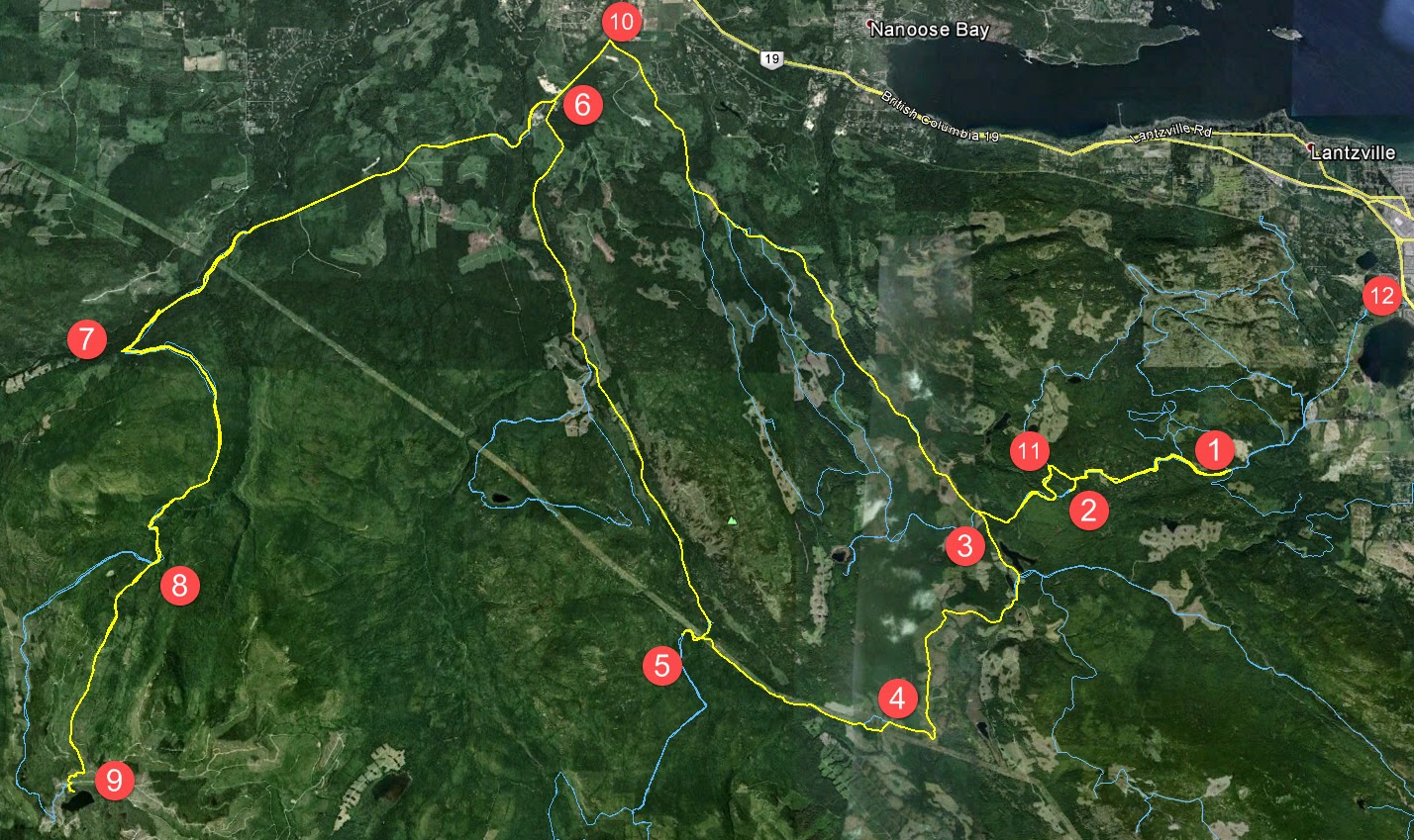
Ultimately, the best ride on Remembrance Day would have been up to pay our respects at one of the many WW2 era crash sites around here, perhaps visiting the Lockheed Ventura on Mt. Bolduc would have been more appropo. But with the shorter days and our later start, we decided Green Mountain from Doumont Road would be a better plan ~130km round trip.

Click to Enlarge.
1. Doumont Road Tank Traps
2. Left on to 142 and pass Boomerang L.
3. Right at Cottle L.
4. Right and follow Hydro Lines
5. Left after bridge. Left at Hickup Trail
6. Right onto NEW Escalator Trail (Easy). Turn Right as you pop out of the Escalator onto Decosmos/Deadhorse Creek Main (a major logging road).
7. Right at 2nd Lake onto Nanaimo Lakes Road
8. Left onto Branch K (Major Junction)
9. Left onto Green Mountain access road
10. Left
11. Beginning of Green Mountain Meadows and the Marmot Reserve.
 |
| Click to enlarge |
 |
| Elevation Track (m) |
Google Earth "Flyover" of the Route (Full Screen to View Text)
It was a great ride, offering a little of everything: some logging roads, technical single track, hill climbs and burms at Green Mountain, not to mention snow. The total distance was approximately 127km from Superstore Gas bar to Green Mountain and back to the Black Bear Pub. I've got to say the rear Mountain Motoz at 10psi was awesome everywhere, particularly up some serious grades in the snow. I didn't air it down to the 4 psi I usually roll on as we were hitting some potentially rim denting speeds on crush, and didn't fancy a pinch flat. Can't wait for a set of Tubliss...
 |
| White Trails Near Green Mt. Ski Hill |

Maybe the last picture of Andy with the trusty KLX250S. It's been an excellent ride for Andy, but the lack of torque and soft suspension are leaving him looking at Beta 300X Italian Princess. His money is down, and the beast should be here before too long. Can't wait to see it. Anyway, needless to say, we ended up at the Black Bear for a coupla delicious barley sandwiches. What a great way to finish a ride!
Checkout the short vid below for some trail condition samples...(Don't forget to change the settings to 1080P for the best resolution. - First shots with the Go Pro 4 Black. The quality looks much better...Pity about the music!)
Click here for a track from Wikiloc.
(Big "thank you" to Ross Collicutt, who provided the track we used to find our way up Green Mountain).
Thursday, May 21, 2015
Tuesday, April 21, 2015
Mud-Pluggin': Testing the DIY Camera Swivel Mount
Sunday, October 26, 2014
Down Baker Street to Moriarty's Lair
Our recent rides have been centered around using the excellent new roads created off 155 main by our friendly outdoors-sharing logging company. Paul and I took a round-about trip out that way today to see if we could navigate our newly-discovered trail that leads to Moriarty Lake, aptly named Baker Street, without running into TimberPest's gargantuan road blockage. We walked it during our previous ride in that area and decided that it was quite do-able if the weather remained dry. So we picked a nice soggy Sunday with lots of running water to attempt riding it. :) It was a terrific ride and a great success!
Here's the shape o' the day:
1. Entered the logging roads at Weigles Road/Doumont
2. Turned back at the "alternative tank traps" due to wind fall tree across the trail. We need a quader in here with a chainsaw!
3. Through the old tank traps, which is nicely cleared, and left turn on branch 142 towards Boomerang Lake.
4. Turned right and joined the power line trail.
5. Intended route towards the "hellevator" trail has turned into a pretty rapidly running river. We decided to head towards 155 main and blast up our recently more regular route.
6. Rode up Okay Mountain Valley, past the Rhododendron turning and turned left onto 155 main.
7. Uphill left turn onto signposted 155-160
8. Left onto connector trail to "Baker Street" (wikilocs track)
9. Through the connector and right down Baker Street to the logging roads surrounding Moriarty Lake. Took a quick visit to the Moriarty cabin where Paul was kind enough to share his British Rail type sandwich. Actually it was very good! (Yes it was - judging by the way you inhaled it! - P) Thanks mate.
10. Retraced route towards home. Dumped the bike up Baker Street. Darn you Moriarty! Followed 155 main up to a right turn onto branch 142
11. Back through the old tank traps.
12. Black Bear Pub for a pint o' IPA and ESB! Cheers!
Here's a direct track from doumont to Lake Moriarty. Use it in conjunction with this track of the connector (Baker St) to get right down to the lake. The track for the entire route, exactly as it appears on this blog page, can be found here.
Here's the shape o' the day:
1. Entered the logging roads at Weigles Road/Doumont
2. Turned back at the "alternative tank traps" due to wind fall tree across the trail. We need a quader in here with a chainsaw!
3. Through the old tank traps, which is nicely cleared, and left turn on branch 142 towards Boomerang Lake.
4. Turned right and joined the power line trail.
5. Intended route towards the "hellevator" trail has turned into a pretty rapidly running river. We decided to head towards 155 main and blast up our recently more regular route.
6. Rode up Okay Mountain Valley, past the Rhododendron turning and turned left onto 155 main.
7. Uphill left turn onto signposted 155-160
8. Left onto connector trail to "Baker Street" (wikilocs track)
9. Through the connector and right down Baker Street to the logging roads surrounding Moriarty Lake. Took a quick visit to the Moriarty cabin where Paul was kind enough to share his British Rail type sandwich. Actually it was very good! (Yes it was - judging by the way you inhaled it! - P) Thanks mate.
10. Retraced route towards home. Dumped the bike up Baker Street. Darn you Moriarty! Followed 155 main up to a right turn onto branch 142
11. Back through the old tank traps.
12. Black Bear Pub for a pint o' IPA and ESB! Cheers!
 |
| Wind Fall timber across the trail through the alternative tank traps (2 on map above) |
 |
| Colour Coded Altitude Track |
 |
| New burned out (stolen?) truck appears on route to the Tank Traps on the Doumont side (shortly before 2 on map) |
 |
| Washed out! River running down the route towards the HeLLeVaToR (5 on map) |
 |
| Approaching Moriarty Lake Cabin on foot |
 |
| Moriarty Lake Cabin at 9 |
 |
| Moriarty Lake Cabin at 9 |
 |
| Moriarty Lake Cabin at 9 |
 |
| Moriarty Lake Cabin at 9 Pack your garbage out...please |
Above: Real Time Vid of the "Highlights" of the route to Moriarty Lake.
Time Lapse: Turning off 155-160 onto connector leading to Moriarty Lake ("Baker Street")
Time Lapse: Back up Baker Street connector trail towards 155-160
Time Lapse: Return trip from 155
Track Flyover on Google Earth
GPS Track Playback at 100x Speed
Monday, September 15, 2014
Northwest Bay to Moriarty Lake and Beyond... (New Trail)
 |
| Above (click to enlarge) The red trail is yesterday's ride. The green trail is the old "Key" trail, so called because it was better than a key to the second lake gate... |
 |
| Above: Turn left at 155-160, which is signed off 155 a few km past the hydrolines...keep on that extremely well groomed trail, and follow it to the end. The views and ride are stunning. The connector waypoint at the bottom leads right to Moriarty Lake and the trails beyond...all the way to Nanaimo Lakes road near Third Lake. It is blocked with 4 or 5 large logs, but where there is a will there is a way... |
Pics and Vids: I was pressed for time, so sorry for the lack of stills, particularly of the Moriarty trail...I'll be back soon and will flesh out this entry...
Alternative Tank Traps...
 |
| A tree has been felled in an alleged attempt to block access, again. There were some rocks. Rolling over was easy. Shoddy workmanship by Tim Berwest again. |
 |
| Above and Below...Rode over this a couple of years ago. Plenty of strength left then... |
 |
| See original bridge here... |
 |
| Above: Marshall Lake: the water is very low right now, super clear and the fish were jumping everywhere while I was there. The trail up is in good repair and easily accessible by bike. |
 |
| 155-197 Spur - the end of the line. This is what looks like the cribbing that I point up at from the Marshall route further south in the video below. |
Time lapse you tube video of the ride...Click settings and choose 1080 HD
Google Earth Flyover of this track:
[Andy's Edit: 21/09/2014]
Really felt like I was missing out here, and so I did this route to Moriarty Lake yesterday to try out the new logging road that Paul mentioned. Fantastic ride... "The Moriarty Highway." No point in repeating this route with a new blog entry, so...
It's been about a month since I had a good ride. An old back injury revisited me after hiking up DeCosmos on our last ride together. I've been keeping off my feet as much as I can since then, but after picking up some decent pain medication that prevents me from emptying multiple bottles of the off-the-shelf stuff and having waiting for my back to recover considerably, I'm ready for a ride once again. No Paul about! Off sailing... How la-di-dah! (I can see the cucumber sandwiches with their crusts cut off). Then I guess it's a solo ride.
.jpg) |
| Beautiful views along the serpentine "Moriarty Highway" |
.jpg) |
| Approaching the lake from the upper road |
.jpg) |
| Moriarty Lake from the road blockage. (The road block is the pile of logs on the far left) |
 |
| The road block prevents you from riding down to the lake, although it's walkable. |
 |
| Mama black bear and her cubs. Saw these guys on the return trip about 5 or 6km from the lake. I was sure I had seen three cubs, but I guess not. |
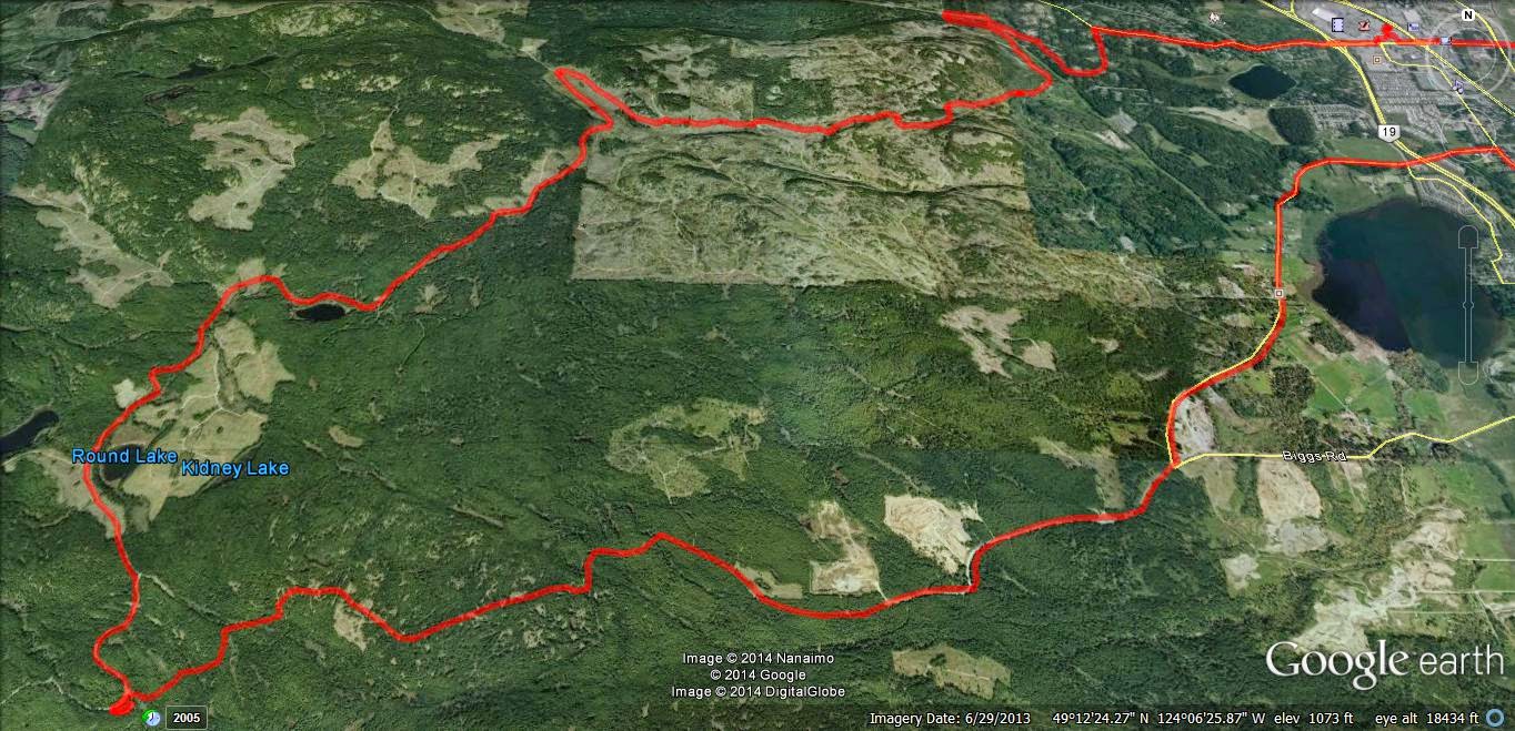
My track from Doumont to Moriarty Lake.
Made a quick visit to Rhododendron Lake and checked out the progress of the roads that appeared as if they're traveling towards Okay Mountain valley. They don't connect yet, although there's now a cool trail that climbs a dead-end spur with good views of Okay Mt. I took our usual route through the valley, back to the power lines, past Boomerang Lake and eventually Doumont using the original tank traps route.
 |
| Red shows track available from link directly above, (Doumont Rd to Moriarty Lake), and blue shows my return route. The elevation profile shows the red track only, with the red arrow locating the highest point at 1023m (3356ft). |
 |
| Doumont Rd to Moriarty Lake: Colour Coded Elevation Track |
Here's the whole ride from Doumont Rd to Moriarty lake in time-lapse at 4x speed:
And, the tank traps through the original route at 3x speed.

Saturday, September 06, 2014
Time Lapse Vid of Doumont to Bonnell Main New Route
Ok, it took me a nearly a week to produce this video as the much vaunted free software I raved about last week (GoPro Studio) has developed a bug. I lost the entire 3 hour production two days ago as it crashed. Since then, and while re doing the video, it crashed every ten minutes. I have re-installed, rebooted without success. Like me old step dad said, "you get what you pay for"...Don't forget to turn the settings up to HD. If you don't like the music, no complaints...just mute it :)
The video references points on the map below:

The video references points on the map below:
The ten minute epic...
Monday, September 01, 2014
Foothills to Bonnell Main - Alternative
 |
| (Click to Enlarge) GPX File HERE |
2 Steepish gulch, winds through trees. Could be muddy in wet weather. Surface is sandy duff. Ends in potentially boggy area. Little technical, but fun.
3 Right goes to Vipond, left to some interesting trails and new access to the Bonnell Main logging road.
4 Right goes to the more traveled Foothills trails and eventually to Phantom or, if you wish, to (6) the open red gate to the Sundew Main logging roads.
5 View point spur. Steep decline onto a vista where you can see the red gate across the valley. Scenic. Fun to ride.
6 The popular route into the Sundew Main Logging roads.
7 Steep incline on your right.
8 Overgown lake, now a reedy bog. Scenic, especially if you climb up the outcrop where you will see the NW Bay logging area on the other side of a small fringe of trees.
9 Descends into a single track alder trail, which may continue into the promised land...or not.
10 Access to Bonnell Main via an easy burm and small sandy single track trail through a small fringe of trees left by the logging company.
11 Bonnell Main (Goose Corner if you look at the associated photograph on GE). From here NW Bay is your oyster.
12 Viewpoint over Nanoose Bay, Maude Island etc. Nice small BBQ too!
13 Steep but fun ride up the "loop".
14 Red dirt descent. Again "fun".
15 Active quarry operation. Keep out. Let's not vandalize here and get our access blocked please...
16 Vipond Road Gate. Locked. No easy work around. A small ramp would work as the gate is low. But why? Head back past 15 and continue north to Phantom or Harwood Roads.
17 Rewarding connector back to gulch. Try this on your pegs, weight forward, clutching and at jogging speed in the dry. In the wet, make sure you have a trials tire on the back.
All in all this was a great ride! A few B level technical trails, but nothing to stop a dirt bike and average rider. Mostly, just great fun and as fast as you like. Watch for other riders, keep right and stop to look at the views.
Time Lapse Video is here...see more recent post...Explanation for late arrival in detail! (Couldn't get rid of the art below...too funny).
Paul.


Saturday, August 16, 2014
Go Pro Studio...Take One & Two
 |
| Usual loop, nothing new. Phantom Road to Doumont Road via Kidney Lake... |
Impressed as I am by Andy's time lapse video's via iPod App, I decided to produce a time-lapse video by stitching regular video (MP4) together and then speeding it up... I am using a Coleman Conquest helmet cam which has the option of shooting in MP4 in HD 1080P @ 30fps and shooting continuously while saving files in 1 minute segments which fit together seamlessly when played back (it's called car mode). The advantage of this is that the files can be uploaded or edited quickly if you wish to cherry pick segments from them rather than sorting through one huge file (which you can do if you are glutton for punishment).
So I downloaded Freemake Video and stitched 38 one minute MP4 files together, but stupidly checked the "transition" setting so they fade into each other. I then further complicated things by downloading Go Pro Studio (Free & no malware) to take that single file and speed it up to 6 times speed. So in all this file was converted from MP4, to as GSV file (a go pro tag), an AVI and then back to an MP4... This may have impacted quality, so, for my second attempt, I did the same project again in Go Pro Studio only, to see if the quality is improved with as few conversions as possible.
In Go Pro Studio you can select how many times you want to speed the video up from double speed to hundreds of times...I chose 6. So I'm not sure how a 38 minute video was shrunk to 5m30...that's more like 7 or more times... But it's free, and as me old (Step) dad used to say, "You get what you pay for..."
Attempt Two: Ok this was fun. Go Pro Studio allows you to incorporate slow motion into the vid, controlling it via percentage (100% being normal speed), so I have incorporated a couple of sections of 50% and one of 25%. Given this is a free program, I am very impressed with the flexibility and quality of the resulting product. The downside is that it does take a long time to process the video - my 38 minute video compressed to a 7 minute video in about half an hour...
To improve the quality, maximize the video, click settings and choose HD. Pretty darn good! Oh, and there's a secret message at the end, but don't tell Andy. Oh, and apologies for the music, but it is better than Andy's :)...Again - it was free...
The track for this ride can be found HERE.
[Edit, Aug 21st, Andy]
For a comparison, here's the same ride filmed in time lapse at 4x speed using an iPod and the app "TimeLapse." The last minute is unedited. Sorry--yes, too lazy to edit it properly.
Subscribe to:
Comments (Atom)