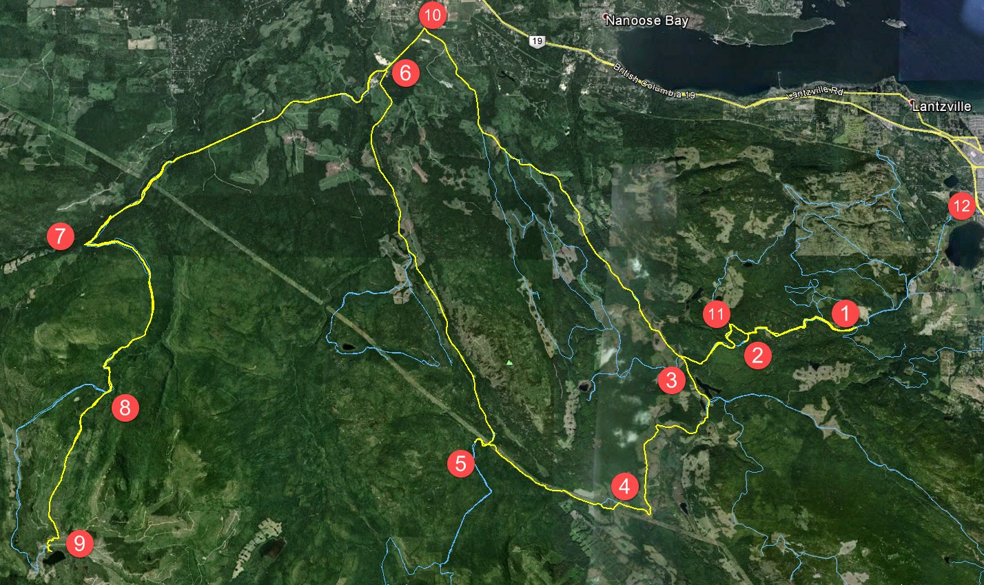
Here's the shape o' the day:
1. Entered the logging roads at Weigles Road/Doumont
2. Turned back at the "alternative tank traps" due to wind fall tree across the trail. We need a quader in here with a chainsaw!
3. Through the old tank traps, which is nicely cleared, and left turn on branch 142 towards Boomerang Lake.
4. Turned right and joined the power line trail.
5. Intended route towards the "hellevator" trail has turned into a pretty rapidly running river. We decided to head towards 155 main and blast up our recently more regular route.
6. Rode up Okay Mountain Valley, past the Rhododendron turning and turned left onto 155 main.
7. Uphill left turn onto signposted 155-160
8. Left onto connector trail to "Baker Street" (wikilocs track)
9. Through the connector and right down Baker Street to the logging roads surrounding Moriarty Lake. Took a quick visit to the Moriarty cabin where Paul was kind enough to share his British Rail type sandwich. Actually it was very good! (Yes it was - judging by the way you inhaled it! - P) Thanks mate.
10. Retraced route towards home. Dumped the bike up Baker Street. Darn you Moriarty! Followed 155 main up to a right turn onto branch 142
11. Back through the old tank traps.
12. Black Bear Pub for a pint o' IPA and ESB! Cheers!
 |
| Wind Fall timber across the trail through the alternative tank traps (2 on map above) |
 |
| Colour Coded Altitude Track |
 |
| New burned out (stolen?) truck appears on route to the Tank Traps on the Doumont side (shortly before 2 on map) |
 |
| Washed out! River running down the route towards the HeLLeVaToR (5 on map) |
 |
| Approaching Moriarty Lake Cabin on foot |
 |
| Moriarty Lake Cabin at 9 |
 |
| Moriarty Lake Cabin at 9 |
 |
| Moriarty Lake Cabin at 9 |
 |
| Moriarty Lake Cabin at 9 Pack your garbage out...please |
Above: Real Time Vid of the "Highlights" of the route to Moriarty Lake.
Time Lapse: Turning off 155-160 onto connector leading to Moriarty Lake ("Baker Street")
Time Lapse: Back up Baker Street connector trail towards 155-160
Time Lapse: Return trip from 155
Track Flyover on Google Earth
GPS Track Playback at 100x Speed


No comments:
Post a Comment
Please Leave a Comment: