Showing posts with label 155n. Show all posts

Tuesday, April 18, 2017

Revisiting the "Marianas Mars" CF-LYJ Crashsite


Some time ago we visited the crash site of the "Marianas Mars" CF-LYJ water bomber near Moriarty Mountain on Vancouver Island.  The "Marianas Mars" was one of four water bombers in service in the Vancouver Island region, each charged with putting out forest fires for Macmillan Bloedel.  We had looked briefly at the site during a ride to Youbou in 2015, but time was short on this earlier ride and we left the site quickly without really giving it the time it deserved.  Click here for details of that ride.

More recently, Dan F., one of our readers, fellow rider and associate of the local Nanaimo Historical Society, contacted us and invited us to a presentation by a past Mac Blo Administrator who has first hand knowledge of the crash and who was present during the extraction of wreckage during the aftermath of this tragedy.

His presentation was excellent.  He included historical details of the four Mars bombers, and covered details of two major fires in our local area, one being the large fire on Mt. Moriarty where the Marianas came down.  The plane had been in military service until 1956 and was eventually sold in 1959 and converted into a forest fire fighting aircraft (CF-LYJ) by Macmillan Bloedel.  The plane crashed on June 23rd, 1961.  It's believed that the water drop mechanism failed and the aircraft was unable to achieve the altitude necessary to clear the mountain.  All four crew members on board perished.  (Wikipedia reference).

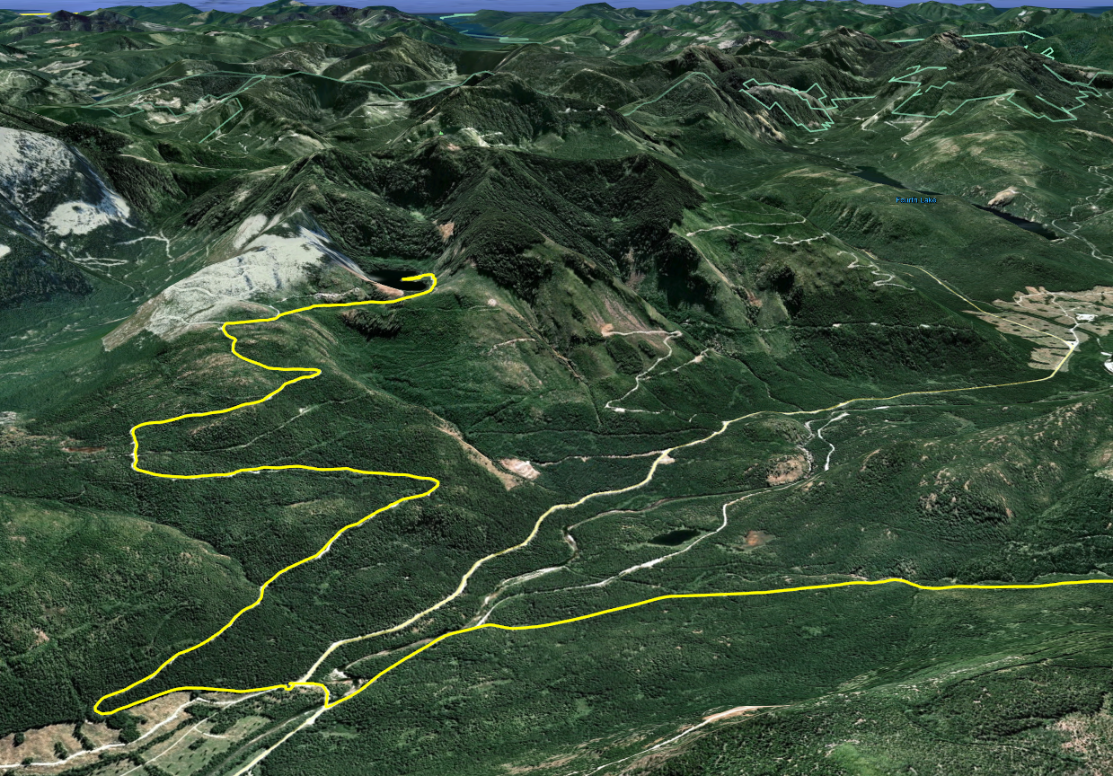
This was a perfect ride to open the season and a great reason to begin posting blog entries once again. Paul and I decided to revisit the site and spend a little more time looking around.  Let's get a look at the track for this ride.  Here's an overview using Google Earth to fly over the route: (After you hit play, you'll see this better at full screen settings.  Takes a few seconds for the view to settle down).


Here's the track viewed with Garmin Navigator (at 1000x speed):


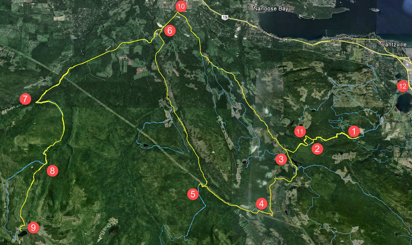
1.  We entered the logging roads from our usual Doumont/Biggs Rd. side.  Neither of us have been through here for a while since Timberlands began their most recent war against riders entering the region.  We were pretty interested in seeing how impregnable the "tank traps" area is to date.   

2.  Whaddaya know, you can get through!  That's right, it needs patching up again guys!  Get your finger out!  ;)  Quadders and bikers have bridged the newly dug traps and a route goes through to a location very close to the old "tank traps" exit.  (I've been asked in the past not to reveal news of entrances into the area, but quite honestly there's no secret here.  We're all using these common routes and the logging company is well aware when these major routes become compromised again.  In fact, they must expect it to happen pretty much on schedule.  It's nothing new:  They patch it...  We get through... They patch it...  etc).

3.  Turned N.W. onto Branch 142

4.  Turned left traveling  S.W. on 155 Main

5.  Turned left onto 155N.  This logging road entrance was recently gated.  Access is possible by bike and likely by quad, although it's tight.  You won't get a truck in there.


There are some pretty good views of the Strait of Georgia looking N.E. from high points of the road on 155N as it curves its way up towards the crash site.

 
 We hit snow as we got a little higher towards the crash site.  We were able to ride through it and managed to get right up next to the coordinates.


6.  The crash site at  N49° 10.996' W124° 22.996'.  It's pretty easy to find.  Park your bike on the logging road near the coords, and walk into the bush on the right side (A).

 
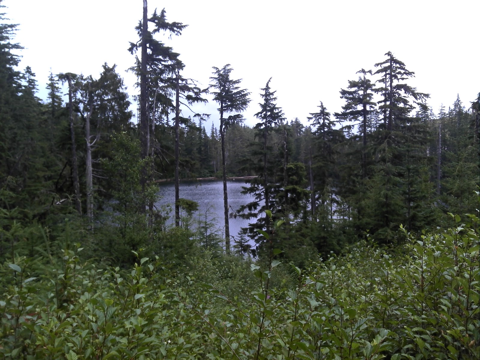
You can make out a clearing from the road where trees are thinned over an old logging road that runs at 90° to the road where you park.


You continue along this old remnant of a road for a couple of hundred yards and then enter the trees on the right side (B).  Look for trees marked in blue paint.

 
 Most are numbered and some appear to have the word  "OUT" painted above a number.  We were speculating on whether this number referred to a piece of wreckage or perhaps even human remains.  Numbers appear to reach into the twenties.  There are quite a few blue markers sprayed near the coords given above, although they continue as you proceed towards the N.W.


We stumbled upon an empty bear den half way along our short hike.  Not the sort of thing you want to get too close to during the spring, but it appeared to be safely abandoned some time ago.


(Er.... no, didn't happen).

Eventually you reach a steep downward slope where there is old fire damage visible in the remaining stumps and roots.  Pretty clear evidence of a fiery crash site is visible here (C).  We both looked carefully for any sign of wreckage all through the track shown above, but found no metal at all.  We looked in a few areas which appeared to be compressed from impact using a metal detecting probe, but found nothing metallic at all.

 
 At location C we separated and Paul traveled down the slope in the hope of finding fragments that might have made it to the bottom, (at the fire site).  Great idea, but unfortunately he didn't find anything there either.  Kudos to the MacBlo cleanup crew!  You guys removed every trace!  It's a heavily treed area and it very likely gets deep annual coverage of needles, covering any small traces they might have been left.  It's an interesting site to investigate nontheless; if you look carefully, the direction of travel can be seen by following broken stumps and old fractured and fallen trees from the fire location towards the blue marked trees at the coordinates.


 7.  We retraced our route and continued on towards Cottle Lake to see if the route was still blocked by gate.  The gate was locked.


8.  We looked at alternative ways of getting back through the tank traps, but had no luck.  The route we followed, which we have referred to earlier as the "tank traps alternative route," ended at a dead end with no clearly visible path through.  We then returned the same way we had entered the area.


9.  ESB poured like rain at the Black Bear Pub!

Here's a quick look at the elevations on this route:


You can get a better look if you click on these pics.


The movie feature.  Go get some popcorn:


Excellent ride!  Big thanks to Dan for inviting us out to hear that presentation.


Track for this ride is available here, at wikiloc.com


*UPDATE: May 22nd, 2017*

YouTuber "Cars show Island" send us a link to the YouTube video "Marianas Mars The Dean Fire 1960 British Columbia" which shows excellent footage of the Marianas Mars in action over the Nicola Valley.  He tells me it's the only known footage of this Mars water bomber.

Go give him a "like" if you get a minute:


********************************************************************************


As a side note, the Aviation Safety Network website list this crash location with a lower level of accuracy.  (Possibly they desired it to be this way, but more likely they just found Moriarty Mountain on a map and pinned it).  Their listed location is 7km out, so don't go there!  ;) 


Sunday, October 26, 2014

Down Baker Street to Moriarty's Lair

Our recent rides have been centered around using the excellent new roads created off 155 main by our friendly outdoors-sharing logging company.  Paul and I took a round-about trip out that way today to see if we could navigate our newly-discovered trail that leads to Moriarty Lake, aptly named Baker Street, without running into TimberPest's gargantuan road blockage.  We walked it during our previous ride in that area and decided that it was quite do-able if the weather remained dry.  So we picked a nice soggy Sunday with lots of running water to attempt riding it.  :)  It was a terrific ride and a great success!

Here's the shape o' the day:


1.  Entered the logging roads at Weigles Road/Doumont
2.  Turned back at the "alternative tank traps" due to wind fall tree across the trail.  We need a quader in here with a chainsaw!
3.  Through the old tank traps, which is nicely cleared, and left turn on branch 142 towards Boomerang Lake.
4.  Turned right and joined the power line trail.
5.  Intended route towards the "hellevator" trail has turned into a pretty rapidly running river.  We decided to head towards 155 main and blast up our recently more regular route.
6.  Rode up Okay Mountain Valley, past the Rhododendron turning and turned left onto 155 main.
7.  Uphill left turn onto signposted 155-160
8.  Left onto connector trail to "Baker Street" (wikilocs track)
9.  Through the connector and right down Baker Street to the logging roads surrounding Moriarty Lake.  Took a quick visit to the Moriarty cabin where Paul was kind enough to share his British Rail type sandwich.  Actually it was very good! (Yes it was - judging by the way you inhaled it! - P)  Thanks mate.
10. Retraced route towards home.  Dumped the bike up Baker Street.  Darn you Moriarty!  Followed 155 main up to a right turn onto branch 142
11.  Back through the old tank traps.
12.  Black Bear Pub for a pint o' IPA and ESB!  Cheers!

Wind Fall timber across the trail through the alternative tank traps (2 on map above)


Colour Coded Altitude Track

New burned out (stolen?) truck appears on route to the Tank Traps on the Doumont side (shortly before 2 on map)

Washed out!  River running down the route towards the HeLLeVaToR (5 on map)

Approaching Moriarty Lake Cabin on foot

Moriarty Lake Cabin at 9

Moriarty Lake Cabin at 9

Moriarty Lake Cabin at 9

Moriarty Lake Cabin at 9 Pack your garbage out...please


Above: Real Time Vid of the "Highlights" of the route to Moriarty Lake.


Time Lapse: Turning off 155-160 onto connector leading to Moriarty Lake ("Baker Street")

 Time Lapse: Back up Baker Street connector trail towards 155-160

Time Lapse: Return trip from 155

 
Track Flyover on Google Earth

GPS Track Playback at 100x Speed


Here's a direct track from doumont to Lake Moriarty.  Use it in conjunction with this track of the connector (Baker St) to get right down to the lake.  The track for the entire route, exactly as it appears on this blog page, can be found here.


Monday, October 06, 2014

155 Through to Moriarty: Baker Street

"Baker Street" is a way into Moriarty Lake from 155
Andy and I found a trail into Moriarty Lake from 155.  "Baker Street"  is perfectly doable for a bike in drier weather, and much more palatable, IMHO, than the old key trail.  The blocked access to 155-160 is for reference.  To get to Nanaimo Lakes Main, turn left (east) at "Moriarty's Key". ATVers that we met later told us the access route to it (green trail below) is easy.  More maps and a video below.

While it looks overgrown on GE, it is not.  The single track quad trail is clearly defined and obviously well used.
The unexplored green trail is accessed easily from 155-160.  
The video is not very exciting, but does let you take a gander at the trail surface and terrain.  It goes from "Sherlock's Trick" to "Moriarty's Key" From there, 4th Lake, "The Great Divide", Nitinat Main etc. are all accessible.  Vancouver Island's backroads are your oyster...Again, apologies for the music...but it fits...;)   [Apology NOT accepted ~Andy]


Google Earth flyover from 155 to the lake shore.   (This is the track of the connector trail that can be downloaded right below this movie.  Use it with the track "Doumont to Moriarty Lake" to find 155).

Here's a track of the connector trail which is a left turn off of 155N when heading SW, (the "unexplored green trail" shown in the photo above).  The track shows the route to the lake shore, bypassing the nasty road block encountered when approaching the lake using just the major logging route.

Couldn't resist a shot of the beast.  Handsome Devil, aint she!


Monday, October 08, 2012

Deadhorse Creek Gold Mine

Holy cow... No blog updates for a while now!  This one was such a great ride it must be recorded.  Paul and I have been waiting to do this ride for quite some time.  I found reference to a gold mine for sale in the Mt. DeCosmos area towards the end of the riding season last year.  Now that we have found a tried and true route into the Nanaimo Lakes region without having to use a gate, we decided the time was finally right to go and find this mine.  Actually we attempted to get there a week earlier following trails along the north side of Decosmos from the power lines, but the trail didn't look too friendly.  We walked it and managed to reach the DeCosmos road and we quite likely could have got the bikes through the rocky trail, but we just didn't welcome the struggle.  So, on Sept 29th we made our way through the standard Moriarty Lake route using what we have come to call "the key trail."

Here's our route to #19 (the mine) and back to the starting point at Doumont Rd:


 1.  Stopped and watched some amazing young riders flying over the track at the Nanaimo Motocross Assoc. (Wastelands).  Very skillful riders on that track.  We met up with Ryan there, who was able to join us on his 450 KTM.  VERY nice bike!
2.  Through the tank traps.
3.  Left turn on Branch 142 towards Boomerang Lake.
4.  Past Boomerang Lake, turned right and then right again towards the power lines route.
5.  Headed NW along the power lines.
6.  Right turn to follow Okay Mountain Valley, (on west side of mountain).
7.  Left onto 155 main.  Got to try Ryan's KTM here... WOW!
8.  Turned left off of 155 towards mountain ridge NE of Moriarty Mountain onto 155N.
9.  Left turn towards mountain ridge.
10.  Ridge Trail NE of Mt. Moriarty
11.  Turned right onto "key trail" linking the northern logging roads to the southern roads (thanks Google E).  There's a nasty downhill section full of young alders shortly after this location.  (Might not be easily accessible if quaders don't hurry up and help us in keeping the trail usable).
12.  Down through alders.
13.  Left turn towards Healy Lake.  This was a failed attempt to get through to the DeCosmos roads by cutting past Healy Lk. 
14.  We stopped briefly at the lake to take a look:  Catch and release with non-barbed hooks here.  Daily limit=0. 
15.  Past the lake it began to get pretty steep and rocky.  Too rich for my blood!  Ryan had little trouble blasting through this section on his KTM, but Paul and I would have had much greater difficulty.  Do-able I think, but not without pushing and pulling each other.  :(  Much easier to continue through Nanaimo River Road.
16.  Back onto the main trail and downhill to Nanaimo River Road.
17.  Left turn at the beginning of Second Lake to follow the road leading up Mt. DeCosmos.
18.  Right turn onto mine trail and a sharp left again up a well grown in trail that begins to climb a bit steeper.

19.  We reached the Deadhorse Creek Gold Mine.  The narrow trail comes to an abrupt end where it meets the creek.  You can see the mine opening from here if you look slightly upwards at about 2 o'clock.  You need to climb down into the creek bed, which is about 15ft below you.  Someone has very kindly attached a couple of ropes to a tree to help you climb down about ten feet.  Once down, the entrance is clearly visible to your right and easy to reach.  (It has a flat roof, which I found a bit surprising).  We entered the mine for about 50m and encountered a vertical ventilation shaft that lets a good deal of light in.  From here there are a couple of spurs leading off in different directions.

We discovered that Paul had acquired a large metal staple in his rear tire.  It was pretty clear that a gentle ride out would be the best fix.  Excellent bit of riding on his part, not only in protecting the rim from damage, but staying upright on a tire with broken beads down a pretty bumpy trail.

20.  Luckily, the yellow gate was opened by a truck ahead of us and we escaped through without needing to retrace our route heading north.  We turned left shortly after the main gate and continued towards Doumont on logging roads once more.
21.  Continued along the SW side of Blackjack Ridge.
22.  Right towards Boomerang Lake.
23.  Thru the Tank Traps and out to Doumont to put Paul's sick bike onto Ryan's truck.  ;)

Here's some photos:

Healy Lake

Parked at Healy Lake
 
The end of the trail leading up to Deadhorse Creek.  You gotta wonder how that staple managed to get up there.  Surely nobody would be stupid enough to keep riders away from looking at a mine by puncturing their tires? 
 
Climbing down into the creek bed

Climbing down using the ropes.  You can see the entrance to the mine in this shot:  Look at the tree on the right.  Now look between the two sets of main branches on the left side of this tree.  The darker spot in the gap between is the mine opening.

You can see the mine entrance a little clearer here.  Ryan is pointing his camera directly at it.  I'm standing at the bottom of the ropes where we climbed down.


The mine entrance, (lit by daylight).  Square!?  I thought rounded would have been stronger/safer.  What do I know?
    
In the mine.  Looking back towards the entrance.

Looking up.  This is a vertical shaft about 50m into the mine.  Pretty wet here...  Lots of water dripping into the mine from this spot.  There were a couple of rotting timbers that appeared to be carrying some load at this location.  Good time to watch your step a bit more carefully.  Tons of ventilation happening... No worries about gasses, although I guess that's more of a coal mine problem.

Oh, another shot of the entrance, like it's any different when you're on the way out.

Ryan at the entrance and Paul further back making ridiculous "scary faces" with his little Walmart flashlight.

Detail view of the road past Healy Lk. where we turned back.

Detail view of the DeCosmos road that begins left, right before Second Lake.  The top shows the right turn onto the mine road and the following left turn up towards the mine.
Outstanding ride!  Highly recommended!

(Updated route to this mine with a downloadable track can be found here).

Thursday, August 30, 2012

Off to Heart Lake ❤

Last winter Paul blogged about a route to Heart Lake that he was keen on trying.  Heart Lake is situated at an approx altitude of 860m on the eastern side of Green Mountain, about 30km SW of downtown Nanaimo.  Yesterday Paul, Sebastian and I headed out to find Heart Lake on what is becoming a standard route for us:


1.  Began at Doumont Road and went through the tank traps before turning left.
2.  Travelled over the new bridge...  No new yellow gate :)
3.  Turned right at Boomerang Lake's southern intersection.
4.  Followed power lines trail. (Many improvements have been made to the roads here... The loggers may be busy soon).
5.  Turned right off of power lines route onto Okay Mt. valley road.
6.  Turned left onto 155 Main.
7.  Turned left onto 155N.
8.  Travelled up the ridge road. (It was cloudy and rainy today... No views of Mt. Moriarty).

Blueberries on the ridge road

9.  Went through the "key trail" and turned left onto a possible alternative to having to descend through the alders as we usually do on this road.
10.  Fought our way through heavy young alder growth. (It was heavier than the standard route).

mossy road surface on the "alders alternative" road before we encountered heavier alders

Paul reaches a clearing along the "alders alternative"
Sebastian emerges through the alders
11.  We stopped the bikes and walked to check the route.  We didn't walk all the way, although we went far into the overgrown road.  Not a good route without a chainsaw.  If you're a quad rider, please head up here with all your quader friends and stomp all over the alders.
12.  After deciding that the trees were too thick we retraced our steps and followed the usual road through the alders towards Nanaimo River Road.

those alders will grab onto anything from front brake levers to cameras
13.  Over the bridge and left towards Heart Lake.  (A small trail to the left of the gate appears to have been provided by the logging company for small vehicles to pass through).

(top left to bottom right)  A small trail left of gate provides access.   It's difficult to see the road you need to follow when looking on Google Earth.  Follow an immediate fork to the right after the gate.  Both forks head to the lake although the right fork is more direct.
 
14.  Uphill road to Heart Lake.  It's a steep but fairly easy ride.  There are many drainage ditches on this road that keep your speed in check.

climbing up towards the lake


15.  Heart Lake at near 900m.  Beautiful lake with a depressing "grapple-yarded" mess of logs and stumps on the far shore.  What a terrible mess these people have made of one of our beautiful lake areas!  :(  Surely there are other spots you could have logged.

approaching the lake

290° stitched panoramic from the western shore of Heart Lake
good fishing cliffs on western shore

There are a number of good fishing spots on the road side of the lake.  Some spots are off of low cliffs while others can be found nearer to the water level.  We fished for a little over an hour today, (I think), and we saw very little action.  Eventually we walked out with three fish between us.  We saw a bear on the far side, which helped to make things more interesting.  (Unfortunately, the bear was looking for trees and had less luck than us).

One of us took a spill on the way out.  No large injuries luckily...  Just an improved healthy respect for downhill logging roads with ditches.  ;)  Lesson learned!

It was a terrific ride and it appears that we all really enjoyed it except for the spill. 

Here's our route spelled out on my GPS map at 100x real time.  (If you increase the resolution at the bottom right of the window, you can read the writing without squinting). :)