Showing posts with label okay valley. Show all posts

Sunday, October 26, 2014

Down Baker Street to Moriarty's Lair

Our recent rides have been centered around using the excellent new roads created off 155 main by our friendly outdoors-sharing logging company.  Paul and I took a round-about trip out that way today to see if we could navigate our newly-discovered trail that leads to Moriarty Lake, aptly named Baker Street, without running into TimberPest's gargantuan road blockage.  We walked it during our previous ride in that area and decided that it was quite do-able if the weather remained dry.  So we picked a nice soggy Sunday with lots of running water to attempt riding it.  :)  It was a terrific ride and a great success!

Here's the shape o' the day:


1.  Entered the logging roads at Weigles Road/Doumont
2.  Turned back at the "alternative tank traps" due to wind fall tree across the trail.  We need a quader in here with a chainsaw!
3.  Through the old tank traps, which is nicely cleared, and left turn on branch 142 towards Boomerang Lake.
4.  Turned right and joined the power line trail.
5.  Intended route towards the "hellevator" trail has turned into a pretty rapidly running river.  We decided to head towards 155 main and blast up our recently more regular route.
6.  Rode up Okay Mountain Valley, past the Rhododendron turning and turned left onto 155 main.
7.  Uphill left turn onto signposted 155-160
8.  Left onto connector trail to "Baker Street" (wikilocs track)
9.  Through the connector and right down Baker Street to the logging roads surrounding Moriarty Lake.  Took a quick visit to the Moriarty cabin where Paul was kind enough to share his British Rail type sandwich.  Actually it was very good! (Yes it was - judging by the way you inhaled it! - P)  Thanks mate.
10. Retraced route towards home.  Dumped the bike up Baker Street.  Darn you Moriarty!  Followed 155 main up to a right turn onto branch 142
11.  Back through the old tank traps.
12.  Black Bear Pub for a pint o' IPA and ESB!  Cheers!

Wind Fall timber across the trail through the alternative tank traps (2 on map above)


Colour Coded Altitude Track

New burned out (stolen?) truck appears on route to the Tank Traps on the Doumont side (shortly before 2 on map)

Washed out!  River running down the route towards the HeLLeVaToR (5 on map)

Approaching Moriarty Lake Cabin on foot

Moriarty Lake Cabin at 9

Moriarty Lake Cabin at 9

Moriarty Lake Cabin at 9

Moriarty Lake Cabin at 9 Pack your garbage out...please


Above: Real Time Vid of the "Highlights" of the route to Moriarty Lake.


Time Lapse: Turning off 155-160 onto connector leading to Moriarty Lake ("Baker Street")

 Time Lapse: Back up Baker Street connector trail towards 155-160

Time Lapse: Return trip from 155

 
Track Flyover on Google Earth

GPS Track Playback at 100x Speed


Here's a direct track from doumont to Lake Moriarty.  Use it in conjunction with this track of the connector (Baker St) to get right down to the lake.  The track for the entire route, exactly as it appears on this blog page, can be found here.


Monday, October 08, 2012

Deadhorse Creek Gold Mine

Holy cow... No blog updates for a while now!  This one was such a great ride it must be recorded.  Paul and I have been waiting to do this ride for quite some time.  I found reference to a gold mine for sale in the Mt. DeCosmos area towards the end of the riding season last year.  Now that we have found a tried and true route into the Nanaimo Lakes region without having to use a gate, we decided the time was finally right to go and find this mine.  Actually we attempted to get there a week earlier following trails along the north side of Decosmos from the power lines, but the trail didn't look too friendly.  We walked it and managed to reach the DeCosmos road and we quite likely could have got the bikes through the rocky trail, but we just didn't welcome the struggle.  So, on Sept 29th we made our way through the standard Moriarty Lake route using what we have come to call "the key trail."

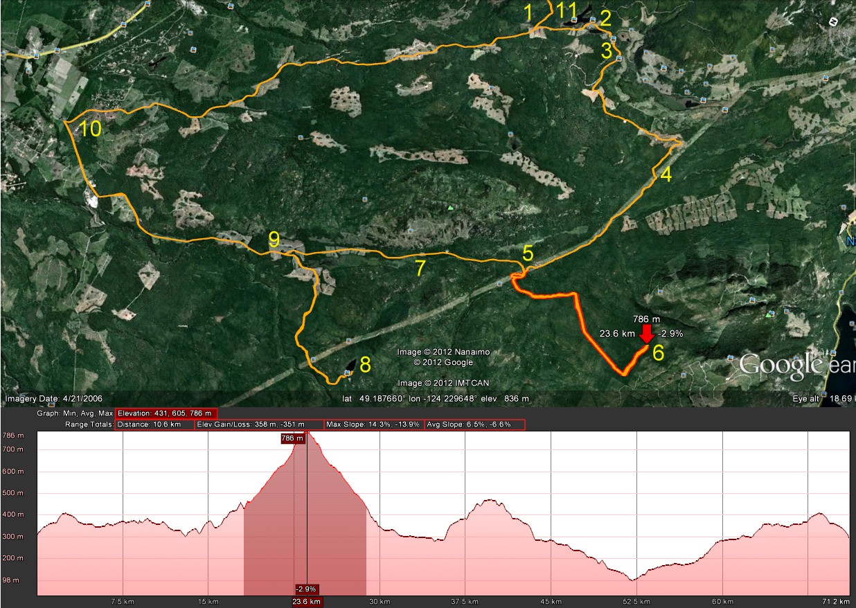
Here's our route to #19 (the mine) and back to the starting point at Doumont Rd:


 1.  Stopped and watched some amazing young riders flying over the track at the Nanaimo Motocross Assoc. (Wastelands).  Very skillful riders on that track.  We met up with Ryan there, who was able to join us on his 450 KTM.  VERY nice bike!
2.  Through the tank traps.
3.  Left turn on Branch 142 towards Boomerang Lake.
4.  Past Boomerang Lake, turned right and then right again towards the power lines route.
5.  Headed NW along the power lines.
6.  Right turn to follow Okay Mountain Valley, (on west side of mountain).
7.  Left onto 155 main.  Got to try Ryan's KTM here... WOW!
8.  Turned left off of 155 towards mountain ridge NE of Moriarty Mountain onto 155N.
9.  Left turn towards mountain ridge.
10.  Ridge Trail NE of Mt. Moriarty
11.  Turned right onto "key trail" linking the northern logging roads to the southern roads (thanks Google E).  There's a nasty downhill section full of young alders shortly after this location.  (Might not be easily accessible if quaders don't hurry up and help us in keeping the trail usable).
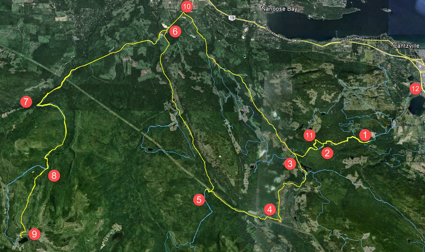
12.  Down through alders.
13.  Left turn towards Healy Lake.  This was a failed attempt to get through to the DeCosmos roads by cutting past Healy Lk. 
14.  We stopped briefly at the lake to take a look:  Catch and release with non-barbed hooks here.  Daily limit=0. 
15.  Past the lake it began to get pretty steep and rocky.  Too rich for my blood!  Ryan had little trouble blasting through this section on his KTM, but Paul and I would have had much greater difficulty.  Do-able I think, but not without pushing and pulling each other.  :(  Much easier to continue through Nanaimo River Road.
16.  Back onto the main trail and downhill to Nanaimo River Road.
17.  Left turn at the beginning of Second Lake to follow the road leading up Mt. DeCosmos.
18.  Right turn onto mine trail and a sharp left again up a well grown in trail that begins to climb a bit steeper.

19.  We reached the Deadhorse Creek Gold Mine.  The narrow trail comes to an abrupt end where it meets the creek.  You can see the mine opening from here if you look slightly upwards at about 2 o'clock.  You need to climb down into the creek bed, which is about 15ft below you.  Someone has very kindly attached a couple of ropes to a tree to help you climb down about ten feet.  Once down, the entrance is clearly visible to your right and easy to reach.  (It has a flat roof, which I found a bit surprising).  We entered the mine for about 50m and encountered a vertical ventilation shaft that lets a good deal of light in.  From here there are a couple of spurs leading off in different directions.

We discovered that Paul had acquired a large metal staple in his rear tire.  It was pretty clear that a gentle ride out would be the best fix.  Excellent bit of riding on his part, not only in protecting the rim from damage, but staying upright on a tire with broken beads down a pretty bumpy trail.

20.  Luckily, the yellow gate was opened by a truck ahead of us and we escaped through without needing to retrace our route heading north.  We turned left shortly after the main gate and continued towards Doumont on logging roads once more.
21.  Continued along the SW side of Blackjack Ridge.
22.  Right towards Boomerang Lake.
23.  Thru the Tank Traps and out to Doumont to put Paul's sick bike onto Ryan's truck.  ;)

Here's some photos:

Healy Lake

Parked at Healy Lake
 
The end of the trail leading up to Deadhorse Creek.  You gotta wonder how that staple managed to get up there.  Surely nobody would be stupid enough to keep riders away from looking at a mine by puncturing their tires? 
 
Climbing down into the creek bed

Climbing down using the ropes.  You can see the entrance to the mine in this shot:  Look at the tree on the right.  Now look between the two sets of main branches on the left side of this tree.  The darker spot in the gap between is the mine opening.

You can see the mine entrance a little clearer here.  Ryan is pointing his camera directly at it.  I'm standing at the bottom of the ropes where we climbed down.


The mine entrance, (lit by daylight).  Square!?  I thought rounded would have been stronger/safer.  What do I know?
    
In the mine.  Looking back towards the entrance.

Looking up.  This is a vertical shaft about 50m into the mine.  Pretty wet here...  Lots of water dripping into the mine from this spot.  There were a couple of rotting timbers that appeared to be carrying some load at this location.  Good time to watch your step a bit more carefully.  Tons of ventilation happening... No worries about gasses, although I guess that's more of a coal mine problem.

Oh, another shot of the entrance, like it's any different when you're on the way out.

Ryan at the entrance and Paul further back making ridiculous "scary faces" with his little Walmart flashlight.

Detail view of the road past Healy Lk. where we turned back.

Detail view of the DeCosmos road that begins left, right before Second Lake.  The top shows the right turn onto the mine road and the following left turn up towards the mine.
Outstanding ride!  Highly recommended!

(Updated route to this mine with a downloadable track can be found here).

Thursday, June 28, 2012

Finding the Far Shore of Rhododendron Lake

Sebastian and I took a ride out to Rhododendron Lake yesterday to see if we could find the far shore.  Every time we get out to Rhodo Lake, we look across to the other side which appears to offer much better fishing sites since the shoreline looks much wider.  Sebastian had never ridden out that way, so it served a second purpose of familiarizing him with some of the excellent riding trails that we've discovered while exploring the area.

Here's the route:


(Blue Numbers)
1.  Entered on the Doumont Trail
2.  Left towards Boomerang Lake
3.  Right on Boomerang's southern intersection, and right at the next one too
4.  Right... joined the power lines trail
5.  Right onto Okay Mountain valley road
6.  Left towards Rhododendron Lake
7.  Usual Rhodo location.  Short hike to lake
8.  Far side of the lake (See detail above and descriptions below)
9.  Turn right off Englishman River Main onto Branch 142
10.  Doubled back... New plan!  Left Br. 142 and took Okay Lake Trail
11.  The excellent descent towards Boomerang on one of my favourite local trails
12.  A quick visit to the Boomerang fishing site
13.  Back at the Doumont entrance.

(Detail: Green Numbers)
1.  Searching for road into Rhodo Lake
2.  Right turn...  Very clear and obvious trail
3.  Rocky trail with some mud pools at this time of year.  The very final section was a bit more difficult to get up.  We both spun out on a large boulder and both of us needed a push from behind to get out.  Nothing too bad; we were out fairly quickly, but I might park the bike on the upper side of this rock next time.  It's almost right at the fishing site.

Some perspective


There are more fishing spots on this side of the lake, although it's quite shallow off the shore in many of the fishing locations.  There's one good casting spot that is visibly deeper than the others.  I caught two small trout in this location.  Sebastian was fishing off to the right where a long cast is needed to get out to a decent depth.  There were many fish jumping directly ahead of him, so I'm thinking that would be a good bait fishing spot if you used a heavy enough weight to get far enough out.  Definitely a good spot to try again, but a pretty useless spot if anyone beats you out there, (just like the other side).


A not-so-good stitched image made from my GPS photos.  Gives a rough idea of how the lake looks on that side.

Looking left (SE)
Parked near the lake shore
    
Our Route:


Terrific ride...  71km altogether.  Thanks Sebastian!

Thursday, June 21, 2012

Another Try Towards Mt. DeCosmos

I decided to have another try at getting to Nanaimo Lakes Road using the "roads" (pfffhgh) leading towards Mt. Decosmos, (from the north).  I tried attacking Nanaimo Lakes Road from trails to the east of today's route a few weeks ago, and I noticed there was another possible way in just up the power lines route that needed to be tried.  Here's the route:


1.  Entered via Doumont Trail
2.  Turned right south of Boomerang Lake
3.  Right at next intersection towards the power lines route
4.  Onto the power lines route heading west
5.  Trail leading towards Decosmos Mountain
6.  The climb...  Very old and overgrown trail...  Turned back at ~790m
7.  Okay Mt Valley towards Rhododendron Lake
8.  Rhododendron Lake to take pics of rhodos!
9.  Rain!  alt route back towards 142 main
10.  142 main back to Doumont and civilization

The plan was to follow this pink route:


Left...  Beginning the "Decosmos" trail.
 
It was a tall order and I really didn't expect to make it all the way, but I wanted to see what it looked like out there.  The trail wasn't that bad for the most part: There was the odd rocky patch, but it was generally pretty easy to pick through it.  It became difficult towards the end, not because of the climb, but the incredible overgrowth of alders on this pretty old disused logging road.  I got pretty fed up of stopping to pull branches out of my way and as it began to thicken with small trees I eventually gave up the ghost.  I'm still wondering how far you can get on this road though; there were occasional quad tracks leading through all that mess.  I'll head back this summer and give it another go.

Mirkwood!
 So, what now?  I promised my mother-in-law that I would take some photos of the blooms on Rhodo Lake.  Off I went!  I came back down the hill and headed up the Okay Mountain valley towards Rhodo Lake.

It was beautiful at the lake today.  Not a soul around for miles.  I reached the lake, hiked in and took my photos:

180 degree panoramic of the lake
 
Some blooms are done already, but there are plenty about still


That was it...  I took the alternate route back to Doumont along Englishman River Main to Branch 142.  72Km of logging roads altogether.


Thursday, May 17, 2012

Riding the West Side of Okay Mountain

Beautiful day today, and since I got out of the dentist at a decent time, I decided to blast up Okay Mountain to check out the trail visible when passing through the valley on the way to Rhododendron Lake.

Here's today's route:

1. begin Doumont Trail  2.straight at Boomerang intersection (int B)  3. sharp right towards Okay Lk.  4. left up Okay Mt.  5. About face at 725m to retrace route, turning left to Branch 142.  6. Back to "int B"  7. left to the tank traps and Doumont Tr. 


Some perspective.
Nerdy 3D view (Needs red/cyan glasses)
Elevation profile (entire ride, Doumont and back)
 
There was nobody out there today during the entire ride.  I loved it!  Silent everywhere.  Okay Mountain's west trail is fantastic.  A little overgrown here and there, but the views of Decosmos and the valley make it really worth picking through the odd fir tree and chunk of broom.

Broom covered trails
Looking NW towards Rhododendron Lake
A nicer grassy section of the trail (Facing NW)

Okay Valley facing almost due south.  Mt. Decosmos far left
Looking down on the valley road to Rhodo Lake

Further along the trail.  A clearer view of Decosmos is emerging.

Zoomed in
Really great ride! 

-----------------------------------

June 03/2012 - A couple of added 3D anaglyph pics below. (You'll need red/cyan glasses):