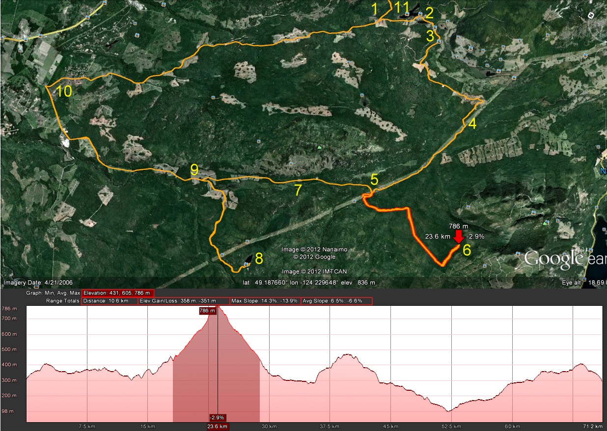
Sebastian and I took a ride out to Rhododendron Lake yesterday to see if we could find the far shore. Every time we get out to Rhodo Lake, we look across to the other side which appears to offer much better fishing sites since the shoreline looks much wider. Sebastian had never ridden out that way, so it served a second purpose of familiarizing him with some of the excellent riding trails that we've discovered while exploring the area.
Here's the route:
(Blue Numbers)
1. Entered on the Doumont Trail
2. Left towards Boomerang Lake
3. Right on Boomerang's southern intersection, and right at the next one too
4. Right... joined the power lines trail
5. Right onto Okay Mountain valley road
6. Left towards Rhododendron Lake
7. Usual Rhodo location. Short hike to lake
8. Far side of the lake (See detail above and descriptions below)
9. Turn right off Englishman River Main onto Branch 142
10. Doubled back... New plan! Left Br. 142 and took Okay Lake Trail
11. The excellent descent towards Boomerang on one of my favourite local trails
12. A quick visit to the Boomerang fishing site
13. Back at the Doumont entrance.
(Detail: Green Numbers)
1. Searching for road into Rhodo Lake
2. Right turn... Very clear and obvious trail
3. Rocky trail with some mud pools at this time of year. The very final section was a bit more difficult to get up. We both spun out on a large boulder and both of us needed a push from behind to get out. Nothing too bad; we were out fairly quickly, but I might park the bike on the upper side of this rock next time. It's almost right at the fishing site.
Some perspective
There are more fishing spots on this side of the lake, although it's quite shallow off the shore in many of the fishing locations. There's one good casting spot that is visibly deeper than the others. I caught two small trout in this location. Sebastian was fishing off to the right where a long cast is needed to get out to a decent depth. There were many fish jumping directly ahead of him, so I'm thinking that would be a good bait fishing spot if you used a heavy enough weight to get far enough out. Definitely a good spot to try again, but a pretty useless spot if anyone beats you out there, (just like the other side).
A not-so-good stitched image made from my GPS photos. Gives a rough idea of how the lake looks on that side.
Paul and I were going to head out towards Rhododendron Lake today and explore some of the roads we pass out that way. Unfortunately he wrenched his back waving his English flag just as the winning Italian goal was scored. ("Was that the ball going in off the post?" "No it was Paul's back"). Next time Paul! Really am sorry to hear about your back... Honest!
I decided instead to see if I could enter the Lantzville foothills from the entrance off of Aulds Rd/Old Logging Rd. The entrance is well gated, but a small trail has been made 100m before the gate on the left. I entered on this trail and so, I was unable to read the sign on the yellow gate. It was probably some kind of "Welcome to the Lantzville Foothills," sort of thing.
Here's today's route:
And... here's the day in brief:
1. Entered through left trail off Old Logging Rd. (Left turn off Aulds Rd. See photo two above).
2. Explored many of the Lantzville Foothills trails. Great climbs! Great wildlife from snakes to 1" baby quails with FRANTIC parents. Quite overgrown in some parts.
3. Lantzville F.H. gate open again.
4. Took a right off Bonnell Main that I've often passed. It's the turn right before the road that goes to the NE side of Kidney Lake, (when heading SW).
5. Quite overgrown towards the end. Stopped at an extremely steep section and returned to 142.
6. Out towards Boomerang Lake. I had a plan to make GPS tracks of a couple of new roads out past the lake, but it started to rain. I'm wanting at least five unrecorded roads to upload to my map provider, so I can get the next upgrade for free. Next time, I guess!
7. Stopped off at the open area just past the Doumont Trail's "tank traps" to see what's out there. I never look in this area because usually I'm enroute to some other spot. What a horror story: It's a shotgun shell graveyard with targets of all types hanging off trees, logs and various other bits and pieces. I left when two cowboys and a hot blonde arrived with a truck load of guns and a few full boxes of shells. Good thing lead pellets are a thing of the past! What bothers me about this spot most of all is the location of targets right next to a walking/cycling trail.
8. Zipped into the Nanaimo Motocross Assoc. to watch a few bikes fly over the track. Really great! Too bad the gate was locked shut when I tried to leave! Five minute wait... no prob.
Up high in the foothills
Looking East towards Gabriola Island from high in the foothills
A small sample of the plethora of shotgun shell casings left near the Doumont Trail
The GPS track "walk through":
Google Earth "Flyover" of today's trails:
iPod Time lapse movie of some trails in the Lantzville Foothills:
So, we can ride the foothills without having to worry about a locked gate on the other side stopping us from getting out. There's one short steeper section coming in from the "Aulds" entrance that might give a bit of grief going the other way. Easy downhill in a loose packed clay coming in, but you'd need to belt up it pretty fast to get out without spinning the rear tire. Probably do-able.
I took a short ride out to the Westwood Lake Trail yesterday. I tried reaching this trail some time ago from the NW end, off of Jingle Pot Rd. It was winter time and the steep trails leading in were too slick to get down the hill from that side. This time I entered from the Nanaimo Lakes Road end.... Much easier.
It's a nice little trail. Nothing too exciting, but a fun, quick ride all the same.
Here's an iPod time lapse movie from the NW end back to the gate, (4x speed). Sorry about the bumps!
I'd like to try it again sometime. It looks like it might go all the way through on Google Earth.
I decided to have another try at getting to Nanaimo Lakes Road using the "roads" (pfffhgh) leading towards Mt. Decosmos, (from the north). I tried attacking Nanaimo Lakes Road from trails to the east of today's route a few weeks ago, and I noticed there was another possible way in just up the power lines route that needed to be tried. Here's the route:
1. Entered via Doumont Trail
2. Turned right south of Boomerang Lake
3. Right at next intersection towards the power lines route
4. Onto the power lines route heading west
5. Trail leading towards Decosmos Mountain
6. The climb... Very old and overgrown trail... Turned back at ~790m
7. Okay Mt Valley towards Rhododendron Lake
8. Rhododendron Lake to take pics of rhodos!
9. Rain! alt route back towards 142 main
10. 142 main back to Doumont and civilization
The plan was to follow this pink route:
Left... Beginning the "Decosmos" trail.
It was a tall order and I really didn't expect to make it all the way, but I wanted to see what it looked like out there. The trail wasn't that bad for the most part: There was the odd rocky patch, but it was generally pretty easy to pick through it. It became difficult towards the end, not because of the climb, but the incredible overgrowth of alders on this pretty old disused logging road. I got pretty fed up of stopping to pull branches out of my way and as it began to thicken with small trees I eventually gave up the ghost. I'm still wondering how far you can get on this road though; there were occasional quad tracks leading through all that mess. I'll head back this summer and give it another go.
Mirkwood!
So, what now? I promised my mother-in-law that I would take some photos of the blooms on Rhodo Lake. Off I went! I came back down the hill and headed up the Okay Mountain valley towards Rhodo Lake.
It was beautiful at the lake today. Not a soul around for miles. I reached the lake, hiked in and took my photos:
180 degree panoramic of the lake
Some blooms are done already, but there are plenty about still
That was it... I took the alternate route back to Doumont along Englishman River Main to Branch 142. 72Km of logging roads altogether.
I'm swamped with work this weekend and I really want to get out for a ride! :( I'm just taking a quick break and practising some procrastination by publishing a quick entry. Here's an update to "The Known World According to Andy" since the recent trip to Marshall Lake and the partial route to Moriarty Lake:
Man, what an outstanding ride today! Paul came up with a plan to attack Moriarty Lake a short time ago and we took a ride out there today. It didn't go exactly as planned, but it turned into a spectacular ride all the same. Here's the route:
Click Me! I get bigger.
We started out at the Doumont Trail and rode together to the Boomerang Lake turnoff, ("Int B") . Paul turned right and I turned left so we could compare travel times arriving at 155 Main, the main Englishman River route. My route was much slower and it appears that the older route is the one to take if time's an issue. I think I still prefer the scenic route though.
We met back up and headed SW along 155 main, continuing until taking a left turn onto 155N, the road to Moriarty Lake. We followed a route that both Paul and I had plotted separately on Google Earth. The route looked like it could quite possibly take us to the lake shore, and so it was definitely the preferred route. We got stopped however: A relatively steep section with some problematic rocks proved to be too difficult to climb. (Marked on the map and graph above with small, red triangles). We gave it our best shot, but I'm afraid it will have to wait until another attempt.
We turned back and tried the left turn, an earlier alternative at the previous Y intersection. My GPS showed that this route ended abruptly before the lake, but it was worth a try at least. The road quality was really good on this trail and the 400m gain in elevation from the Y to our next stopping point was easy, BUT we hit snow.
The Snow! I've got to give Paul his dues here; he tried repeatedly to get through that lot. After twenty minutes he quit digging with his rotten log and retreated from the deep trench he was carving with his rear tire.
No Comment
The ride up to this unfortunate blob of snow had been excellent and we both intend on returning to get to the end of the road. Who knows, the hike into the lake might not be that bad. The views along the way were truly outstanding. We caught many excellent views of Mt. Moriarty:
Mount Moriarty
I really like this shot. The original panorama was twice as long, but the tree on the right made it impossible to stitch the photos correctly. Just as well... I prefer it.
So, we made our way back down this excellent road. Paul had been in this area a short time ago and had found another really good route leading to Marshall Lake. I've been interested in trying it since he blogged about it. We decided to follow his previous route, entering the area on one road and returning on a different one.
This proved to be another great ride. A gradual climb brought us to the familiar rotten and closed bridge seen on Paul's blog:
The Closed Bridge: The spans are massively wide in diameter and although the bridge is closed, it's undoubtedly strong enough to hold a bike and rider. There's a deep lip on both sides that would prove to be extremely difficult for larger vehicles. The large gaps look to be a real problem for 4x4's wheels too.
We couldn't read the first word on this sign, so we just proceeded across the bridge to find whatever had been closed.
[Edit: 27/09/2014] This bridge has now been taken out by the logging company. See this more recent post.
Next came a steeper section of road with some good sized rocks. It was quite manageable although I wouldn't complain if the logging companies rushed out there and graded the road surface! It was surprisingly easy to come down; a lesser slope than the more difficult road descending to Rhododendron Lake along the power line trail.
We arrived soon at Marshall Lake. It's a beautiful lake surrounded by mountains. The water has a clear glacial look to it and the two waterfalls off to the right add a fantastic sound and view to the whole scene.
Great camping spot at the lake's edge
Marshall Lake Panoramic
We stopped here for a half hour or so and then followed the road a short distance to a spot overlooking the lake:
Now we began our return trip on a different road, eliminating the bridge, but shortly before making our left turn we encountered a large black bear on the road. He began to run off as Paul's bike approached him, but stopped briefly to inspect us from a distance. He was one big and healthy looking bear... big shiny black coat. Fantastic looking animal! After looking into the forest briefly from our bikes and seeing nothing, we continued on our way. This was another really good road and I'm glad that Paul decided to show me this alternative route leading to the lake.
That was it... We continued along 155 Englishman River Main to Branch 142 and returned back into Doumont through the Boomerang lake turnoff. We sucked back a quick coffee at Starbucks, washed the bikes and went our separate ways.
Here's the route spelled out blow-by-blow: (It's advisable to bring the video up full-screen and then tweak the resolution up to 720p if you want to read any of it).
Want more? Here's one that's sure to bore you to death unless, a) you were there, b) you wish you were there or, c) 16 minutes of constant repetition excites you. Re-vamped... Now it will just waste 2 minutes and thirty-nine seconds of your valuable life. It's a Google Earth "Flyover" of the same KML track.
Here's the "Known World." There be dragons beyond these coloured lines!
This shows all trails ridden since the start of this blog. The colours have no particular code... They are there just so I can differentiate between them. Some are overlayed and so it's a bit messy. Unridden trails are shown 80% transparent.
Great ride this evening. I set out with a simple and relatively small plan: I wanted to check the trail that leads to the back side of Blackjack Lake, (the SW side). I was about to set up my GPS and enter the Doumont Trail when another rider, Sebastian, stopped to talk to me. He recognized my bike and asked me if I was the writer of this blog! What a great surprise it was to meet one of my four readers! :) Sebastian has just purchased his 2011, 650 KLR (Kawi), and he was up at the Doumont Trail getting another look at the local trails. We chatted for a while and decided to head out together to find the trails into the back of Blackjack Lake.
We found a camping area, complete with two dumped couches at the lake edge and got right to the edge of the lake using a series of stumps and pallets that some helpful person had layed out. No room for fishing there although it would be easily possible with hip waders. I don't think it's a stocked lake, so there's a good chance that it wouldn't be worth trying.
The lake entrance. Good camping spot
Stepping Stumps leading to the lake edge
Pristine lake! No eurasian milfoil here!
A 170 degree panoramic image of Blackjack Lake. This didn't work out; it's a stitched pano made from my GPS, which has a little difficulty matching the light when I attempt to join the photos.
We chatted again at the lake side and the subject of getting to Parksville without using any highway came up. I mentioned the route up to Sundew Gate that would allow you to get from Nanaimo to Parksville with minimal use of the highway. So, what better thing to do next than ride to the Sundew Gate!
We returned along the newly discovered "behind Blackjack" trail and made our way back towards Boomerang Lake, Round Lake and then onto the Sundew Trail. Lovely ride!
After going through the gate's "work around," we decided that a return trip back through the way we came would be more fun than blasting down the highway back to Nanaimo. Back we went. We were back through the Tank Traps and the Doumont Trail well before sundown. Got home around 9pm. It's great to finally have some light in the evenings!
For a guy with only 400+km on his machine, Sebastian is a very good rider. We traveled at a really good pace throughout the ride. I was much slower during my early logging road rides. We traded contact numbers. I'm hoping Sebastian will join Paul and myself on some future rides!
I've been thinking back to when I went out to explore the roads around Okay Lake and the NE side of the Okay Mountain Valley and returned home with a loose GPS battery and a massive grey cloud over my head. Well I headed back out there again this evening after work and had a terrific short ride.
I entered through the Doumont Trail, turned left towards Boomerang Lake and started my track at the next intersection, (what I call "Intersection B"). Here's the track on Google Earth:
Below: A YouTube video retracing the route. I hope it's visible here... You might need to bring it up full screen and crank the res. up to 720p.
I made a stop in at Okay Lake to snap off a photo. You can see from the yellow track above that the road in towards the lake now extends further around the south side of the lake. Lots of active logging in this area.
All those stretches of roads running N to S are in great shape and it's possible to maintain speeds well over 50km/h for most of it. I must have seen no less than twenty elk in three separate herds today. The crazy things take off so quickly that it's near impossible to have a camera ready in time to snap off a photo. At one point, I came around a corner to find them blocking the road and damned nearly joined the herd as they clattered into the bush. Fantastic head rush! Here are a few of the ladies off the road.
I encountered this "bridge out" while heading south. You can see the location on the YouTube movie above: The arrow, (which acts like a house fly walking on
your lunch), stops and turns around on the southern facing stretch after
encountering the missing bridge. I return to the same spot heading north
after taking a detour south on the usual road that skirts Okay Mt.
.
Ahhhh, the view from the other side after attacking it from the south.
Really nice creek view where the bridge used to span across.
There, a nice big truck to offset the beautiful creek.
Wow... Logged Out. These people need to smarten up and change their messed-up logging methods. :(
Terrific local road to do again... really liked it.