Need a second opinion?

Showing posts with label nanoose. Show all posts
Showing posts with label nanoose. Show all posts
Thursday, May 21, 2015
Saturday, November 22, 2014
Lantzville Loop II

Old man winter is getting closer, the sun is getting lower, and, worst of all, my insurance runs out in early December, so today Mother Nature provided us with a respite between systems and me with a bonus ride, albeit a short one. Andy was locked inside in a self-induced purgatorial work-binge and Ryan had no oil in the KTM's sightglass, Ouch. So it was a lone ride today. I like solo rides, and thought I'd stay local (Lantzville Foothills to Nanoose) and look for some new trails. Found some good'uns!
 |
| Sundew Main: having a slash when I see three dirt bikes heading north-east, way below. They take a curious trail that I've never seen before. The elevation lets my eye follow them, and I listen to the throttle blips. It sounds good. I follow. |
 |
| Their tracks and lead to this gate, after passing several looking juicy looking trail junctions on the way. Curious as to where I am, I get the trusty iPhone out. Sywash Ridge Road it tells me. Never heard of it. But handy if you need another route into the foothills/Sundew main...Below, the gap is adequate... |
.jpg)
.jpg) |
| Backtracking from the gate for 80 metres or so, and taking a partially hidden single track path to the right you hit some hydro-lines. I turned left (north-east) and came out to Lorenzen Lane in Lantzville (I know, never heard of it either, but it's off Superior Road). Could've gone right, but it had a more "civilized , dog walking look" , so I decided to leave that for another day. |
.jpg) |
| Turning back, and taking some alternative routes into the woods on the west side of the hydrolines, you get into some great trails with some very tasty side routes...This is FAR steeper than it looks from the wide-angle elevation-flattening iPhone cam.... |
 |
| And another. |
.jpg) |
| Above...Ingrid peeks over the ravine trail...You can see the memorial off to the right. Below, Ingrid-eye view from the top down. There's a slight right hand descending trail across a creek and up the other side. It's a great ride (vid at end of this drivel). |
 |
.jpg) |
| There's a little footbridge across the creek. |
.jpg) |
| Footbridge with trail down from the memorial |
 |
| Above: Overview of the route; Below: Close up of the Lorenzen Lane and Sywash Ridge Road access routes |
 |
| GPX File Here... |
Side note. I have to mention the memorial for a young man that I came across. It's a moving tribute to newly married man (August, 2011) called Garrett Paquette who passed away 6 months after his marriage, on November 11th, 2011. He left a grieving wife and an obviously loving family. If you take this route, you will see the moving memorial to Garrett. The memorial was erected for two reasons: one to remember Mr. Paquette, and to "safeguard others not to fall into the ravine below". The ravine is the one I rode down, pictured above.
.jpg) |
| The fenced entrance, maple tree, and bench serve not only as a tribute to Garret Paquette, but it was also designed to shepherd others across the ravine safely. You can see that without it, it might be tempting ride straight on towards the gently rising and curving trail on the other side of the ravine. This is what Garett did. It cost him his life. |
.jpg)
Be safe out there. Ride on the right, and slow down. See you next season.
Saturday, August 16, 2014
Go Pro Studio...Take One & Two
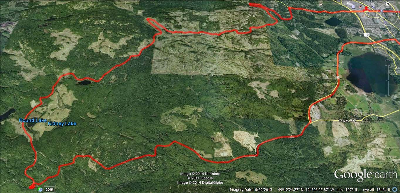 |
| Usual loop, nothing new. Phantom Road to Doumont Road via Kidney Lake... |
Impressed as I am by Andy's time lapse video's via iPod App, I decided to produce a time-lapse video by stitching regular video (MP4) together and then speeding it up... I am using a Coleman Conquest helmet cam which has the option of shooting in MP4 in HD 1080P @ 30fps and shooting continuously while saving files in 1 minute segments which fit together seamlessly when played back (it's called car mode). The advantage of this is that the files can be uploaded or edited quickly if you wish to cherry pick segments from them rather than sorting through one huge file (which you can do if you are glutton for punishment).
So I downloaded Freemake Video and stitched 38 one minute MP4 files together, but stupidly checked the "transition" setting so they fade into each other. I then further complicated things by downloading Go Pro Studio (Free & no malware) to take that single file and speed it up to 6 times speed. So in all this file was converted from MP4, to as GSV file (a go pro tag), an AVI and then back to an MP4... This may have impacted quality, so, for my second attempt, I did the same project again in Go Pro Studio only, to see if the quality is improved with as few conversions as possible.
In Go Pro Studio you can select how many times you want to speed the video up from double speed to hundreds of times...I chose 6. So I'm not sure how a 38 minute video was shrunk to 5m30...that's more like 7 or more times... But it's free, and as me old (Step) dad used to say, "You get what you pay for..."
Attempt Two: Ok this was fun. Go Pro Studio allows you to incorporate slow motion into the vid, controlling it via percentage (100% being normal speed), so I have incorporated a couple of sections of 50% and one of 25%. Given this is a free program, I am very impressed with the flexibility and quality of the resulting product. The downside is that it does take a long time to process the video - my 38 minute video compressed to a 7 minute video in about half an hour...
To improve the quality, maximize the video, click settings and choose HD. Pretty darn good! Oh, and there's a secret message at the end, but don't tell Andy. Oh, and apologies for the music, but it is better than Andy's :)...Again - it was free...
The track for this ride can be found HERE.
[Edit, Aug 21st, Andy]
For a comparison, here's the same ride filmed in time lapse at 4x speed using an iPod and the app "TimeLapse." The last minute is unedited. Sorry--yes, too lazy to edit it properly.
Monday, October 03, 2011
Sundew to Weigles ON A WORK DAY... Life is Good!
Wow, what a ride today! I left work at three thirty today and since there was a bit of sun attempting to poke out from behind the clouds, I decided to attempt entering the Sundew Logging Road in Nanoose via Summerset Road, Sea Blush Drive and Sundew Place.
There's a gate at the start of the logging road, but it's possible to drive through the "work around" on its left side. The logging company has filled a trench with soft sand to prevent entry, but it's fairly easy to blast through it if you keep the revs a bit higher and blast through in one go. :) The road surface on the other side is excellent and once through, you can motor along quite nicely.
Here's my route: (The trail is missing near the labelled bivouac. Google Earth could use an update)!


I really enjoyed this ride. I'd sure like to head back out there one Saturday morning so that I have the time to explore. It was a bit rushed today because I was watching the sun get lower and I knew there were unfamiliar roads ahead of me. It was a relief to see Triumph Lake, (that's right Paul... Triumph Lake), appear on my left and eventually Round Lake. Finally the roads and trails were looking familiar to me. I made the usual turn into the Weigles Road exit and headed towards home. The tank traps are getting worse! The rain is seeing them get more churned up... It was like a quagmire in there. We beginners need a little bit more of the solid muck to grip the tires on you know!
There's a gate at the start of the logging road, but it's possible to drive through the "work around" on its left side. The logging company has filled a trench with soft sand to prevent entry, but it's fairly easy to blast through it if you keep the revs a bit higher and blast through in one go. :) The road surface on the other side is excellent and once through, you can motor along quite nicely.
Here's my route: (The trail is missing near the labelled bivouac. Google Earth could use an update)!
 |
| All photos can be enlarged by clicking on them |


 |
| (Click pic to view) Elevation profile for the green line, (Sundew to "Intersection A"). Max slope of 34.3% is equivalent to about 18°, so not that steep really. |
 |
| The first left turn |
 |
| Looking NE from the bivouac |
 |
| Zooming in on the Islands off Dolphin Beach and Nanoose Peninsula |
 |
| Superb smooth roads for much of the route. |
 |
| Lots of new logging on this road |
And, of course... the obligatory 3D anaglyph photos. These need red/cyan glasses. View FULL.


I really enjoyed this ride. I'd sure like to head back out there one Saturday morning so that I have the time to explore. It was a bit rushed today because I was watching the sun get lower and I knew there were unfamiliar roads ahead of me. It was a relief to see Triumph Lake, (that's right Paul... Triumph Lake), appear on my left and eventually Round Lake. Finally the roads and trails were looking familiar to me. I made the usual turn into the Weigles Road exit and headed towards home. The tank traps are getting worse! The rain is seeing them get more churned up... It was like a quagmire in there. We beginners need a little bit more of the solid muck to grip the tires on you know!
Subscribe to:
Comments (Atom)