Old man winter is getting closer, the sun is getting lower, and, worst of all, my insurance runs out in early December, so today Mother Nature provided us with a respite between systems and me with a bonus ride, albeit a short one. Andy was locked inside in a self-induced purgatorial work-binge and Ryan had no oil in the KTM's sightglass, Ouch. So it was a lone ride today. I like solo rides, and thought I'd stay local (Lantzville Foothills to Nanoose) and look for some new trails. Found some good'uns!
Sundew Main: having a slash when I see three dirt bikes heading north-east, way below. They take a curious trail that I've never seen before. The elevation lets my eye follow them, and I listen to the throttle blips. It sounds good. I follow.
Their tracks and lead to this gate, after passing several looking juicy looking trail junctions on the way. Curious as to where I am, I get the trusty iPhone out. Sywash Ridge Road it tells me. Never heard of it. But handy if you need another route into the foothills/Sundew main...Below, the gap is adequate...
Backtracking from the gate for 80 metres or so, and taking a partially hidden single track path to the right you hit some hydro-lines. I turned left (north-east) and came out to Lorenzen Lane in Lantzville (I know, never heard of it either, but it's off Superior Road). Could've gone right, but it had a more "civilized , dog walking look" , so I decided to leave that for another day.
Turning back, and taking some alternative routes into the woods on the west side of the hydrolines, you get into some great trails with some very tasty side routes...This is FAR steeper than it looks from the wide-angle elevation-flattening iPhone cam....
And another.
Above...Ingrid peeks over the ravine trail...You can see the memorial off to the right. Below, Ingrid-eye view from the top down. There's a slight right hand descending trail across a creek and up the other side. It's a great ride (vid at end of this drivel).
There's a little footbridge across the creek.
Footbridge with trail down from the memorial
Above: Overview of the route; Below: Close up of the Lorenzen Lane and Sywash Ridge Road access routes
Side note. I have to mention the memorial for a young man that I came across. It's a moving tribute to newly married man (August, 2011) called Garrett Paquette who passed away 6 months after his marriage, on November 11th, 2011. He left a grieving wife and an obviously loving family. If you take this route, you will see the moving memorial to Garrett. The memorial was erected for two reasons: one to remember Mr. Paquette, and to "safeguard others not to fall into the ravine below". The ravine is the one I rode down, pictured above.
The fenced entrance, maple tree, and bench serve not only as a tribute to Garret Paquette, but it was also designed to shepherd others across the ravine safely. You can see that without it, it might be tempting ride straight on towards the gently rising and curving trail on the other side of the ravine. This is what Garett did. It cost him his life.
Be safe out there. Ride on the right, and slow down. See you next season.
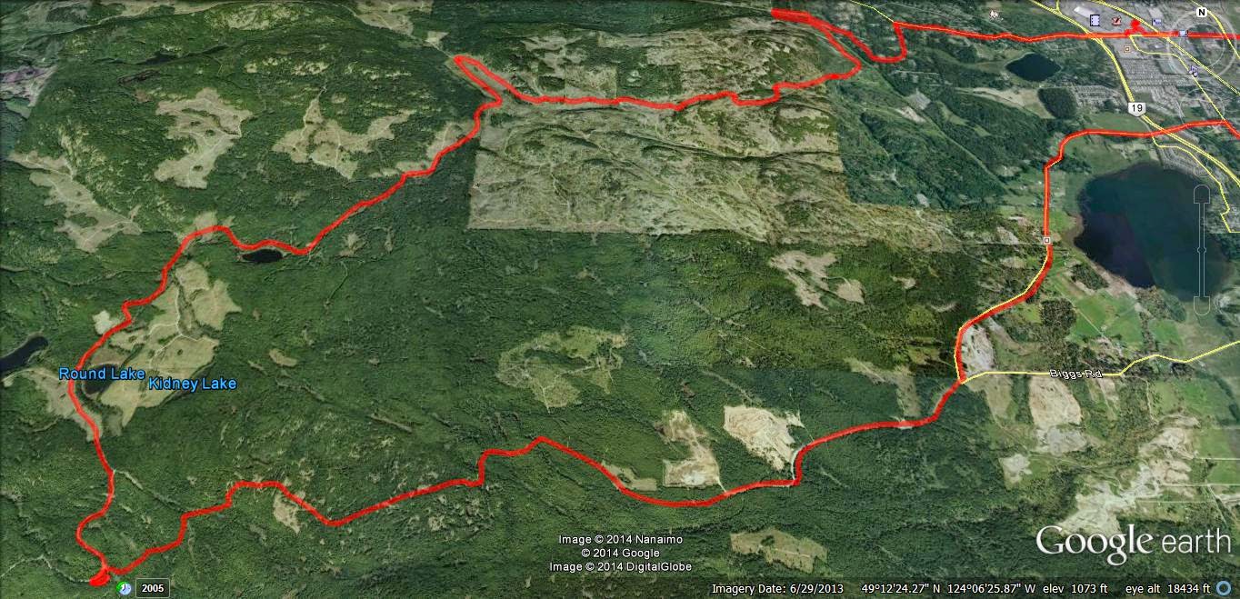
Usual loop, nothing new. Phantom Road to Doumont Road via Kidney Lake...
Impressed as I am by Andy's time lapse video's via iPod App, I decided to produce a time-lapse video by stitching regular video (MP4) together and then speeding it up... I am using a Coleman Conquest helmet cam which has the option of shooting in MP4 in HD 1080P @ 30fps and shooting continuously while saving files in 1 minute segments which fit together seamlessly when played back (it's called car mode). The advantage of this is that the files can be uploaded or edited quickly if you wish to cherry pick segments from them rather than sorting through one huge file (which you can do if you are glutton for punishment). So I downloaded Freemake Video and stitched 38 one minute MP4 files together, but stupidly checked the "transition" setting so they fade into each other. I then further complicated things by downloading Go Pro Studio (Free & no malware) to take that single file and speed it up to 6 times speed. So in all this file was converted from MP4, to as GSV file (a go pro tag), an AVI and then back to an MP4... This may have impacted quality, so, for my second attempt, I did the same project again in Go Pro Studio only, to see if the quality is improved with as few conversions as possible. In Go Pro Studio you can select how many times you want to speed the video up from double speed to hundreds of times...I chose 6. So I'm not sure how a 38 minute video was shrunk to 5m30...that's more like 7 or more times... But it's free, and as me old (Step) dad used to say, "You get what you pay for..." Attempt Two: Ok this was fun. Go Pro Studio allows you to incorporate slow motion into the vid, controlling it via percentage (100% being normal speed), so I have incorporated a couple of sections of 50% and one of 25%. Given this is a free program, I am very impressed with the flexibility and quality of the resulting product. The downside is that it does take a long time to process the video - my 38 minute video compressed to a 7 minute video in about half an hour... To improve the quality, maximize the video, click settings and choose HD. Pretty darn good! Oh, and there's a secret message at the end, but don't tell Andy. Oh, and apologies for the music, but it is better than Andy's :)...Again - it was free...
[Edit, Aug 21st, Andy] For a comparison, here's the same ride filmed in time lapse at 4x speed using an iPod and the app "TimeLapse." The last minute is unedited. Sorry--yes, too lazy to edit it properly.
As you can see from the previous five excellent posts, The REAL Motorcycle Diaries and DR Siouxsie's Travels have joined forces. Paul and I have decided to manage this page between us and to pool our resources since we often ride together anyway. This way, you get to read my hard-hitting, straight-to-the-point riding facts while enjoying Paul's verbose clatter sometimes in the same post! Speaking of verbose clatter, here's a mindless post that's sure to lull any reader into a deep sleep:
I've been playing around with timelapse videos on my ipod once again. (The resolution is crap, especially after YouTube have taken their bite out of it, but it serves its purpose quite well). I just set my bike up with a 12v/5v accessory plug in and I wanted to get out there and give it a whirl. So, here's a video to further illustrate my last post "Two Doumont Gates that Lead to Bonnell Main (The Sundew Road)". This video ride was identical to the previous post, except that I exited onto Harwood Dr., instead of returning to a Doumont gate, using a short and easily navigable workaround. (The tracks for this ride, including the workaround, can be found here).
The Route:
1. Entered through yellow gate off of Doumont Road 2. Over the white bridge and next left up the hill 3. Through the "Mud Pass" into the Lantzville Foothills 4. U-turn at Bonnell Main 5. Left towards alternate exit 6. Exited onto Harwood Dr. using workaround. (Harwood Dr. is very close to Phantom Rd., giving a couple of options in this area)
Here's the workaround at #6 above. It has been posted on here before, but with all the recent blockages by Tim Berwest, I thought it would be good to show that it's still open. (Go on Tim--do your worst. You know you wanna).
Now, the video you've ALL been waiting for.... *yawn*:
Okay Tim Berwest -- here are a couple more gates for you to block! To the more civilized visitors, here are a couple of gates, (1 and 10 on map), that will still get you into the logging roads, (to Bonnell Main):
1. Begin at the first gate on Weigles Rd. to appear on your right after Doumont and Biggs meet. It's the one that's slightly off the road... about 100yds or so. Currently, you can scoot in the right side of this gate.
2. Take a left at the first major Y in the road (Get the GPS track here. There are a few twists and turns).
3. Turn right on the brand new dirt logging road and follow it straight to a slightly overgrown trail. Careful in the wet... There are many small downed trees/logs across the road on this trail.
4. Trail slims to a barely visible walking type trail with exposed roots here and there.
5. Enter the Foothills Trails.
6. Through the usually open red gate.
7. Bonnell Main Intersection. You`re on the logging roads!
8. Retraced track to a left turn Y, a small trail that leads back through the university trails to Doumont Rd.
9. Over the white bridge.
10. Doumont Gate
Recent activity by TimberWest has sprung up at the Doumont Rd entrance to the logging roads once again, creating yet another challenge for local recreational riders wanting to enjoy the local lakes and surrounding areas. The popular entry point of the tank traps was dug up and blocked some weeks ago and local riders managed to successfully blast their way through it. TimberWest has responded with yet another attempt at blocking this regularly used entrance. :
Earth mounds placed at the exit point where the last ditch was (Facing towards logging road)
Deep trench replaces last attempt of rock line (Facing logging road)
Deep trench replaces rock line (Facing away from logging road)
New mound at side entrance
Trench
I'm afraid it's not going to work TimberWest! Maybe something more like this is needed.
It was a mixed bag of rides today. I've been looking at a photo on Google Earth that Paul took entitled "Old Logging Terminus" and I've been wanting to get up there and check what looks like an outstanding view of the Winchelsea Islands. The same array of logging road spurs takes you up to a couple of smaller lakes in the area that I've been curious about, so for part one of today's ride I planned to search out the spurs and take in the lakes and the ocean view.
Part two was intended only to check out the location of the Lantzville foothills gate. I assumed it would be locked since entrance to this area is always gated from the Doumont entrances. To my great surprise and even greater pleasure, it was open! I went through, explored a spur and rode a beautiful trail to the Vipond Road gate. Details posted below in the photos.
Here's the route:
1. Entered at Doumont Trail, through the Tank Traps and on past Round Lake.
2. Turned left and began exploring network of spur roads, (blue shaded oval).
3. I was disappointed with the lakes... both are strewn with fallen timber and have little access for fishing. Forgot to snap a picture. :( They're not stocked with trout of course. I'm dubbing them "The Crap Lakes." Fun trails all around... lots of ups and downs. Tons of logging; over logging really--quite sad.
4. This is a fantastic location! The view of the Winchelsea Islands is superb. Like an idiot, I brought my digital camera, but it had difficulty writing the data to my memory card that was sitting on my computer at home. Must go back and take more... I had to settle for Garmin's navigational snaps this time around. Could be worse; these photo are set at Garmin's highest resolution of 5MP.
5. Back onto the main logging road, The Sundew Main Connector, and then a sharp right onto the Lantzville Foothills entrance road.
6. Rode this fun little uphill spur road.
7. Reached the ominous gate into the foothills. I took a few minutes to walk around and check for any possible work-arounds: No chance--they have that area locked down like a full-security prison, but as I said in my opening paragraphs, it was open today!
8. Took a left at the upcoming Y and proceeded up a really nice trail. The ground changes to a red clay base out in the foothills direction and the riding surface is either smooth clay or chunks of rock thrown down by the logging road graders. Very steep here and there... I turned around on one of the hills and decided to go looking for a route through the foothills towards any available Doumont gate. Could it be open too?
9. This was a fantastic older logging road. Twisty and hilly with a firm base of mainly packed mud/clay with many grassy spots. The large chunks of rocks are always about on the hills though, thanks to the logging co.
10. Arrived at Vipond Rd. gate. It was locked of course, but easy to get around.
A wee bit of perspective
The fantastic Winchelsea Islands view spot, (Paul's "Old Logging Terminus.") The white line on the coast over the water is the town of Sechelt on Vancouver's sunshine coast.
A panoramic image of the same area
Along one of the spurs out towards "Crap Lake"
More spurs in the same area. No trees around there. :(
Open Sesame! The Lantzville Foothills Gate
The red trails of the Lantzville foothills
Red again... It's like Mars out there.
Exiting at the Vipond Rd. Gate. I was a little worried that if I wasn't able to get through this one, I would have to retrace my steps and possibly meet a closed gate on the other side where I had entered. It was close to 6pm and they have a habit of locking things up around 5pm in some areas. It was a pretty easy work around at this end though. Gotta love that sign! :)
Some kind individual must have buggered up their "keep-out" chain with a truck. Easy as pie.
40.2 Km... I was completely knackered with the beautifully hot sun we've had all day! I need to sort out a summer riding jacket to content with the heat out there.
Great ride. I want back in there to explore some more trails.
"Speed" on left, "Elevation" on right and "Distance" on the horizontal. "Elevation" line in green and "Speed" line in blue. I know, I'm slow.... What can I say?
Wooohoo, there's a window appearing in the local weather. It looks like a rain free day... perfect for a quick ride out to the Nanaimo Lakes area. Nanaimo has a series of lakes that run west from the south end of the city. The area is owned by a large logging company who open their gates on weekends for campers to travel the logging roads into campsites on the lakes. I was heading for Fourth Lake today, the last of the Nanaimo Lakes, to try some fishing off the dam if possible.
The route (Click to enlarge)
I picked the route heading south behind Mount Benson to keep it interesting rather than heading through the city. I entered the logging roads through Weigles Road and headed through the worsening gummy tank traps. (I got my bike stuck in a pool of sludge going through there today). I followed the route I had taken on an earlier ride with Paul, past Boomerang Lake and down to the locked gate that exits onto Nanaimo Lakes Road. The work-around is to the right of the gate and leads through a series of hills and pools that have been pretty overrun by quads that like to churn up the mud.
The "work-around" to the right of Nanaimo Lakes Road gate
The gate "work-around"
After ten minutes of navigating on foot to check if parts were passable I emerged onto Nanaimo Lakes Road and made my way on real roads to South Forks Rd. This road takes you directly to Nanaimo River Road, the stretch of road that leads to all of the lakes.
Some miles along you reach an opened gate. There was a gate keeper there today, as there is on most weekends, and he took my name, address, phone number and licence number. I was instructed to check back out before five-o-clock.
First Lake is just beyond the gate. I could see trout swirling around near shore and I wish now that I'd taken the time to stop there to fish for a while. I wanted to move on and try fishing at Fourth Lake and still get out by five so I went on.
Second Lake
The logging roads are in great shape all the way through the lakes area. I wouldn't take a regular car through there, but it's quite manageable for a 4x4 truck or trail bike. After a few turns, approximately 30 minutes after passing the gate guy, I reached a Y in the road and a sign pointing left to "Fourth Lake." The lake is only a few minutes ahead after climbing a small hill.
Left for Fourth Lake.
I turned right at the lake and drove along the length of the dam itself. You can't fish easily off the dam, but there are many spots visible along the shore nearby. I rode off towards the end of the Fourth Lake campsite and found a good spot on the lake shore for fishing.
The far end of the dam
Looking along the dam towards the road. That's my fishing spot on the shore near the yellow tree furthest to the right.
Taken from the dam looking SW
Cheesy self-timer shot off the dam wall.
Further round the lake... This is the campsite area. I fished from this spot. That's the dam on the left.
The dam
Looking SW down the lake
I fished for about forty minutes and got many hits but I only managed to pull one in, a tiny trout that I was determined to keep.
The monster of the lake
I followed part of the same route home, but this time I opted for a trip through the city because it started to rain. Altogether it was a really good ride and one that I'll repeat again. Next time I think I'll stop at First Lake to do some fishing though.
That was five hours of wicked entertainment, traveling 140Km through some fantastic terrain, and the whole thing cost me $5.80 in fuel. Not bad value since I brought a fish home too. ;)


.jpg)
.jpg)
.jpg)

.jpg)

.jpg)
.jpg)


.jpg)
.jpg)