
Showing posts with label dumont. Show all posts
Showing posts with label dumont. Show all posts
Tuesday, June 14, 2016
Saturday, September 06, 2014
Time Lapse Vid of Doumont to Bonnell Main New Route
Ok, it took me a nearly a week to produce this video as the much vaunted free software I raved about last week (GoPro Studio) has developed a bug. I lost the entire 3 hour production two days ago as it crashed. Since then, and while re doing the video, it crashed every ten minutes. I have re-installed, rebooted without success. Like me old step dad said, "you get what you pay for"...Don't forget to turn the settings up to HD. If you don't like the music, no complaints...just mute it :)
The video references points on the map below:

The video references points on the map below:
The ten minute epic...
Monday, September 01, 2014
Foothills to Bonnell Main - Alternative
 |
| (Click to Enlarge) GPX File HERE |
2 Steepish gulch, winds through trees. Could be muddy in wet weather. Surface is sandy duff. Ends in potentially boggy area. Little technical, but fun.
3 Right goes to Vipond, left to some interesting trails and new access to the Bonnell Main logging road.
4 Right goes to the more traveled Foothills trails and eventually to Phantom or, if you wish, to (6) the open red gate to the Sundew Main logging roads.
5 View point spur. Steep decline onto a vista where you can see the red gate across the valley. Scenic. Fun to ride.
6 The popular route into the Sundew Main Logging roads.
7 Steep incline on your right.
8 Overgown lake, now a reedy bog. Scenic, especially if you climb up the outcrop where you will see the NW Bay logging area on the other side of a small fringe of trees.
9 Descends into a single track alder trail, which may continue into the promised land...or not.
10 Access to Bonnell Main via an easy burm and small sandy single track trail through a small fringe of trees left by the logging company.
11 Bonnell Main (Goose Corner if you look at the associated photograph on GE). From here NW Bay is your oyster.
12 Viewpoint over Nanoose Bay, Maude Island etc. Nice small BBQ too!
13 Steep but fun ride up the "loop".
14 Red dirt descent. Again "fun".
15 Active quarry operation. Keep out. Let's not vandalize here and get our access blocked please...
16 Vipond Road Gate. Locked. No easy work around. A small ramp would work as the gate is low. But why? Head back past 15 and continue north to Phantom or Harwood Roads.
17 Rewarding connector back to gulch. Try this on your pegs, weight forward, clutching and at jogging speed in the dry. In the wet, make sure you have a trials tire on the back.
All in all this was a great ride! A few B level technical trails, but nothing to stop a dirt bike and average rider. Mostly, just great fun and as fast as you like. Watch for other riders, keep right and stop to look at the views.
Time Lapse Video is here...see more recent post...Explanation for late arrival in detail! (Couldn't get rid of the art below...too funny).
Paul.


Saturday, August 16, 2014
Go Pro Studio...Take One & Two
 |
| Usual loop, nothing new. Phantom Road to Doumont Road via Kidney Lake... |
Impressed as I am by Andy's time lapse video's via iPod App, I decided to produce a time-lapse video by stitching regular video (MP4) together and then speeding it up... I am using a Coleman Conquest helmet cam which has the option of shooting in MP4 in HD 1080P @ 30fps and shooting continuously while saving files in 1 minute segments which fit together seamlessly when played back (it's called car mode). The advantage of this is that the files can be uploaded or edited quickly if you wish to cherry pick segments from them rather than sorting through one huge file (which you can do if you are glutton for punishment).
So I downloaded Freemake Video and stitched 38 one minute MP4 files together, but stupidly checked the "transition" setting so they fade into each other. I then further complicated things by downloading Go Pro Studio (Free & no malware) to take that single file and speed it up to 6 times speed. So in all this file was converted from MP4, to as GSV file (a go pro tag), an AVI and then back to an MP4... This may have impacted quality, so, for my second attempt, I did the same project again in Go Pro Studio only, to see if the quality is improved with as few conversions as possible.
In Go Pro Studio you can select how many times you want to speed the video up from double speed to hundreds of times...I chose 6. So I'm not sure how a 38 minute video was shrunk to 5m30...that's more like 7 or more times... But it's free, and as me old (Step) dad used to say, "You get what you pay for..."
Attempt Two: Ok this was fun. Go Pro Studio allows you to incorporate slow motion into the vid, controlling it via percentage (100% being normal speed), so I have incorporated a couple of sections of 50% and one of 25%. Given this is a free program, I am very impressed with the flexibility and quality of the resulting product. The downside is that it does take a long time to process the video - my 38 minute video compressed to a 7 minute video in about half an hour...
To improve the quality, maximize the video, click settings and choose HD. Pretty darn good! Oh, and there's a secret message at the end, but don't tell Andy. Oh, and apologies for the music, but it is better than Andy's :)...Again - it was free...
The track for this ride can be found HERE.
[Edit, Aug 21st, Andy]
For a comparison, here's the same ride filmed in time lapse at 4x speed using an iPod and the app "TimeLapse." The last minute is unedited. Sorry--yes, too lazy to edit it properly.
Saturday, July 26, 2014
Two Doumont Area Gates That Lead to Bonnell Main (The Sundew Road)
Okay Tim Berwest -- here are a couple more gates for you to block! To the more civilized visitors, here are a couple of gates, (1 and 10 on map), that will still get you into the logging roads, (to Bonnell Main):

1. Begin at the first gate on Weigles Rd. to appear on your right after Doumont and Biggs meet. It's the one that's slightly off the road... about 100yds or so. Currently, you can scoot in the right side of this gate.
2. Take a left at the first major Y in the road (Get the GPS track here. There are a few twists and turns).
3. Turn right on the brand new dirt logging road and follow it straight to a slightly overgrown trail. Careful in the wet... There are many small downed trees/logs across the road on this trail.
4. Trail slims to a barely visible walking type trail with exposed roots here and there.
5. Enter the Foothills Trails.
6. Through the usually open red gate.
7. Bonnell Main Intersection. You`re on the logging roads!
8. Retraced track to a left turn Y, a small trail that leads back through the university trails to Doumont Rd.
9. Over the white bridge.
10. Doumont Gate


The GPS track for this ride can be found here.
1. Begin at the first gate on Weigles Rd. to appear on your right after Doumont and Biggs meet. It's the one that's slightly off the road... about 100yds or so. Currently, you can scoot in the right side of this gate.
2. Take a left at the first major Y in the road (Get the GPS track here. There are a few twists and turns).
3. Turn right on the brand new dirt logging road and follow it straight to a slightly overgrown trail. Careful in the wet... There are many small downed trees/logs across the road on this trail.
4. Trail slims to a barely visible walking type trail with exposed roots here and there.
5. Enter the Foothills Trails.
6. Through the usually open red gate.
7. Bonnell Main Intersection. You`re on the logging roads!
8. Retraced track to a left turn Y, a small trail that leads back through the university trails to Doumont Rd.
9. Over the white bridge.
10. Doumont Gate
A quick overview of the track on video
Panoramic photo of the Lanzville Foothills area
Lantzville Foothills
The GPS track for this ride can be found here.
Saturday, October 27, 2012
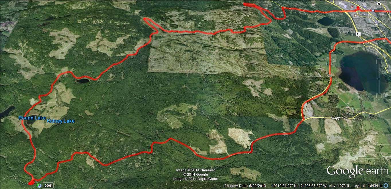
Kidney Failure Lake
Nanaimo is lucky enough to have two Kidney Lakes. Don't ask me how that happened! Perhaps it was some cartographer's bad joke at attempting an anatomically correct map, or perhaps it was the more likely result of general confusion on the part of loggers and other visitors. Anyway, we have two--and one has remained a mystery to me for all this time since the local logging company closed off the main entrance to this region some time ago. (Why they ever did this raises a few questions too. Kidney Lk. II is such a buggered-up mess of dead logs, I have to wonder if they're saving the embarrassment of people actually finding it. Maybe not, they have gone to the effort of leaving a scabby, thin boundary around it to maintain its pristine healthy look. FfffPbwaaahahaha).
I've attempted to find Kidney Lk. II a few times using trails from the east side that run through the university's excrement infested trails, but I've had little luck until very recently. One riding friend, Sebastian, located the hidden trails a few weeks ago and his success was followed up recently by Paul who discovered Sebastian's route in from the Doumont Trail shortly before the "tank traps." I came crawling along in third place to claim my own victory, although I did need Paul's poxy GPS track to actually get in there.
Here's the route:
1. Beginning of Dumont Trail at the shot up "No Dumping" sign
2. Turned right shortly before the tank traps (This is at the first big pool in the road during the wet season. It's the road pool that most bikes avoid by taking the shortcut to the left to eliminate the pond and the entire wet corner). Actually, there's another right you can take 100m before you get to this one.
3. You have some choices here. It is possible to avoid the steep hill and the awkward trenches. I like to go right at the wreck (to avoid the hill), next left to the bottom of the hill and then just follow the serpentine along to your right until you reach the logging roads.
4. Rode through the logging roads using the old maze solution: always turn left until you're out. This brought me close to Kidney Failure Lake really quickly, so I rummaged through the undergrowth to get a photo, (see below).
5. This road passes above Round Lake. I'm not sure it's worth the hike down, since you can get there easily from the Sundew Main road on the other side. There's fish in there, but it's not one of the better local lakes.
6. I took a good look at the road block that I often pass from the other side. It's a complete mystery why they went to the bother of blocking this route through. I'm sure it was well planned and extremely necessary to ensure good environmental logging practice though. ;)
7. Stopped off to view the "lake" from this side too, (see photo below).
8. Did this loop for absolutely no reason at all.
9. Turned left at an entrance into the uni lands near the concrete pad (truck loading point) to follow a known trail that exits near the Biggs/Dumont intersection.
10. If you turn right here, on what looks like the main trail, it comes to a dead end. Go left when travelling east. (It's weird riding this trail in this direction. I always come up it the other way).
11. Found myself at the backside of a well-secured yellow gate.
12. The white bridge and exit gate to Dumont.
Some Photos:
Nice to finally get in there and check the place out!
I've attempted to find Kidney Lk. II a few times using trails from the east side that run through the university's excrement infested trails, but I've had little luck until very recently. One riding friend, Sebastian, located the hidden trails a few weeks ago and his success was followed up recently by Paul who discovered Sebastian's route in from the Doumont Trail shortly before the "tank traps." I came crawling along in third place to claim my own victory, although I did need Paul's poxy GPS track to actually get in there.
Here's the route:
 |
| The Route (Click Image to Enlarge). |
2. Turned right shortly before the tank traps (This is at the first big pool in the road during the wet season. It's the road pool that most bikes avoid by taking the shortcut to the left to eliminate the pond and the entire wet corner). Actually, there's another right you can take 100m before you get to this one.
3. You have some choices here. It is possible to avoid the steep hill and the awkward trenches. I like to go right at the wreck (to avoid the hill), next left to the bottom of the hill and then just follow the serpentine along to your right until you reach the logging roads.
4. Rode through the logging roads using the old maze solution: always turn left until you're out. This brought me close to Kidney Failure Lake really quickly, so I rummaged through the undergrowth to get a photo, (see below).
5. This road passes above Round Lake. I'm not sure it's worth the hike down, since you can get there easily from the Sundew Main road on the other side. There's fish in there, but it's not one of the better local lakes.
6. I took a good look at the road block that I often pass from the other side. It's a complete mystery why they went to the bother of blocking this route through. I'm sure it was well planned and extremely necessary to ensure good environmental logging practice though. ;)
7. Stopped off to view the "lake" from this side too, (see photo below).
8. Did this loop for absolutely no reason at all.
9. Turned left at an entrance into the uni lands near the concrete pad (truck loading point) to follow a known trail that exits near the Biggs/Dumont intersection.
10. If you turn right here, on what looks like the main trail, it comes to a dead end. Go left when travelling east. (It's weird riding this trail in this direction. I always come up it the other way).
11. Found myself at the backside of a well-secured yellow gate.
12. The white bridge and exit gate to Dumont.
Some Photos:
 |
| Paul's earlier track in red and my earlier (failed) attempt to get here a week ago in pink. (There's a nasty hill where the red and pink join that made it impossible for me to get through from that direction. I walked it). |
 |
| The wreck mentioned at #3. Left for the hill and right to avoid it. |
 |
| (Animated gif) A 4x4 truck on his fourth attempt to make the steep hill. He did well considering his tires weren't that chunky. |
 |
| Panoramic view of Kidney Lk II |
 |
| Beginning of the asinine road block between Sundew Main and the Kidney Lk II area. |
 |
| Peeking at the north-east end of the lake at location #7. Sorry... crap shot! |
 |
| Returning at point #3. I went left. |
 |
| Returning at #3. I went left again... Right is okay until you wipe out into the trench. :) |
Nice to finally get in there and check the place out!
Subscribe to:
Comments (Atom)