We needed a short local ride today to seat Paul's brand spanking new D606 rear tire. What better than a quick ride up and over Blackjack Ridge to get the job done.
Here's what we did:
1. Entered at Doumont Road
2. Through the Tank Traps and a left turn towards Boomerang Lake
3. Left again towards southern end of Boomerang
4. Past S. end of Boomerang and then straight along the N.E. side of Blackjack Ridge towards Lucid Lk.
5. Right turn after Lucid Lake
6. Climb up creekbed towards top of Blackjack
7. Explored dead end spur
8. Through open gate at the top and explored dead end logging road to our right
9. Right turn onto untried route (went straight on previous trip up here)
10. Downhill creek bed for a fair way here. (approx 3km)
11. Rotten log make-shift bridge (Hurry before it's all gone)
12. Left turn at the main logging road
13. Return on same route to Doumont Rd.
Photos:
The descending creek bed at #10. We walked this for a short distance before deciding to go on.
The makeshift bridge of half-rotten logs at #11.
Other "Real Motorcycle Diaries" blog entries containing search criteria "blackjack." (There are some better Blackjack shots in these entries).
Here's today's GPS track on video. Realtime x100. (Best viewed at 700p/full screen).
Fun ride, but only once so you can say you did. It's not horrendously difficult, it's just slow going for much of it when going through old creek beds. My clutch wasn't very happy. :) Likely quite slippery in the winter!
I've ridden the trails up around Blackjack Ridge a few times now. The views up there are amazing and it's always worth heading that way if I just have the time for a local ride. But, every time I head up I stop at the same steep rocky section that heads over the top, leading eventually to the trails near Lucid Lake and the lower road that runs the SW side of Mount Benson. I decided this time around to come at it from the Lucid Lake side, with a plan to turn back if the rocky, steep section looked too nasty from the top end.
Here's the route:
1. Entered at Doumont
2. Left towards Boomerang
3. Left again
4. Pass Boomerang and keep left
5. Continued along length of Mt. Benson and turned up road that leads to Lucid Lake
6. Followed creek bed leading up Blackjack Ridge.
7. Through new gate. (Logging roads look very new up here)
8. Best view on Blackjack Ridge, overlooking Nanaimo Lakes
9. Another nice spur road with an outstanding view
10. The steep rocky section... heading down this time
11. Descent towards Boomerang Lake
12. Out
The uphill creek bed at #5
The creek bed continues like this for about a kilometer
New logging gate at #7. A few newer logging roads connect up here.
180° Panoramic view looking SW from the best view location on the ridge (#8).
Nice section of spur trail (#9).
A shot along the power lines at #9
Just past this location the road begins a steep descent towards the spot where I decided against continuing on previous rides (#10). It's a great deal easier going down, although there are a few spots where I slowed to a miserable crawl. No pic unfortunately... It's funny how the thought of photos disappears when your watching your front tire so carefully. :)
First and Second Lake from location #8
Great ride. I want to return to look at the lake just 0.7 km east of location #8. Google Earth shows an unnamed, frozen-over lake about half the size of Round Lake. Next time!
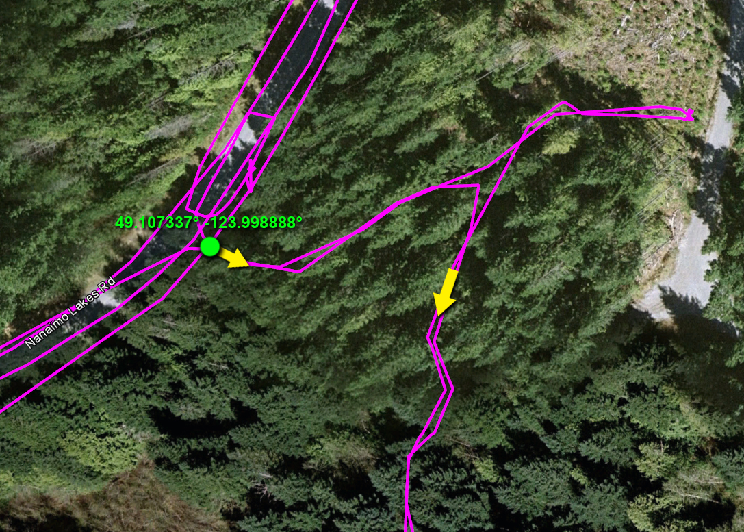
I took a short ride to find the old Beban Coal Mine today. I entered at Doumont Trail, rode Blackjack Ridge's lower valley to Nanaimo River Road and made my way on blacktop up to South Forks and Nanaimo Lakes Road to find the entry gate shown at the top of the light blue line.
Dark blue - Logging Road that Runs the length of Mt Benson (SE, rear
side). Light Blue - Intended route entering from Nanaimo Lakes Road.
Pink - My GPS track
The gate was very well blocked with large rocks and so I made my way
SE, looking for a way in. I eventually found a narrow gap between two
rocks at 49.107337° -123.998888° and continued south to the mine site.
My entry point into the trails
The mine site - letters correspond to the photos below:
a. I'm not sure what this is, although it looks like nothing more that a shelving unit, (feet on left side). It's in very good condition and looks to
be a little too new to be a mine site artifact, although there is little other reason for it to be there. Probably Beban's personal Scotch whisky stash. None left! :(
b. Threaded rods protruding from a building foundation
c. Difficult to see here with the thick undergrowth all around. This is a deep vertical shaft. It's marked off with a scrawny bit of lumberman's tape
d. Deep Shaft
e. Same deep shaft. Very loose ground and a very deep hole, so this is the best I can do I'm afraid. :)
f. This is the same shaft, but I backed up to see the marking tapes.
g. Chunk o' anthracite coal. Lots of this stuff kicking around
h. Remnants of some old piece of equipment
i. The obligatory junked car photo.
j. Tailings pile
k. (no photo) Another shaft... filled.
It struck me after I had left the site that the original "Beban Mine" waypoint that I lifted from Wikipedia, (seen on the photo with all those yellow letters above), is likely the location of another shaft. The Beban Mine was in the news during the sixties when a boy had ventured into the mine and was unable to get out. He died in the mine. This mine, as I understand it, went in off a slope, and I'm guessing that had I searched this Wikipedia waypoint I would have found that shaft. GOOD... I have a reason to return on another ride!
**BE WARNED: If you head into this area, keep your eyes fixed on the ground. There are numerous vertical shafts and all are covered with thick undergrowth during the spring and summer. It looks like logging crews have marked trees for cutting or leaving, but aside from their tape, little has been done to call attention to the shafts. In addition, the ground is loose and crumbly near shaft edges. Be careful! ;)
We just returned from a three day tour of local logging roads in the Cowichan Lake Valley, Nitinat Region and Alberni-Clayoquot region. Fantastic trip!
Brief Summary:
1. Entered at Doumont Rd
2. Followed Blackjack Ridge
3. Turned away at First Lake Gate
4. Took alternate (boring) highway route to enter logging roads at Youbou
5. Right turn towards Cowichan Lake
6. Gassed up in Youbou
7. Turn for Marcus Lake
8. Explored Spur and enjoyed watching Paul extract a week old, rotten banana from his pack
9. Camp (Marcus)
10. Day 2: Hike up to find B24 Liberator wreckage
11. Camp (Flora Lake)
12. Franklin Camp (Leveled Town)
13. Major Logging Road into Port Alberni
14. Civilized lunch!
15. Explored roads looking for a route through to Lk Arrowsmith
16. Qualicum Beach
17. Entered trails at Sundew Gate
18. End at Doumont
We planned to enter at Doumont and make our way past Fourth Lake, following a common route to Cowichan Lake. It didn't go as planned: We got as far as the Second Lake gate where the usual gate controller stopped us. Camping at the nearby lake site was open, (for $20), but access to the logging roads beyond the lakes was not. Apparently there is no access during working days, although access to the area beyond the lakes was to be available tomorrow, (Saturday), for all weekend traffic. This was a huge disappointment for us, because our only alternative was to take the highway south to Cowichan Lake and enter the same logging road network via Youbou. This is what we did.
We gassed up in Youbou and continued on our way to our first major destination, Marcus Lake, with a plan to set up camp and do some trout fishing. We were both impressed with the condition of logging roads throughout this region. The main busier gravel roads are dusty and potholed, but they're in good enough shape to make some pretty rapid headway. It was a Friday, and working logging trucks were using the road. We were both impressed how they make a real attempt to pull over to give oncoming non-working vehicles a wide berth. They kick up a tremendous amount of dust when they pass!
We turned right along the Marcus Lake logging road and continued an increasing climb towards our destination. We were both impressed by the quality of this road and how a mountain spur should differ so much from the rocky roads found in the Nanaimo region. This road became quite steep as we got closer to the lake, and the ride remained very easy throughout.
Waterfall Enroute to Marcus Lake
We stopped at the steepest section where a back hoe operator was conditioning the road surface. It looked difficult to climb in it's current state and we chose to continue on foot to get a look of the lake. The worker, who had waved us on before we parked, shut off his equipment and assured us that the road would be rideable within the next half hour. (Friendliest logging worker I've met yet). :) Outstanding views towards Nitnat Lake here.
160 Degree Pano facing Nitnat Lake
Paul extracting a rotting banana that was seeping through his pack after weeks of careful storage
Excellent Mountain and Valley Views
We continued along a spur road that offered some tremendous mountain views. It eventually came to a dead end as did the second spur we found along that route. We returned NW towards Marcus Lake and began our hunt for a good camping spot. There are few on this lake and we eventually settled for the best one we could find; a little boggy and mosquito infested, but it would have to do. Not a great first night for me. I guess it's a poor idea to begin a three day camping trip with no breakfast except for a SBuck's dark, black coffee. I had severe acid indigestion that kept me up the whole night. Poor fishing here... a trout breakfast might have fixed me up! :)
We were packed and loaded by 9:00 and ready to begin leg two of the trip. We headed south, back the way we had entered and followed the Nitnat Main towards the B24 (Liberator) bomber crash site, (Crashed Nov 10th, 1944), that we had seen on "Don's Blog." [edit: Sept 7th, '14, removed Don's Blog link due to malware warning]. This was a great ride up to the crash site. The road is steep, but the surface is in good condition and riding is easy. There are a few drainage ditches towards the end of the road that take some concentration, but generally speaking this is an easy-intermediate ride. I'm surprised we didn't bump into any bears since the road is littered in places with bear crap. We parked at Don's spot and began our climb up the mountain to find the bomber.
Some background on this plane:
B-24J Liberator Serial Number KH-108 Code AT, was on a cross-country training exercise with crew of 11 RAF in Operational Training for RAF Squadrons in S.E. Asia and Burma:
I'm so out of shape! That was the toughest climb I have undertaken in quite a few years. We made our way through large, dry stumps and low undergrowth on steep terrain for about 180m and then began a climb up steeper ground using small bushes as "ropes." :) My recovery time was doubling each time I stopped and the distance traveled between each rest was being cut in half. The site was well worth the climb though: We found many of the locations shared by Don on his blog and some others he had not listed, including the main part of the fuselage that sits on the summit reachable by following debris up the mountain from the prop location.
Here's a quick movie of Google Earth views of the surrounding area to give a better idea of the plane's location. The B24 is at the end of the orange trail of course and not right where it says "B24 Bomber."
The amount of damage to this aircraft is astonishing. There are parts spread across the entire mountain top, particularly along one side where the prop can be found. Those aboard surely died very quickly judging from the carnage.
It's time for a bit of a rant here: [on soap box] War sites like this fill most of us with a feeling of great respect for the individuals who lost their lives serving their country. Why people find it necessary to scrape their names into the last remaining signs that these people ever existed absolutely boggles my mind. One name scraper bothered to say "rest in peace," while others made inane comments about guns or just left a name. In my mind, we visit these places to remember those who perished, rather than giving ANY significance to our own name. WTF, I don't care that Tom Smith was there and nor should he. It's self-flattery to think that anyone should give a shit that you ever visited there! See it... Acknowledge them kindly... Leave with nothing. [off soap box]
After descending the great trail leading to the bomber, we took a right turn towards Flora Lake and set up our tents for the second night. This was a great camp site: a free provincial site with a good collection of firewood. We should have spent our first night here I think; much more comfortable and we got the trout breakfast we had missed at Marcus Lake.
Flora Lake Camping
Flora Lake Looking North
The following morning we continued towards Francis Lake and Franklin Camp. The lake was right beside the logging road... well used, with a large wide boat ramp. I guess it's far enough away from any big towns to keep from being too busy, but it didn't look that appealing to me anyway. Franklin Camp is nothing more than a levelled 1960s small logging town. All that remains is what looks like a water/fuel oil storage tank and the collapsed wreckage of one house at the far corner of town, (just junk left). The alders are quickly reclaiming the roads and deer are already moved in. Satisfying to say that we made it to Franklin Camp, but really nothing to see there. It would make a great go-cart course! :)
A Better Street in Franklin Camp
Works Area: Franklin Camp
Looking Towards the Residences (Streets)
From Franklin Camp we continued north on the main logging road that passes through China Beach camping area towards Port Alberni. We stopped in Port Alberni for a civilized lunch before moving on north west towards Cameron Lake. Paul had hatched an idea to follow a network of logging roads that begin travelling south shortly after passing Cameron Lake. The plan was to connect with the Englishman River Main, a logging road we know, by passing Arrowsmith Lake.
Looking Back Towards Cameron Lake
Too bad it didn't pan out: We tried a few roads that either became impassable or were dead-end spur roads. We returned the way we had come and used the main roads towards Nanaimo instead. Paul headed straight home to tend to an emergency and I sauntered through Qualicum Beach, Parksville, Nanoose and eventually passed through Sundew Gate and rode to Doumont Rd using much more familiar roads. What a great trip. Time for a shower!
I managed to convince myself that it was only the snow at higher elevations that prevented me from blasting over Blackjack Ridge towards Lucid Lake and Mt. Benson last fall. I had my memory corrected today while facing the familiar steep and boulder strewn logging road ahead of me. "I'm not going up THAT!" I'll leave this one for Paul to sail up.
Here's today's after work ride:
1. Entered at Doumont Trail
2. "Intersection A" Left toward Boomerang Lake
3. Continued straight past Boomerang on familiar "Behind Mt. Benson" road, but turned right shortly afterwards to begin the climb up Blackjack Ridge's upper road.
4. Made the same stop as last time, turning right onto a short spur road that offers amazing views at 711m. The Blackjack Ridge road begins a steep climb where this spur begins. I rode up it for about twenty feet and decided I had better leave this one for another day. (Maybe when/if I lower my bike????)
5. Turned right, on the way back, up this fantastic narrow windy trail that leads to the Benson Trail. Followed the Benson Trail back to Boomerang Lk. (Had a quick peep to see if Paul was fishing up the lake... Not).
6. Lake intersection
7. Dropped in at Kidney Lake and fished for an hour or so. Nice trout.
150° Panoramic - Mid way up the trail that heads up Blackjack Ridge. The trail directly behind my bike winds its way along the ridge and offers amazing views. I didn't ride it this time, but it's a great addition to the ride if you're looking for photos. That's Mt. Decosmos in the distance with Mt. Hooker on it's left. (First lake lies between them).
209° Panoramic - This is the end of the road at location #4. Mt Hooker (left) and Mt Decosmos in the Background. First Lake is clearly visible in this photo in the foreground of Mt. Hooker. (If you click on the photo).
In the distance lies Mt. Whymper. (Looking left of Mt. Hooker). Crappy name for the biggest mountain out that way!
First Lake - Mt Hooker (right) - Mt. Whymper (distant left)
The power lines. Good route to Rhododendron Lake
Tomorrow's lunch from Kidney Lake. Actually there were two, but the second one is embarrassingly small and received mundo face damage from being very greedy with my hook.