Showing posts with label nanaimo lakes road. Show all posts

Monday, September 28, 2015

Lawn Bowling for Youbou: Doumont to Youbou Figure 8 Tour


Finally, a blog entry!  Our readership of six is probably down to three or four at this rate!  Anyhow, it has been a long time since I made a blog entry due to a broken collar bone and long lasting back problems, but we're back with a vengeance to tell you about our recent 250km "Figure 8" ride from Doumont Rd to Youbou and back.


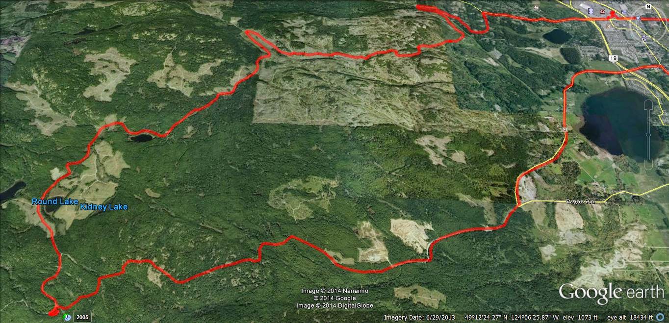
Here's the overview map of this ride: 


The Figure 8 Tour...
1. Doumont Rd stop sign start (near the track where the logging roads begin)
2. Right turn onto Branch 142
3. Left turn onto 155 Main
4. Left turn onto 155 N
5. Crashed water bomber site
6. Left turn onto "Baker Street Connector"
7. Left turn to bridge, Nanaimo River Road and Branch M
8. Left turn onto Branch K
9. "Bridge-Out Workaround" and Shaw Main
10. Left on North Shore Road to Youbou
11. Great eats and coffee at Cassy's Coffee House
12. Right onto Nitinat River Road
13. North along the "Blacktop Highway"
14. Right turn up "The Pass" towards Fourth Lake
15. Along Nanaimo River Road to closed Second Lake Gate
16. Right on Branch C, past gold mine turnoff to "Hellavator" connector
17. "Hellavator" connector leads to "Escalator" connector (shock, horror... read all about it)
18. Right turn on power line trail
19. Right at Branch 142 back to "tank traps"
20. Beer and grub at Black Bear Pub..... AaaaaaHHH!!!


Paul has had this ride idea hatched for a few years now.  He went out riding with Ryan, another riding partner of ours, some years back when they were kiboshed by an ugly "bridge out" section along one route to Youbou.  Paul was on his larger 650 at the time and they decided to avoid a rooty uphill work-around and went off in search of an alternative route which was never found.  The thought of this unfinished route to Youbou festered in the back of his tiny mind and created the twisted riding partner I know today!  But now, likely under the advice of his psychoanalyst, we attempted the route once again in order to cure his rapidly declining mental health.

We started out at our common Doumont Rd. starting place and made our way through the tank traps to Branch 42 where we headed NW to 155 Main.  A left turn onto 155N had us heading directly to a water bomber crash site commonly referred to as the "water bomber near Mt. Moriarty."  (49°10'60.00"N   124°22'60.00"W)  We found the site:  All that remains are a few snapped off large trunks of trees and a circle of trees marked in blue loggers' code to keep them untouched.  No wreckage was visible at all and it can only be assumed that the site was cleaned up when a nearby, (now disused), logging road was installed in the area.

A Old Logging Road Leads Towards the Water Bomber Crash Site

The Water Bomber Crash Location Along a Disused and Overgrown Logging Road
One of Several Trees in this Area Marked for Site Preservation


Onward we plodded to a section of trail which leads to the Moriarty Lake region, aptly named "Baker Steet."  This is a fun section of trail with a few good challenges to keep any rider awake and on their toes.  No wipe-outs through here this time around, but we both managed to get caught up for a minute or two in one particular muddy section.

We continued along branch G. and after taking a wrong left turn, (which you might want to look out for if you use our track), we corrected the route and connected with Nanaimo River Road and a left turn onto Branch K.  This road takes you to the dastardly "bridge-out" location.

Paul was cleverly silent about the nature of this "bridge-out" and its work-around.  I was aware that a work-around existed, but was never really filled in as to how gnarly this section really is.  For some, I'm sure it's a simple matter of twisting wrists with careful clutching in order to gracefully dance their way up the 25° gradient.  I'm not the most competent of riders to begin with, but my newly repaired collar bone had me thinking twice about going up through this patch at all.  Paul convinced me that a good push behind my underpowered Kawi would be all that was needed to get through and he was right, although I dare say I wouldn't have tried this chunk of trail had I been alone.  Poor bastard had to push like hell! :)  We both agreed that going down this rooty slope would be moderately easy.

Paul Clears the River and Begins the Rooty Section

We were faced with a couple of small river crossings after this, one of which was quite boggy with plenty of nasty quadders logs.  Thanks guys, you had me off my bike after glancing off of one of your poxy wood chunks!  I had my left hand nicely trapped under my bars long enough for Paul to snap a pleasing "buddy down" shot.  Go ahead and post that sucker Paul!  You know you wanna!! (Oh, I have, Lemming Boy - it's on the vid!)


Wet Boggy Section's Quadder Crap Beckons Front Wheel
Looking up the Shaw Valley North.  Very inviting: must explore that soon.

From here we continued along the Shaw Main towards North Shore Rd., which took us directly into Youbou.  Halfway along the north shore of the lake, a massive Roosevelt Elk bull crossed right in front of us, herding his 4 largish cows across the road.  It was a close one! (Shots on the vid). We gassed up at a Youbou gas station, (which sells regular, but only marked premium gas), and went on to Cassy's Coffee Shop which is a newly opened venue selling small meals and good coffee.  Drop in there if you're in the area, they are very friendly and the food is good.  Paul is convinced his heated jacket kept him warm on the return trip, but I know it was Cassy's chili working its magic.

Cassy's Coffee House


Fuelling Up Chilli Powered Heating System

After devouring Cassy's tasty nosh, we took off traveling west towards Nitinat River Rd. where a right turn leads you north up the "black top highway" which eventually takes you to Fourth Lake.

The pass leading up to Fourth Lake is superb fun!  We both remembered this road being pretty chunky with quite a few boulders at one time.  It's pretty smooth now and we charged up this excellent steep road at a good pace.  The twisty road and higher side mountains really add to the  overall beauty of this pass.  From here we blasted down Nanaimo River Road hoping to catch the gate open.  It was locked!  I think we both knew it would be, but it was worth a try anyway.

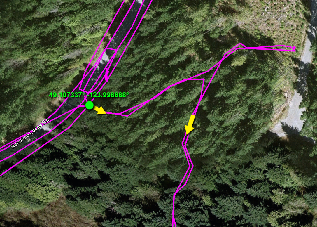
It turns out that the locked gate was a real boon!  We decided to return west along Nanaimo River Road and head up Branch C to the familiar "HeLLeVaToR" connector trail that joins our more local logging roads with the Mount DeCosmos area.  We reached the Hellevator and searched briefly for a trail we have heard about that runs parallel to this trail but is much easier and faster to ride.  After deciding it might not even really exist at all we started down the usual route only to find the elusive connector trail directly ahead of us.  (A big thank you to "The Highway Men" who opened this new connecting trail up.  It's fantastic).  In "REAL Motorcycle Diaries" style it was quickly named "The Escalator" and down we went towards the main floor and ladies undergarments.

The Escalator Starts a Short Distance In


The Newly Visible Escalator Entrance.  Bear left for the gentle escalator ride down; fork right for the Hellevator ride to hell.


After our float down the pillowy-soft escalator ride provided to us by The Highway Men, we followed our standard route out, taking a right-hand turn down through the power lines, zipped past Boomerang Lake and finally through the Tank Traps.  Our final destination, oddly enough, was the Black Bear Pub where we once again administered muscle relaxing fluids (orally of course). 

Elevation Track


Monday, October 06, 2014

155 Through to Moriarty: Baker Street

"Baker Street" is a way into Moriarty Lake from 155
Andy and I found a trail into Moriarty Lake from 155.  "Baker Street"  is perfectly doable for a bike in drier weather, and much more palatable, IMHO, than the old key trail.  The blocked access to 155-160 is for reference.  To get to Nanaimo Lakes Main, turn left (east) at "Moriarty's Key". ATVers that we met later told us the access route to it (green trail below) is easy.  More maps and a video below.

While it looks overgrown on GE, it is not.  The single track quad trail is clearly defined and obviously well used.
The unexplored green trail is accessed easily from 155-160.  
The video is not very exciting, but does let you take a gander at the trail surface and terrain.  It goes from "Sherlock's Trick" to "Moriarty's Key" From there, 4th Lake, "The Great Divide", Nitinat Main etc. are all accessible.  Vancouver Island's backroads are your oyster...Again, apologies for the music...but it fits...;)   [Apology NOT accepted ~Andy]


Google Earth flyover from 155 to the lake shore.   (This is the track of the connector trail that can be downloaded right below this movie.  Use it with the track "Doumont to Moriarty Lake" to find 155).

Here's a track of the connector trail which is a left turn off of 155N when heading SW, (the "unexplored green trail" shown in the photo above).  The track shows the route to the lake shore, bypassing the nasty road block encountered when approaching the lake using just the major logging route.

Couldn't resist a shot of the beast.  Handsome Devil, aint she!


Monday, September 15, 2014

Northwest Bay to Moriarty Lake and Beyond... (New Trail)

A few readers of both Dr. Siouxsie and this blog may remember the Key Trail which we found and rode for couple of seasons.  It was a way into the Nanaimo Lakes Road territory from the Northwest Bay Logging division without having to use the traditional (gated) route via 2nd Lake.  But it was long, rough going at times, and the actual "Key Trail" and subsequent route down towards Third Lake was choked with alder whippers.  We gave up on that trail and have looked for various ways though since. Yesterday, I found one...sort of...

Above (click to enlarge) The red trail is yesterday's ride.  The green trail is the old "Key" trail, so called because it was better than a key to the second lake gate...
Above: Turn left at 155-160, which is signed off 155 a few km past the hydrolines...keep on that extremely well groomed trail, and follow it to the end.  The views and ride are stunning. The connector waypoint at the bottom leads right to Moriarty Lake and the trails beyond...all the way to Nanaimo Lakes road near Third Lake.  It is blocked with 4 or 5 large logs, but where there is a will there is a way...
GPX File can be downloaded here.  Apologes for the quality of the return track.  The GPS seemed to lose it's position and jump around.  The waypoint is a little off, but just ride down 155 and you will see the sign post on the left "155-160".  Take it.  A DR, KLR or Vstrom could make this ride easily, it's wide well surfaced and well graded.  A caution - they are working on this trail, and towards the end you will see the equipment, and the blasting caps.  Weekends only.

Pics and Vids: I was pressed for time, so sorry for the lack of stills, particularly of the Moriarty trail...I'll be back soon and will flesh out this entry...

Alternative Tank Traps...
A tree has been felled in an alleged attempt to block access, again.  There were some rocks.  Rolling over was easy.  Shoddy workmanship by Tim Berwest again.
Marshall Creek Bridge has been dismantled...
Above and Below...Rode over this a couple of years ago.  Plenty of strength left then...

See original bridge here...
 Marshall Lake:
Above: Marshall Lake: the water is very low right now, super clear and the fish were jumping everywhere while I was there.  The trail up is in good repair and easily accessible by bike.
Below: 155-197 Spur.  A steep but easy and rewarding ascent - you really climb!  Views are stunning (iPhone doesn't do it justice...)
155-197 Spur - the end of the line.  This is what looks like the cribbing that I point up at from the Marshall route further south in the video below.
Time lapse you tube video of the ride...Click settings and choose 1080 HD


Google Earth Flyover of this track:


[Andy's Edit:  21/09/2014]

Really felt like I was missing out here, and so I did this route to Moriarty Lake yesterday to try out the new logging road that Paul mentioned.  Fantastic ride... "The Moriarty Highway."  No point in repeating this route with a new blog entry, so...

It's been about a month since I had a good ride.  An old back injury revisited me after hiking up DeCosmos on our last ride together.  I've been keeping off my feet as much as I can since then, but after picking up some decent pain medication that prevents me from emptying multiple bottles of the off-the-shelf stuff and having waiting for my back to recover considerably, I'm ready for a ride once again.  No Paul about!  Off sailing...  How la-di-dah!  (I can see the cucumber sandwiches with their crusts cut off).  Then I guess it's a solo ride.


Beautiful views along the serpentine "Moriarty Highway"

Approaching the lake from the upper road

Moriarty Lake from the road blockage.  (The road block is the pile of logs on the far left) 

The road block prevents you from riding down to the lake, although it's walkable.  
From what I can see, this blockage scuttles any chances of getting through to the roads that lead into the Nanaimo Lakes area.  I guess we have to start looking!

Mama black bear and her cubs.  Saw these guys on the return trip about 5 or 6km from the lake.  I was sure I had seen three cubs, but I guess not.

My track from Doumont to Moriarty Lake.

Made a quick visit to Rhododendron Lake and checked out the progress of the roads that appeared as if they're traveling towards Okay Mountain valley.  They don't connect yet, although there's now a cool trail that climbs a dead-end spur with good views of Okay Mt.  I took our usual route through the valley, back to the power lines, past Boomerang Lake and eventually Doumont using the original tank traps route.

Red shows track available from link directly above, (Doumont Rd to Moriarty Lake), and blue shows my return route.  The elevation profile shows the red track only, with the red arrow locating the highest point at 1023m (3356ft).  
Doumont Rd to Moriarty Lake:  Colour Coded Elevation Track


Here's the whole ride from Doumont Rd to Moriarty lake in time-lapse at 4x speed:


And, the tank traps through the original route at 3x speed.


Saturday, September 06, 2014

Time Lapse Vid of Doumont to Bonnell Main New Route

Ok, it took me a nearly a week to produce this video as the much vaunted free software I raved about last week (GoPro Studio) has developed a bug.  I lost the entire 3 hour production two days ago as it crashed.  Since then, and while re doing the video, it crashed every ten minutes.  I have re-installed, rebooted without success. Like me old step dad said, "you get what you pay for"...Don't forget to turn the settings up to HD.  If you don't like the music, no complaints...just mute it :)

The video references points on the map below:

The ten minute epic...

Saturday, August 16, 2014

Go Pro Studio...Take One & Two

Usual loop, nothing new.  Phantom Road to Doumont Road via Kidney Lake...

Impressed as I am by Andy's time lapse video's via iPod App, I decided to produce a time-lapse video by stitching regular video (MP4) together and then speeding it up...  I am using a Coleman Conquest helmet cam which has the option of shooting in MP4 in HD 1080P @ 30fps and shooting continuously while saving files in 1 minute segments which fit together seamlessly when played back (it's called car mode). The advantage of this is that the files can be uploaded or edited quickly if you wish to cherry pick segments from them rather than sorting through one huge file (which you can do if you are glutton for punishment).  

So I downloaded Freemake Video and stitched 38 one minute MP4 files together, but stupidly checked the "transition" setting so they fade into each other.  I then further complicated things by downloading Go Pro Studio (Free & no malware) to take that single file and speed it up to 6 times speed.  So in all this file was converted from MP4, to as GSV file (a go pro tag), an AVI and then back to an MP4...  This may have impacted quality, so, for my second attempt, I did the same project again in Go Pro Studio only, to see if the quality is improved with as few conversions as possible.  

In Go Pro Studio you can select how many times you want to speed the video up from double speed to hundreds of times...I chose 6.  So I'm not sure how a 38 minute video was shrunk to 5m30...that's more like 7 or more times...  But it's free, and as me old (Step) dad used to say, "You get what you pay for..."

Attempt Two: Ok this was fun.  Go Pro Studio allows you to incorporate slow motion into the vid, controlling it via percentage (100% being normal speed), so I have incorporated a couple of sections of 50% and one of 25%.  Given this is a free program, I am very impressed with the flexibility and quality of the resulting product.  The downside is that it does take a long time to process the video - my 38 minute video compressed to a 7 minute video in about half an hour... 

To improve the quality, maximize the video, click settings and choose HD. Pretty darn good!  Oh, and there's a secret message at the end, but don't tell Andy.  Oh, and apologies for the music, but it is better than Andy's :)...Again - it was free...


The track for this ride can be found HERE.

[Edit, Aug 21st, Andy]
For a comparison, here's the same ride filmed in time lapse at 4x speed using an iPod and the app "TimeLapse."  The last minute is unedited.  Sorry--yes, too lazy to edit it properly. 


Wednesday, July 18, 2012

Looking for the Old Beban Coal Mine


I took a short ride to find the old Beban Coal Mine today.  I entered at Doumont Trail, rode Blackjack Ridge's lower valley to Nanaimo River Road and made my way on blacktop up to South Forks and Nanaimo Lakes Road to find the entry gate shown at the top of the light blue line.

Dark blue - Logging Road that Runs the length of Mt Benson (SE, rear side).  Light Blue - Intended route entering from Nanaimo Lakes Road.  Pink - My GPS track 


The gate was very well blocked with large rocks and so I made my way SE, looking for a way in.  I eventually found a narrow gap between two rocks at 49.107337° -123.998888° and continued south to the mine site.


My entry point into the trails


The mine site - letters correspond to the photos below:
 
a.  I'm not sure what this is, although it looks like nothing more that a shelving unit, (feet on left side).  It's in very good condition and looks to be a little too new to be a mine site artifact, although there is little other reason for it to be there.    Probably Beban's personal Scotch whisky stash.  None left!  :(
b.  Threaded rods protruding from a building foundation

c.  Difficult to see here with the thick undergrowth all around.  This is a deep vertical shaft.  It's marked off with a scrawny bit of lumberman's tape
d.  Deep Shaft
e.  Same deep shaft.  Very loose ground and a very deep hole, so this is the best I can do I'm afraid.  :)
f.  This is the same shaft, but I backed up to see the marking tapes.
g.  Chunk o' anthracite coal.  Lots of this stuff kicking around
h.  Remnants of some old piece of equipment
i.  The obligatory junked car photo. 
j.  Tailings pile
 k.  (no photo)  Another shaft... filled.

It struck me after I had left the site that the original "Beban Mine" waypoint that I lifted from Wikipedia, (seen on the photo with all those yellow letters above), is likely the location of another shaft.  The Beban Mine was in the news during the sixties when a boy had ventured into the mine and was unable to get out.  He died in the mine.  This mine, as I understand it, went in off a slope, and I'm guessing that had I searched this Wikipedia waypoint I would have found that shaft.  GOOD... I have a reason to return on another ride!

**BE WARNED:  If you head into this area, keep your eyes fixed on the ground.  There are numerous vertical shafts and all are covered with thick undergrowth during the spring and summer.  It looks like logging crews have marked trees for cutting or leaving, but aside from their tape, little has been done to call attention to the shafts.  In addition, the ground is loose and crumbly near shaft edges.  Be careful!  ;)

Monday, July 16, 2012

Doumont Rd. to Moriarty Lake and Nanaimo River Rd.

FINALLY, we did it!  We managed to punch through to Moriarty Lake and Nanaimo River Road from the north.  We tried this a few weeks ago when there was still snow up in the nose bleed region, (1015m).  This time, the ridge we were climbing to the east of Mount Moriarty was clear all the way, (sweltering hot actually), and we were able to ride right over the top at 1090m (3576ft).

Here's the route in brief:


1.  Started at Doumont Rd. entrance to logging roads
2.  Turned right at the intersection NW of Boomerang Lk. onto Branch 142
3.  Left onto 155 main
4.  Turned left off of 155 towards mountain ridge NE of Moriarty Mountain onto 155N
5.  Passed "snow" waypoint
6.  Turned right onto key trail linking the northern logging roads to the southern roads (thanks Google E).  There's a nasty downhill section full of young alders shortly after this location. 
7.  Right turn to Moriarty Lake
8.  Lunch at the lake shore
9.  Descent towards Nanaimo River Rd. on Branch G
10.  Nearly went to 4th Lake... oops.  (I've been staring at this route for too long).
11.  NO GUARD at the gate on Nanaimo River Rd.  Their schedule is extremely odd!
12.  Turned left to follow the lower Blackjack Ridge route back to Doumont
13.  Doumont Rd.

Plenty of dust out there today.  The logging trucks were working and we had a few of them blast past us doing 9 869 862 km/h, leaving us confused and dazed in a cloud of thick dust.  The bikes were kicking up plenty too, measurable by the layers of dirt up my sinuses.

The ride up the ridge, (a left off of 155 Main), was noticeably different from the last time we came this way:  The dryer weather and some wear from quads and bikes have loosened dirt and rocks making the road surface quite a bit looser than we both remembered it.  It was pretty easy going, only the wheel had a tendency to spin out more times than last.  It's a great climb up there...  I love how Moriarty Mountain opens up on your right as you get higher.  The weather was so good today; it would have been a good day to bring my decent camera.  Hindsight is 20/20...  I was stuck with only my GPS pics again.

We reached the end of the road as planned and explored the "brownish key trail" we have both been spying on Google Earth, (item 6 above).  Part of me thought this was going to be a complete waste of time and I thought we were in for a line of dead branches and stumps that only appeared to be a trail from satellite.  I was delightfully surprised!


A big log marks the entrance on the right, which starts about 120 yds before the end of the road.  This short joiner trail is about 100 yds long.

It was a good quad/bike trail and had obviously been carved into place by riders who were doing exactly what we were doing;  looking for a route to the lakes and Nanaimo River Road.  i.e. Getting access to the Nanaimo Lakes area even when the logging gates are closed.  (Of course, this is completely legitimate, otherwise there would be signs posted to prevent it).

We made it through with little trouble.  Occasional ditches have been strategically placed to make access more difficult than a straight trail, but these ditches are more of a mild nuisance than a trail stopper.  We continued downward through a series of these ditches, perhaps four or five.

After descending a fair way we reached a "T."  From here you can turn right to Moriarty or left to Nanaimo River Road and Fourth Lake.  Time was an issue today and we decided on saving the " check Fourth Lake gate" ride for another time.  (Note, Aug 31/12:  We've discovered there is no gate.  Hahaha). We began to climb once more and than started to descend towards Moriarty Lake.  There are terrific views of Moriarty Lake and a couple of other no-name lakes as you crest the round road leading to the lake.  We stopped at a large "tank trap" at the end of the road and decided to walk the remaining 170yd four iron shot to the lake.  Ahhhh, lunchtime at the lake.

Moriarty's Lake Shore


We rode the circle road once again and arrived back at the "T" intersection.  Continuing straight we rode a steady and quite lengthy descent down to Nanaimo River Road.  From here we continued along the less-than-exciting N. R. Rd. back towards more familiar logging roads and zipped straight through the unguarded open gate.  This annoys me!  They stopped us a week ago when we attempted to ride through here and turned us back with fully loaded bikes, forcing us to ride the #1 highway down to Cowichan Lake.  Today, they decide that it's okay to leave the open gate unattended.  Who's writing their rule book?

A quick left turn took us back onto more familiar roads.  We rode the lower Blackjack Ridge road back past Boomerang Lake and followed the tank traps back to Doumont.

What an outstanding ride today!  Finally, we conquered Moriarty Lake and we found a way through to Nanaimo River Road and beyond.  :)  It might be a bit of a struggle going the other way, although it looks quite do-able.  We'll see. 

Quad riders:  We need you guys to ride between location 6 and 7 to help stop those alders coming through the road!  :)