Took a quick ride out to the Lantzville foothills to see if the end of John's track was a cabin. It was! It's a bit of a fixer upper, but would give you shelter if you really needed it. I entered the logging roads from the Weigles Rd/Doumont/Biggs side and continued through the new arrangement in the tank traps area using Tim berwests new logging spur. I'm liking it--no muss, no fuss. Track is available at Wikiloc. (Thanks again John).
Here are a few pics:
Panoramic of Immediate Area
Front of Cabin
Left Side (with retired stoves and ice boxes)
l'arriere
Front Looking Towards Exit Trail
Mountain Biking Trails
Building Dedication/Memorial
At the front door looking straight towards staircase
It's a well known fact that if you buy a new motorbike it will rain for weeks. Finally, we've had two rain free days lately and I was able to get the new Beta Xtrainer out for a blast on both days. I met Ryan and Eric at the Wastelands track yesterday for a half day of log jumping and general blasting around, and today I went for a solo ride to find the Eagle's Nest Cabin off Bonnell Main logging road. Big "thank you" to John N. for pointing this location out to me last month.
John had suggested that I try the route in from the top, (walking in from the N.E.), and so this is what I did. Here's my route map:
Click to Enlarge
1. Entered at Harwood Drive. What a hilarious mess they have made of the usual way in. The place is looking like The Maginot Line with its newly dug deep trenches. I thought I was completely hooped until I rode down to the yellow gate at the very end of Harwood to find the walk-in entrance has been widened enough to get a Gold Wing through. I guess they're fighting trucks only these days.
2. The road in has been graded heavily once again. The hilly section has a wide variety of rock sizes from large boulders to scree. Fun ride up, although a little creepy on my new bike which is still a little too high for my stunted Welsh/Scottish legs.
3. Leaving the Lanzville trails, I took a right turn onto Bonnell Main.
4. Keep left and leave Bonnell Main and stay left at the next intersection nearly 200m ahead.
5. You can go either way here. A right turn will lead up a rocky road which eventually reaches a Y intersection. A small quad trail begins between the branches of the Y and this will take you up to the back of the cabin. It's the standard way in, although as John had mentioned to me, the road is quite rocky and the quad trail is steep and rooty. It's quite do-able, and is likely the better way in, even if you're faced with walking. A left turn will take you to a dead-end spur road (6) where you begin a 600m uphill hike to the cabin. (A waypoint for the cabin and this track is available at Wikiloc).
UPDATE (Paul): I dragged Andy back to the cabin on April 2nd via the quad route above (Small Quad Trail). I rode up the small quad trail which was much easier than it looked. What was interesting was after visiting the cabin, and starting to ride back down this route, we saw a truck coming up from the south...
UPDATED AGAIN (Paul). Wednesday, Ap 6th: Tried the "Unknown Large Truck Route" that heads southeast. I approached it from the South, about a km after Kidney Lake. Initially it was easy, but soon got into some large river rock like boulders that you would find in a creek bed. The reason became obvious shortly after that. I turned a corner and the road became a serious hill climb with river rock and wet rock outcrops which make traction very hard to acquire. I tried to surmount the hill 4 times, and each time got stopped at a wet rocky outcrop. It will be doable when dry, but still a challenge. Good fun though.You can see the route in purple on Andy's updated map below.
UPDATED AGAIN (Andy): John N. very kindly sent me this track that spells out the route coming in from the SE side. I believe this is the route he meant when he originally told me to approach from the top side. The trail begins about 1.2 km north of Round Lake. Another possible cabin appears on the screen capture below. Good for an upcoming ride! (found it-click me).
6. Park the bike here and proceed S.W. on foot. Not a great hike and not the preferred route! Directly ahead of you are a couple of marsh areas which are easy to get around if you don't mind clambering over a couple of hundred metres of downed trees.
7. From here there are a number of animal trails that make the going a
little easier until they peter out and you're left with an uphill slog
through more rough terrain. As you continue upward, you'll see a rocky
outcrop covered in moss--the cabin is perched on the flat top, (although
it won't be visible yet). Riding boots are a poor choice to attempt
climbing this rock and more suitable walking/climbing boots would be
worth the carry in. You won't have much of a climb if you navigate
carefully through the trees.
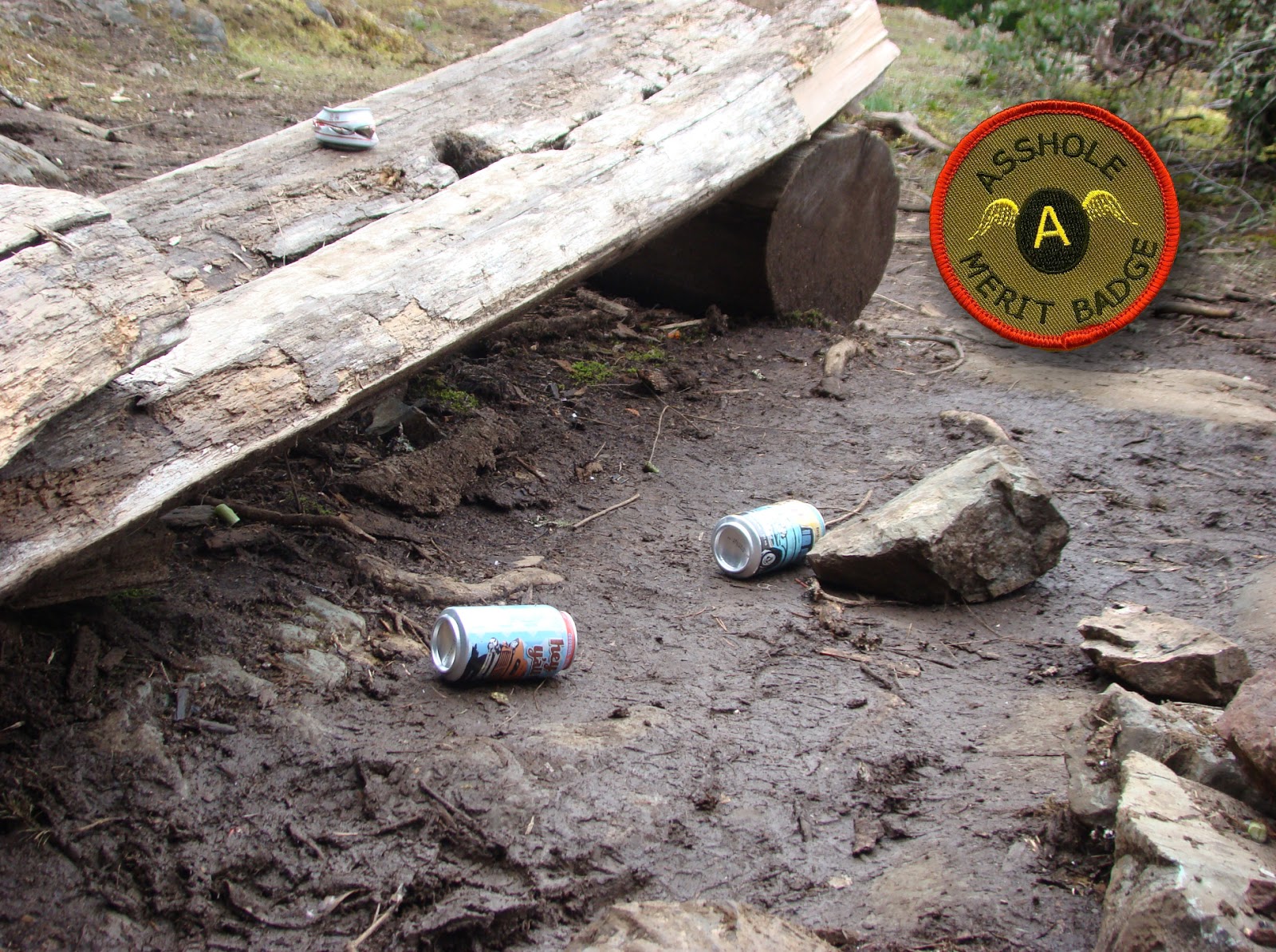
8. After a final short climb up a heavily moss covered rock, you reach the front side of the Eagle's Nest cabin. It's a small (perhaps 10' x 15') cabin with a framed plywood floor and upright log poles to support metal siding material. It's nothing fancy, but it's well enough constructed to keep a few people warm for the night. There's a small wood burning stove inside and water is supplied by a small rain-filled tank. (Advisable to use water purifier pills since I doubt anyone gets up there to shock the tank with chlorine). Bring in some ice if you want to use one of their ice coolers. It looks like people really respect this place, at least the last visitors did. It was clean, tidy and well organized. A guest book is on the table. There's an outhouse and a covered area for dry wood. Four wooden lawn chairs surround the fire pit. Some a-hole left beer cans scattered about the fire pit. Please carry out your crap if you decide to use this open invitation cabin!
9. Having never tried the other way in, I walked down the quad trail for a distance to see what it's like. Quite doable in dry conditions, although rooty and fairly steep in some sections. (Didn't walk it all).
10. After hiking back down the way I had come in, I took a quick ride along the alternative route. I stopped where the road began to steepen and get rocky. Still do-able at this point, but I wasn't ready to start bouncing around too much with this being a solo ride. I turned around since I'd seen the cabin already. :)
11. Rode back along Bonnell Main and passed the entrance back into the Lantzville foothills with a plan to exit the logging roads via the "tank traps."
12. Holy road changes. A new road punched in near the tank traps made this intersection completely unrecognizable. I thought I might need a left turn because I was getting close to the traps, but took a right to see where it went. The road became familiar very quickly and was clearly the route towards Boomerang Lake. I turned back.
13. Took the left turn (location 12) option and rode along a new logging road. This is the road that is now visible from the tank traps when approaching from the Doumont side. I continued along here until the road stopped and turned around to try what appeared to be an obvious route towards the tank traps area.
14. It was just what I wanted and soon opened up into the trail we have been
calling the "Tank Traps Alternative." The trail joins, (as it did
before), the familiar route up through a round-rock riverbed towards
Weigles Rd. and Doumont/Biggs.
15. That's all I have for today. It was an excellent solo ride on my new Beta Cross Trainer!
Video of the ride down from the cabin using the quad track to the "T Junction". (Make sure you turn the Res up to 1080p and watch it on YouTube for better quality.)
Elevation Track
Google Earth Flyover of the Route
The End of the Road: Hike Begins S.W. Towards the Cabin
First View of the Cabin When Approaching from the top N.E. Side
Front and Side of Cabin. Two Windows on the Right Side
Panoramic View: Fantastic View of Nanoose Bay from Up Here!
Christmas ALL YEAR at the Eagle's Nest Cabin
Front Sign
Looking in from the Front Door
Looking Back Towards the Entrance
The Wood Pile and Outhouse
The Back of the Cabin from the Quad Trail Leading Down
I got a chance to take my new Beta Xtrainer out today. Second ride, but this time in the dirt. All I can say is that I'm in love with this beautiful Italian scarlet harlot! I knew there was going to be a marked difference between my trusty old KLX250S and this new flame, but never in a million years did I think the divide between the two would be so great.
Coming from thirty years of riding four-stroke street bikes
and a few years of riding the Kawi dual sport, the two-stroke is a massive
departure for me. Never had a smoker
before! The engine note is going to take some getting used to, especially when I wind her up, but the smooth power delivery took about five seconds to get used to. I'm amazed at the low centre of gravity and lightness, especially when standing. The oil injected 100:1 produces very little smoke off idle; actually I have it running at 50:1 right now with an added 100:1 premix in the tank on top of the injected oil. Dealer wants me to do this for the first two tanks. Smokes like a bastard on start up, but almost completely disappears when at op. temperature.
It was a quick ride today. I took it up to the gravel pit at the end of Doumont Rd. Did some slow turns and balancing practice and tried her on a few hills. Much faster on the bumpy sections than the KLX! Much easier and way nicer to ride standing up than the KLX. I really like my old Kawi, but I'm afraid there's not much competition here. She's definitely going out to pasture. Might end up as my occasional commuter bike. Would make a good super moto for in city riding. Very good little dual sport if you're interested in buying one. ;)
I had the dealer install a few optional extras: Cycra hand guards, pipe guard and the road kit that comes with the bike. Might take the plate holder off and remount the rear signal lights and plate to give me better rear end clearance. I still need to install my GPS holding clamp/ball and power plug-in for trips into the bush. (Beautiful heavily tapered bars on this bike that I really don't want to cover in clamps, but I'm not carrying my GPS around in my pocket).
I had a chance to try a quick ride on the KTM Freeride fairly recently
and found it to be touchy on the throttle control. I think any trails
rider would see the advantage of this snappy acceleration for hopping
the back wheel in an instant burst, but the smoother delivery of power
from the Xtrainer seems to be more useful for the riding we do. Love this bike! Magically turns any crap dirt rider into a mediocre dirt rider. Ah, mediocrity--I have arrived! ;) This year's riding season is off to a great start.
2016 Beta Xtrainer 300 with 21km on the clock!
Get a load of Trevor Campbell, enduro and trials expert, putting the xtrainer through some motions. This will be me in about six weeks. *phffffffbaahahaha*
Ultimately, the best ride on Remembrance Day would have been up to pay our respects at one of the many WW2 era crash sites around here, perhaps visiting the Lockheed Ventura on Mt. Bolduc would have been more appropo. But with the shorter days and our later start, we decided Green Mountain from Doumont Road would be a better plan ~130km round trip.
Click to Enlarge.
1. Doumont Road Tank Traps
2. Left on to 142 and pass Boomerang L.
3. Right at Cottle L.
4. Right and follow Hydro Lines
5. Left after bridge. Left at Hickup Trail
6. Right onto NEW Escalator Trail (Easy). Turn Right as you pop out of the Escalator onto Decosmos/Deadhorse Creek Main (a major logging road).
7. Right at 2nd Lake onto Nanaimo Lakes Road
8. Left onto Branch K (Major Junction)
9. Left onto Green Mountain access road
10. Left
11. Beginning of Green Mountain Meadows and the Marmot Reserve.
Click to enlarge
Elevation Track (m)
Google Earth "Flyover" of the Route (Full Screen to View Text)
It was a great ride, offering a little of everything: some logging roads, technical single track, hill climbs and burms at Green Mountain, not to mention snow. The total distance was approximately 127km from Superstore Gas bar to Green Mountain and back to the Black Bear Pub. I've got to say the rear Mountain Motoz at 10psi was awesome everywhere, particularly up some serious grades in the snow. I didn't air it down to the 4 psi I usually roll on as we were hitting some potentially rim denting speeds on crush, and didn't fancy a pinch flat. Can't wait for a set of Tubliss...
White Trails Near Green Mt. Ski Hill
Maybe the last picture of Andy with the trusty KLX250S. It's been an excellent ride for Andy, but the lack of torque and soft suspension are leaving him looking at Beta 300X Italian Princess. His money is down, and the beast should be here before too long. Can't wait to see it. Anyway, needless to say, we ended up at the Black Bear for a coupla delicious barley sandwiches. What a great way to finish a ride!
Checkout the short vid below for some trail condition samples...(Don't forget to change the settings to 1080P for the best resolution. - First shots with the Go Pro 4 Black. The quality looks much better...Pity about the music!)
Negligible wear on the Motoz Mountain Hybrid after 15 hours of riding mixed road and dirt
If you've been reading, then you know I mounted a MMH rear on the Berg over the summer. It's a hybrid trials/knobby for slower more technical riding. While it's taken a while to get brave enough to run it at the ridiculously low 5-8psi pressures it demands (and is designed for), I have been impressed with the tire. It's got a super-stiff carcass, and while the Pirelli front will often deform at lower pressures, the MMH rear resists impacts well. Off road, aired down, using a judicious throttle and butterflying the clutch, it offers ridiculous amounts of grip in all conditions. Wet, dry, rocky, sandy, stones, logs, roots and mud, it out-performs my previous experience with knobbies. The huge footprint demands your bike has torque to spare, and if it does, then starting from a stop on a steep incline, boulder, wet root or mud-hole it pulls. If it spins, you're using too much throttle, It is still taking me a while to lose the roost habit; this tire does not respond as well as a pure knobby in those circumstances. At speed it also confidence inspiring, but not as "drifty" as a knobby (which can be fun).
If you ride black-top, it gets even better. It's a DOT tire. I ride it to the dirt on the road at about 25psi, Its road manners are good, even aired down. It doesn't "blow chunks" like is reported on true trials tires mounted on dirt bikes no matter what the pressure on the road. After 15 hours it has lost perhaps half a mm of tread: it would be a good DS tire.
If you you enjoy endurocross or just technical trails, then this is the tire for you. I am considering going to the tubeliss system on the bike. The Pirelli Scorp on the front is a great tire, but it is being shown up by the MMH on the rear as the Scorp's carcass is not as robust and doesn't resist impacts as well at lower pressures. The next move may well be a Golden Tire 216 fatty for the front.
It is reported that Motoz are coming out with a lighter version of this tire. Right now I am happy with the present MMH, as I have had no punctures, and great wear, and I don't feel its weight on the bike at all. A lighter MMH may offer something else (I'm not sure what), but may not fair as well resisting pinch-flats at lower pressures or wear as well. We'll see...
The Aussie boys, as usual, have done an awesome review of the MMH tire too. So if you don't believe me, tune in below...
Finally, a blog entry! Our readership of six is probably down to three or four at this rate! Anyhow, it has been a long time since I made a blog entry due to a broken collar bone and long lasting back problems, but we're back with a vengeance to tell you about our recent 250km "Figure 8" ride from Doumont Rd to Youbou and back.
Here's the overview map of this ride:
The Figure 8 Tour...
1. Doumont Rd stop sign start (near the track where the logging roads begin)
2. Right turn onto Branch 142
3. Left turn onto 155 Main
4. Left turn onto 155 N
5. Crashed water bomber site
6. Left turn onto "Baker Street Connector"
7. Left turn to bridge, Nanaimo River Road and Branch M
8. Left turn onto Branch K
9. "Bridge-Out Workaround" and Shaw Main
10. Left on North Shore Road to Youbou
11. Great eats and coffee at Cassy's Coffee House
12. Right onto Nitinat River Road
13. North along the "Blacktop Highway"
14. Right turn up "The Pass" towards Fourth Lake
15. Along Nanaimo River Road to closed Second Lake Gate
16. Right on Branch C, past gold mine turnoff to "Hellavator" connector
17. "Hellavator" connector leads to "Escalator" connector (shock, horror... read all about it)
18. Right turn on power line trail
19. Right at Branch 142 back to "tank traps"
20. Beer and grub at Black Bear Pub..... AaaaaaHHH!!!
Paul has had this ride idea hatched for a few years now. He went out riding with Ryan, another riding partner of ours, some years back when they were kiboshed by an ugly "bridge out" section along one route to Youbou. Paul was on his larger 650 at the time and they decided to avoid a rooty uphill work-around and went off in search of an alternative route which was never found. The thought of this unfinished route to Youbou festered in the back of his tiny mind and created the twisted riding partner I know today! But now, likely under the advice of his psychoanalyst, we attempted the route once again in order to cure his rapidly declining mental health.
We started out at our common Doumont Rd. starting place and made our way through the tank traps to Branch 42 where we headed NW to 155 Main. A left turn onto 155N had us heading directly to a water bomber crash site commonly referred to as the "water bomber near Mt. Moriarty." (49°10'60.00"N 124°22'60.00"W) We found the site: All that remains are a few snapped off large trunks of trees and a circle of trees marked in blue loggers' code to keep them untouched. No wreckage was visible at all and it can only be assumed that the site was cleaned up when a nearby, (now disused), logging road was installed in the area.
A Old Logging Road Leads Towards the Water Bomber Crash Site
The Water Bomber Crash Location Along a Disused and Overgrown Logging Road
One of Several Trees in this Area Marked for Site Preservation
Onward we plodded to a section of trail which leads to the Moriarty Lake region, aptly named "Baker Steet." This is a fun section of trail with a few good challenges to keep any rider awake and on their toes. No wipe-outs through here this time around, but we both managed to get caught up for a minute or two in one particular muddy section.
We continued along branch G. and after taking a wrong left turn, (which you might want to look out for if you use our track), we corrected the route and connected with Nanaimo River Road and a left turn onto Branch K. This road takes you to the dastardly "bridge-out" location.
Paul was cleverly silent about the nature of this "bridge-out" and its work-around. I was aware that a work-around existed, but was never really filled in as to how gnarly this section really is. For some, I'm sure it's a simple matter of twisting wrists with careful clutching in order to gracefully dance their way up the 25° gradient. I'm not the most competent of riders to begin with, but my newly repaired collar bone had me thinking twice about going up through this patch at all. Paul convinced me that a good push behind my underpowered Kawi would be all that was needed to get through and he was right, although I dare say I wouldn't have tried this chunk of trail had I been alone. Poor bastard had to push like hell! :) We both agreed that going down this rooty slope would be moderately easy.
Paul Clears the River and Begins the Rooty Section
We were faced with a couple of small river crossings after this, one of which was quite boggy with plenty of nasty quadders logs. Thanks guys, you had me off my bike after glancing off of one of your poxy wood chunks! I had my left hand nicely trapped under my bars long enough for Paul to snap a pleasing "buddy down" shot. Go ahead and post that sucker Paul! You know you wanna!! (Oh, I have, Lemming Boy - it's on the vid!)
Wet Boggy Section's Quadder Crap Beckons Front Wheel
Looking up the Shaw Valley North. Very inviting: must explore that soon.
From here we continued along the Shaw Main towards North Shore Rd., which took us directly into Youbou. Halfway along the north shore of the lake, a massive Roosevelt Elk bull crossed right in front of us, herding his 4 largish cows across the road. It was a close one! (Shots on the vid). We gassed up at a Youbou gas station, (which sells regular, but only marked premium gas), and went on to Cassy's Coffee Shop which is a newly opened venue selling small meals and good coffee. Drop in there if you're in the area, they are very friendly and the food is good. Paul is convinced his heated jacket kept him warm on the return trip, but I know it was Cassy's chili working its magic.
Cassy's Coffee House
Fuelling Up Chilli Powered Heating System
After devouring Cassy's tasty nosh, we took off traveling west towards Nitinat River Rd. where a right turn leads you north up the "black top highway" which eventually takes you to Fourth Lake.
The pass leading up to Fourth Lake is superb fun! We both remembered this road being pretty chunky with quite a few boulders at one time. It's pretty smooth now and we charged up this excellent steep road at a good pace. The twisty road and higher side mountains really add to the overall beauty of this pass. From here we blasted down Nanaimo River Road hoping to catch the gate open. It was locked! I think we both knew it would be, but it was worth a try anyway.
It turns out that the locked gate was a real boon! We decided to return west along Nanaimo River Road and head up Branch C to the familiar "HeLLeVaToR" connector trail that joins our more local logging roads with the Mount DeCosmos area. We reached the Hellevator and searched briefly for a trail we have heard about that runs parallel to this trail but is much easier and faster to ride. After deciding it might not even really exist at all we started down the usual route only to find the elusive connector trail directly ahead of us. (A big thank you to "The Highway Men" who opened this new connecting trail up. It's fantastic). In "REAL Motorcycle Diaries" style it was quickly named "The Escalator" and down we went towards the main floor and ladies undergarments.
The Escalator Starts a Short Distance In
The Newly Visible Escalator Entrance. Bear left for the gentle escalator ride down; fork right for the Hellevator ride to hell.
After our float down the pillowy-soft escalator ride provided to us by The Highway Men, we followed our standard route out, taking a right-hand turn down through the power lines, zipped past Boomerang Lake and finally through the Tank Traps. Our final destination, oddly enough, was the Black Bear Pub where we once again administered muscle relaxing fluids (orally of course).