Showing posts with label jameson. Show all posts

Sunday, February 05, 2012

Another Cheesy Time-Lapse Movie

I decided to have another go at making a time-lapse movie today.  Galloway Gulch Trail seemed like a perfect choice; it's really local, it's below the snow line and I didn't get an accurate GPS track of it yet.  Here's the routes:

The red route (top to bottom) runs from Galloway Gulch Road to Jameson Rd.  The orange spur goes from the main trail up to a bivouac overlooking the Doumont area.  Surprisingly, both trails matched my earlier guesses of these routes quite accurately.
Here's a YouTube time-lapse video of the ride.  The movie starts at Allsop Rd (off Jingle Pot), runs the length of the Galloway Trail where it turns 180° at the yellow gate before turning left onto the bivouac spur trail.  Sure looks good on the even road surface, but the bouncing on the trails reduces the quality substantially.  The opening title is incorrect:  my iPod battery decided to cut the movie short!  In real time it's only about 40 min, and the total running time is only 2:30.  I can't believe the changes on this trail since the summer; they've logged the crap out of it!

 
Here are a couple of Garmin camera shots too:

The bivouac at the end of the orange trail
From the bivouac, looking out towards the Doumont Road area

Sunday, September 04, 2011

Mapping Galloway Gulch Rd. to Jameson Rd. (& Spur Trails)


I went out today for a short ride and mapped the trail form Galloway Gulch to Jameson Rd.  The previous post contained little detail and I figured if local riders want to try it they need a little more info.  (I can just imagine hoards of bikers heading there now.  Okay, one or maybe two).

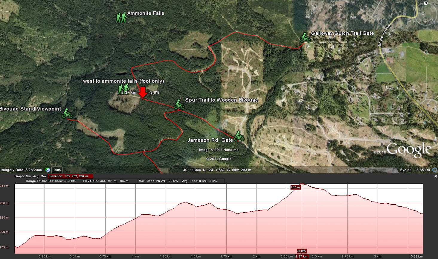
I took my GPS out today and marked waypoints along the trail so I could show a more accurate path on Google Earth.  Google has some really great features:  If you right click a saved path in the lower left pane, it allows you to display an "elevation profile."  I thought I'd post some pictures of the trails with elevations shown today.  These images show up full size when you click them.  The large red arrows on the elevation pictures are showing the high point for that particular trail.

Galloway Gulch Rd. to Jameson Rd. with both Spur Trails Shown

Galloway Gulch Rd. to Jameson Rd. Trail with Elevation Profile
Spur Trail from Main Trail to Wooden Bivouac with Elevation Profile


Spur Trail Off the Bivouac Trail Leading to Big Rock Viewpoint with Elevation Profile

I did solve a small mystery out there.  When I explored these trails with Paul we left one of the spur trails unexplored.  I zipped up it today and stopped at a rapidly narrowing footpath that was clearly going to give me trouble if I went further.  Ahead was a wooden sign attached to a tree:  "This Way to Ammonite Falls."  Paul and I had both walked to the falls before, but neither of us could remember the entrance.  This wasn't the way I went in on foot before, but it's a great way in if you're parked on Jameson.  Must try that!

Spur Trail Leading West Into Ammonite Falls.  (West is left... Those little green people are leaving).   :) 
I've got to find a way to create these recorded paths easier.  I know any Garmin's GPS will handshake well with Google Earth and make the practice of creating paths very easy.  The iphone can do it too with apps like Breadcrumbs, although I think you're faced with entering waypoints into Google manually with that too.  My eXplorist (Megellan) makes it a long process of manually marking waypoints and then manually typing them into Google one by one.  It works, but it's a real pain in the butt.

I think that's it for this trail for now.  There are a few offshoots that look interesting, but there are other places that are calling a bit louder.  I'm needing a fish from Boomerang Lake!  Any lake'll do though....

Saturday, September 03, 2011

Galloway Gulch Trail

What a novice!  I need one of those magnet N things on the back of my bike.


I've been riding around on the new Kawi 250 desperately trying to keep the RPMs lower than 4000.  On the street that keeps up with all the electric bicycles and the odd retiree driving his mobility scooter to the shops.  It's hard to do; not because it's not fast enough, but because I feel like I'm lugging the engine too much.  My trusty Kawasaki shop assures me I can go as high as 6000RPMs when I hit 800Km on the odometer.  Whoopee, I'll pass the mobility scooters. In reality it's not that bad; in sixth gear I can get almost 70Km/h @ 4000RPMs.  I'm going over a tad occasionally, but not much and not very often.

On the dirt it's another matter!  Being a beginner on the trails, I'm having no trouble keeping it well within the limitations set by General Tojo at the Kawasaki shop.

I decided to do an investigation of some local trails not ten minutes up the road.  Nanaimo locals know there are many good trails surrounding our local Mt. Benson and so I set off on Jingle Pot Rd. to look for a trail I had walked a year or two ago with my wife.  I found it at the end of Galloway Gulch Road.  Once into the trail a left turn onto sharper chipped gravel takes you off the walking trail and onto what looks much more like a small old logging road.  I was amazed how quickly it's possible to get out of the city and into what feels like back country.

Two minutes into the trail.  Seeded new growth trees in the distance.

 
A quick movie showing the terrain of the photo above.  

A steeper grade on crushed gravel. (returning)

The trail makes many interesting falls and rises and contains a number of off-shooting spur trails.  I decided to keep to the main trail and see where it came out.  I reemerged on Jameson Road above the Benson Meadows estate.  That was enough for now and I decided to return the way I had come in and end a really terrific ride.

On arriving home, my friend Paul had just emailed me asking if I was up for a ride.  I'm always up for a ride!  I suggested that we return to the trail I had just ridden; perhaps we could investigate some of the spur roads too.

Together, Paul and I repeated my earlier trip from Galloway Gulch to Jameson and then we doubled back to explore a spur road that rose steeply up Mt. Benson.  ("Steeply" to be taken as a relative term since I'm a rank beginner at this, although it was pretty friggin steep).  

It was fantastic.  The trail led to a small bivouac set on the hillside overlooking the Doumont Rd. valley, the wastelands and Brannen Lake.

Mt. Benson bivouac facing Doumont Rd.  (Photo courtesy of Paul's blog.  Bwaaahaha)!
 
A second spur road took us more centrally on the mountain facing Nanaimo.  Paul assures me that the gigantic piles of bear crap are nothing to worry about.  I worry about anything that can crap that big!  (He also assured me later that it didn't come out of his bike as I had wondered).  The road ended at a felled tree that appeared to have been placed by a developer or logging company.  We had climbed to about 2000ft before heading back.

The blocked trail at 2000ft.  (Courtesy Paul)


What a great ride.  I'm hooked.

CLICK ON ME!  (Galloway Gulch Gate, Trail Meets Jameson Rd, Felled Tree Blocks Trail, Big Rock Viewpoint)  See later post for better mapping of this trail.