Thursday, December 22, 2011

Another Look from Beautiful Blackjack Ridge

I went up Blackjack Ridge again today.  I've been wanting to tryout the longer trail that travels along the length of the ridge because it looks like the views would be pretty spectacular from up there.

Here's today's route:

Entered trails from Weigles Road entrance (left to right).  (Click to enlarge).
 

It was really bloody cold out there today.  I met snow near the top of the ridge and chickened out from completing the route as intended, stopping instead to take panoramic photos SW from the ridge.  My original plan had been to go beyond the longer purple line above by about 1.5km.  That would have taken me to the best viewpoint on the ridge.  I really want to check out the rest of the route when the snow melts, although I have a feeling it's going to be white for a while up there.

Snow!!  Pretty nasty in places too.  Perfect for slowing the riding down a tad.  There was just enough gravel here and there to avoid the ice patches.

As high as I got today.  (End of the purple line on route map).
  
SW facing, 180 Panoramic from the ridge (Magenta line on route)
 
Overlooking Blackjack Lake... Facing SW.  (Magenta trail on the route).
 
180 degree panoramic image (low res) made from a video I took.  (Magenta trail on the route).
Same trail
With all this snow around, I had to get a couple of shots of Round Lake frozen over, so I flew over in that direction before the sun got too low.

Round Lake frozen over.  Hard as rock... I bounced several fairly large rocks across it.

Terrific ride!

Saw two large 4x4 trucks coming through the tank traps on the way out.  Very impressive.  How they got those things through there is anyone's guess.

Oops, almost forgot the 3D anaglyph shots for the dorks with the red/cyan glasses!  Here's two:

Looking SW from Blackjack Ridge.  (Needs red/cyan 3D glasses).

Looking SW from Blackjack Ridge.  (Needs red/cyan 3D glasses).

Sunday, December 18, 2011

Two Views from Blackjack Ridge

I took a ride by myself today and went exploring a couple of Blackjack Ridge spurs off the main Blackjack logging road.  Here's the route in from Weigles Road/tank traps:

The Big Picture

Zoomed In on the Route (Right to Left)
It was really boggy through the tank traps today.  Easy riding on the way in, but a bit nasty on the way out with rear wheel spins through the gumbo. 


I turned left onto this small trail off the main Blackjack route.  The early part of this trail gets quite steep, but soon settles down to a very comfortable climb on an excellent small rock chip and sand base.  I stopped to take pictures from both dead-end spurs.


Viewpoint One  (180 Degree Panorama)
Viewpoint Two  (180 Degree Panorama)

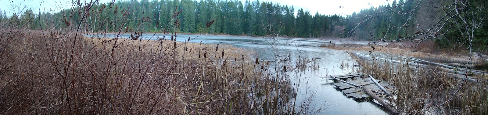
 The ride down is a perfect example of a ride where you DON'T WANT TO TOUCH THE FRONT BRAKE TOO HEAVILY:  Steep with deep sand in places.  There were plenty of ice chunks on the trails today, (real pink fingers weather), so on the way back I took a quick peep at Boomerang Lake to see if it was iced over.  It wasn't iced over, but it was well on its way.  I'll have to come and take a look at it around January.   

Half Frozen Boomerang Lake
 The new fishing dock that some kind soul put in place has almost floated away with the rise of water level in the lakes.

Cottle Lake had even more ice.  The rings are where people have tried breaking the ice with rocks.
Great ride...  Time for a wash!
Now for the 3D Anaglyph image for the dorky people with red/cyan glasses (view full size):