Showing posts with label decosmos. Show all posts

Saturday, September 06, 2014

Time Lapse Vid of Doumont to Bonnell Main New Route

Ok, it took me a nearly a week to produce this video as the much vaunted free software I raved about last week (GoPro Studio) has developed a bug.  I lost the entire 3 hour production two days ago as it crashed.  Since then, and while re doing the video, it crashed every ten minutes.  I have re-installed, rebooted without success. Like me old step dad said, "you get what you pay for"...Don't forget to turn the settings up to HD.  If you don't like the music, no complaints...just mute it :)

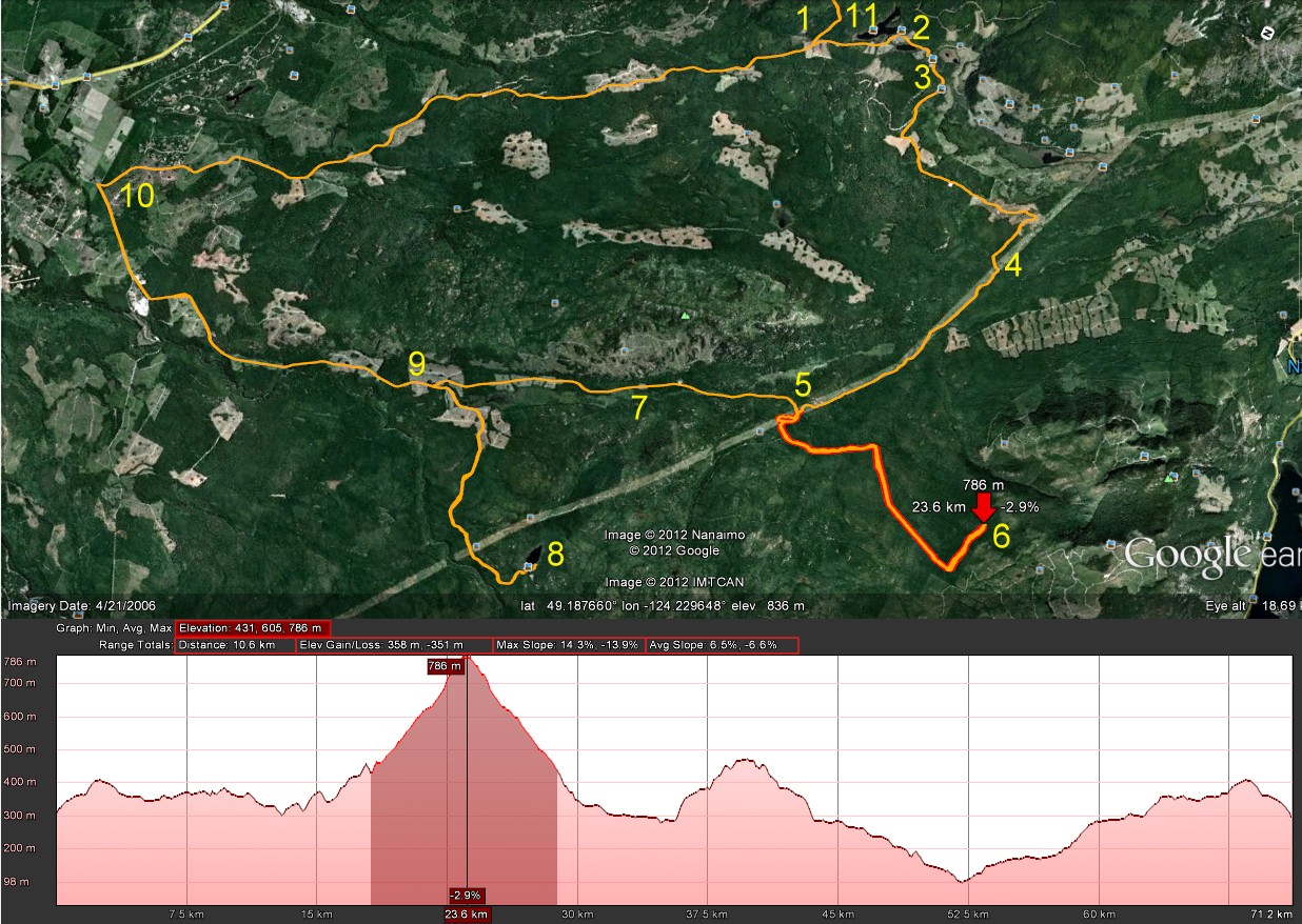
The video references points on the map below:

The ten minute epic...

Tuesday, August 12, 2014

Back to Find Mt. DeCosmos' Summit


Poor quality pano from the top...1st and 2nd Lakes 4000 odd ft below...(Click to enlarge all images)
We were up on the Mt DeCosmos roads around mid-July for the second time when we rode up the second lower summit as far as roads would take us.  Not enough--we've wanted to get right up to the summit and look over the other side at the Nanaimo Lakes for quite some time now.  So, this was today's plan:  Follow much of our July route and hike to the summit.

The route:


1.  Entered the Lantzville Foothills roads through the Harwood Drive Workaround and followed the beaten path to Bonnell Main (Sundew Main)
2.  Left turn to join the main logging roads (Bonnell)
3.  Round Lake and Kidney Lake area
4.  Left onto Branch 142 towards Boomerang Lake
5.  Right turn after Boomerang
6.  Turned right on the "Power Line Trail"
7.  Exit left towards Mt. DeCosmos (see photo directly below for additional details).
8.  Through "ThE HeLLeVaToR" trail... (bwaaaaahahahaha), then turn left on DeCosmos roads.  (Actually, the trail leading towards the "Hellevator" suits the name better.  We've tamed this hell spawn wannabe--little softy satanic trail that it is....pffff).
9.  End of second summit road.  Parked and turned left to hike up the slope to the top.
10.  Not a bad hike.  We had to stop a few times to catch our breath, but it was fairly easy going for the most part.  Bring water! 
11.  Stopped for a while at the transmitter that sits at the summit.
12.  Lots of trees to hike around to find the good viewpoints of the Nanaimo Lakes.  We found a couple of rock outcrops that get past most of the trees.  Photos below ;)
13.  Retraced our steps to the Alternate Tank Traps.  (This route has recently become usable again after two recent dig up sessions by the logging company)  Works for now, but get in quick folks, because when they find out...
14.  From Doumont to the Black Bear Pub to celebrate our victory!

Some additional details for left turn at location #7

Colour Coded Altitude Track:  Range = 103.5 m to 1331.6 m (339.6 ft to 4368.77 ft)  
Google Earth Screen Capture Showing Elevation Profile (Click for Better Detail)


Here's a GoogleEarth flyover video of the route.


Here's a "fly on the map" 100x animation of this track.  I left the GPS sitting a couple of times, so you'll have to be patient with the occasional 100x wait.  ;)


Looking Back Towards Okay Mountain from DeCosmos 2nd Summit

Transmitter

Some guy who was working on the transmitter

Looking SE towards First Lake
Clearer View:  SE Towards First Lake
Looking NE Towards the Winchelsea Island Group 
"Crash Corner" is directly above the "NE" in the above caption...Our first attempt at summiting DeCosmos left me with months of physiotherapy, and Andy with a damaged bike...You can read about that and see the route here...De Cosmos, De Crash and De Lesson...  You cannot get to this peak from the Crash Corner route (without a fair hike), but it's just possible you might be able to hike up to the "other" DeCosmos peak from the end of that road.

The Park 'N' Climb Spot...  Ready to Head Back
Shots of the riding conditions and what you can expect to encounter (surface quality and terrain) referring to numbers from the map:

Above - Between 6 and 7: The hydro-line trail was as usual dry and easy


Between 7 and 8 - Above and below - the trail connecting the hydro lines to the Hellevator can be fast and smooth, but is littered with boulders from winter runoff.  It seems longer every time we ride it!

Between 8 and 9: this gate was open in July.  The workaround is simple - the strange little gatekeeper sliding down the bank from his cave on high - directed us to the workaround (he's standing on it).  As we rode around, he slapped his leg and laughed, explaining that the joke was on us, as the gate wasn't locked!  "What's the point?!" we retorted.  He simply placed his index finger to his temple and replied cryptically that, "Tim Berwest works in mysterious ways."
Close to 9: almost there.  Look at that surface!  Dirt bike Nirvana!
8...Descending the Hellevator...You may be able to click and improve resolution, by clicking the settings button...

Track available HERE.
Fantastic ride!  If you decide to follow our track, make sure you wear a bright orange shirt so you can attract as many wasps as possible while on the summit.  This is particularly important if you want wasps to cluster around your sandwich and water bottle.  ;)

His nibs, replete in luminous orange insect attracting shirt (snicker), directing wasps, horse flies and various other biting insects to "Sit".  It must be the altitude.
EDIT:     Ah, here we are.  The proof:  "I command you to SIT!"

Monday, July 14, 2014

Hellivator Trail to Dead Horse Creek Gold Mine: Finally Got Through

Long time no post!  It's been so long since I updated this blog that I've forgotten how to use this editor.  Under increasingly heavy demands from my readership of at least three people, I've decided it's time to post a few entries again.  I intend on keeping them fairly brief, but will continue to break down routes briefly on numbered maps.

Took a fantastic ride yesterday up to the Mt. Decosmos summit with Paul.  We took the yet untried technical connector trail that joins the powerlines trail to the network of trails in the Nanaimo Lakes area.  Here's the ride in brief:

 
1.  Entered on Phantom Rd.  New blockages attempted by Timberwest only lasted a few days here.  A small gap on the right of the fence will allow bikes in.  Quads are screwed at this gate for a while.
2.  Wrong turn left.  Paul's fault!
3.  Followed beaten trail through the Lanzville Foothills.
4.  Joined main logging roads at the Bonnell Main and proceeded towards Kidney and Round Lakes.
5.  Passed blocked entrance (left) to "tank traps."  Nice MASSIVE fire hazard TimberWest!  What a stupid thing to do!  Ridiculous overkill by cutting down all of the "early succession" trees to block the already blocked trail.  What idiots you are!
6.  Left turn to Boomerang Lk.
7.  Right turn right after Boomerang.
8.  Right turn to follow power line trail.
9.  Left off of the power lines trail to meet with connector trail leading to Nanaimo Lakes area.
10.  "The Hellivator" technical trail joining power lines area to Nanaimo Lakes roads.  This is an essential local trail to know if you want to get out to the Nanaimo Lakes area easily.  (What's the real name folks?  This trail has a fairly well-known name, although "Hellivator" is perfect if your front tire is as worn as mine.  ;)
11.  Mt. Decosmos trails.  It's fantastic up there and I highly recommend taking some time to get up there for the excellent views of Mt. Arrowsmith and Mt. Moriarty etc.
12.  The second summit trail at 1256m.  I want to return and see if the narrow trails appearing on Google's 2005 maps continue towards the summit as they appear to do.  Looks like a good hike.  The views of First and Second Lakes from the top of Decosmos must be fantastic.  Must try this!
Comparing mountain heights to those in Old Blighty, Decosmos is 171m (561ft) higher than Wales' Snowdon and 88m (289ft) smaller than Scotland's Ben Nevis.  
13.  Revisited Deadhorse Creek Gold Mine.  Fantastic spot to look around.  If you go there, bring a decent flashlight.  Right at the end of this trail, you'll need to climb down a small cliff using the ropes attached to trees.  The mine entrance is located off to your right once you climb down. 
14.  Attempted to leave through the Second Lake yellow gate.  Locked of course... Wouldn't want people to enjoy the local lakes.  Turned around.
15.  Retraced a direct route to the tank traps work around.  This route connects you half way along the older tank traps route that was recently blocked by TimberWest.  It's slightly more technical than the old traps, but pretty easy to get through.
16.  Black Bear Pub for copious amounts of cold beer.  Highly recommended!

The route shown with colour coded elevation.
The summit, (pink on previous shot), showing trail on 2005 Google Earth map that continues from where we stopped.  Must go back and find this. 
Google Earth flyover of the route


100x animated view of this ride.  Best viewed if you click on the YouTube icon below the video once it's running and then up the settings to 720p and full screen.  Includes a few stops and walkabouts, so if you're not interested in looking at the track in further detail this is a total yawn fest. :) 


Panoramic view towards Mt Arrowsmith and Mt Moriarty


Walking the "Hellivator" before taking the bikes up

Beginning section up the creek bed

A few roots to navigate

The top - Mt. DeCosmos trail network

Looking out towards Mt. Moriarty

Fantastic views - Worth the ride just for that

Slope and short cliff climb down to the mine


Mine entrance

Creek along side the mine entrance


Wikilocs track of this ride is available here.

Further reference to the Deadhorse Creek Gold Mine on this Oct, 2012 post

Great photos and a video of "The Hellivator" trail from Paul who accompanied me on this ride can be seen on his blog.  Click HERE!  (Be warned:  This blog sometimes contains dainty photos of blossoms and even butterflies... phffff).

Monday, October 08, 2012

Deadhorse Creek Gold Mine

Holy cow... No blog updates for a while now!  This one was such a great ride it must be recorded.  Paul and I have been waiting to do this ride for quite some time.  I found reference to a gold mine for sale in the Mt. DeCosmos area towards the end of the riding season last year.  Now that we have found a tried and true route into the Nanaimo Lakes region without having to use a gate, we decided the time was finally right to go and find this mine.  Actually we attempted to get there a week earlier following trails along the north side of Decosmos from the power lines, but the trail didn't look too friendly.  We walked it and managed to reach the DeCosmos road and we quite likely could have got the bikes through the rocky trail, but we just didn't welcome the struggle.  So, on Sept 29th we made our way through the standard Moriarty Lake route using what we have come to call "the key trail."

Here's our route to #19 (the mine) and back to the starting point at Doumont Rd:


 1.  Stopped and watched some amazing young riders flying over the track at the Nanaimo Motocross Assoc. (Wastelands).  Very skillful riders on that track.  We met up with Ryan there, who was able to join us on his 450 KTM.  VERY nice bike!
2.  Through the tank traps.
3.  Left turn on Branch 142 towards Boomerang Lake.
4.  Past Boomerang Lake, turned right and then right again towards the power lines route.
5.  Headed NW along the power lines.
6.  Right turn to follow Okay Mountain Valley, (on west side of mountain).
7.  Left onto 155 main.  Got to try Ryan's KTM here... WOW!
8.  Turned left off of 155 towards mountain ridge NE of Moriarty Mountain onto 155N.
9.  Left turn towards mountain ridge.
10.  Ridge Trail NE of Mt. Moriarty
11.  Turned right onto "key trail" linking the northern logging roads to the southern roads (thanks Google E).  There's a nasty downhill section full of young alders shortly after this location.  (Might not be easily accessible if quaders don't hurry up and help us in keeping the trail usable).
12.  Down through alders.
13.  Left turn towards Healy Lake.  This was a failed attempt to get through to the DeCosmos roads by cutting past Healy Lk. 
14.  We stopped briefly at the lake to take a look:  Catch and release with non-barbed hooks here.  Daily limit=0. 
15.  Past the lake it began to get pretty steep and rocky.  Too rich for my blood!  Ryan had little trouble blasting through this section on his KTM, but Paul and I would have had much greater difficulty.  Do-able I think, but not without pushing and pulling each other.  :(  Much easier to continue through Nanaimo River Road.
16.  Back onto the main trail and downhill to Nanaimo River Road.
17.  Left turn at the beginning of Second Lake to follow the road leading up Mt. DeCosmos.
18.  Right turn onto mine trail and a sharp left again up a well grown in trail that begins to climb a bit steeper.

19.  We reached the Deadhorse Creek Gold Mine.  The narrow trail comes to an abrupt end where it meets the creek.  You can see the mine opening from here if you look slightly upwards at about 2 o'clock.  You need to climb down into the creek bed, which is about 15ft below you.  Someone has very kindly attached a couple of ropes to a tree to help you climb down about ten feet.  Once down, the entrance is clearly visible to your right and easy to reach.  (It has a flat roof, which I found a bit surprising).  We entered the mine for about 50m and encountered a vertical ventilation shaft that lets a good deal of light in.  From here there are a couple of spurs leading off in different directions.

We discovered that Paul had acquired a large metal staple in his rear tire.  It was pretty clear that a gentle ride out would be the best fix.  Excellent bit of riding on his part, not only in protecting the rim from damage, but staying upright on a tire with broken beads down a pretty bumpy trail.

20.  Luckily, the yellow gate was opened by a truck ahead of us and we escaped through without needing to retrace our route heading north.  We turned left shortly after the main gate and continued towards Doumont on logging roads once more.
21.  Continued along the SW side of Blackjack Ridge.
22.  Right towards Boomerang Lake.
23.  Thru the Tank Traps and out to Doumont to put Paul's sick bike onto Ryan's truck.  ;)

Here's some photos:

Healy Lake

Parked at Healy Lake
 
The end of the trail leading up to Deadhorse Creek.  You gotta wonder how that staple managed to get up there.  Surely nobody would be stupid enough to keep riders away from looking at a mine by puncturing their tires? 
 
Climbing down into the creek bed

Climbing down using the ropes.  You can see the entrance to the mine in this shot:  Look at the tree on the right.  Now look between the two sets of main branches on the left side of this tree.  The darker spot in the gap between is the mine opening.

You can see the mine entrance a little clearer here.  Ryan is pointing his camera directly at it.  I'm standing at the bottom of the ropes where we climbed down.


The mine entrance, (lit by daylight).  Square!?  I thought rounded would have been stronger/safer.  What do I know?
    
In the mine.  Looking back towards the entrance.

Looking up.  This is a vertical shaft about 50m into the mine.  Pretty wet here...  Lots of water dripping into the mine from this spot.  There were a couple of rotting timbers that appeared to be carrying some load at this location.  Good time to watch your step a bit more carefully.  Tons of ventilation happening... No worries about gasses, although I guess that's more of a coal mine problem.

Oh, another shot of the entrance, like it's any different when you're on the way out.

Ryan at the entrance and Paul further back making ridiculous "scary faces" with his little Walmart flashlight.

Detail view of the road past Healy Lk. where we turned back.

Detail view of the DeCosmos road that begins left, right before Second Lake.  The top shows the right turn onto the mine road and the following left turn up towards the mine.
Outstanding ride!  Highly recommended!

(Updated route to this mine with a downloadable track can be found here).

Thursday, June 21, 2012

Another Try Towards Mt. DeCosmos

I decided to have another try at getting to Nanaimo Lakes Road using the "roads" (pfffhgh) leading towards Mt. Decosmos, (from the north).  I tried attacking Nanaimo Lakes Road from trails to the east of today's route a few weeks ago, and I noticed there was another possible way in just up the power lines route that needed to be tried.  Here's the route:


1.  Entered via Doumont Trail
2.  Turned right south of Boomerang Lake
3.  Right at next intersection towards the power lines route
4.  Onto the power lines route heading west
5.  Trail leading towards Decosmos Mountain
6.  The climb...  Very old and overgrown trail...  Turned back at ~790m
7.  Okay Mt Valley towards Rhododendron Lake
8.  Rhododendron Lake to take pics of rhodos!
9.  Rain!  alt route back towards 142 main
10.  142 main back to Doumont and civilization

The plan was to follow this pink route:


Left...  Beginning the "Decosmos" trail.
 
It was a tall order and I really didn't expect to make it all the way, but I wanted to see what it looked like out there.  The trail wasn't that bad for the most part: There was the odd rocky patch, but it was generally pretty easy to pick through it.  It became difficult towards the end, not because of the climb, but the incredible overgrowth of alders on this pretty old disused logging road.  I got pretty fed up of stopping to pull branches out of my way and as it began to thicken with small trees I eventually gave up the ghost.  I'm still wondering how far you can get on this road though; there were occasional quad tracks leading through all that mess.  I'll head back this summer and give it another go.

Mirkwood!
 So, what now?  I promised my mother-in-law that I would take some photos of the blooms on Rhodo Lake.  Off I went!  I came back down the hill and headed up the Okay Mountain valley towards Rhodo Lake.

It was beautiful at the lake today.  Not a soul around for miles.  I reached the lake, hiked in and took my photos:

180 degree panoramic of the lake
 
Some blooms are done already, but there are plenty about still


That was it...  I took the alternate route back to Doumont along Englishman River Main to Branch 142.  72Km of logging roads altogether.