Tuesday, October 09, 2012

Blackjack Ridge: River Bed Loop

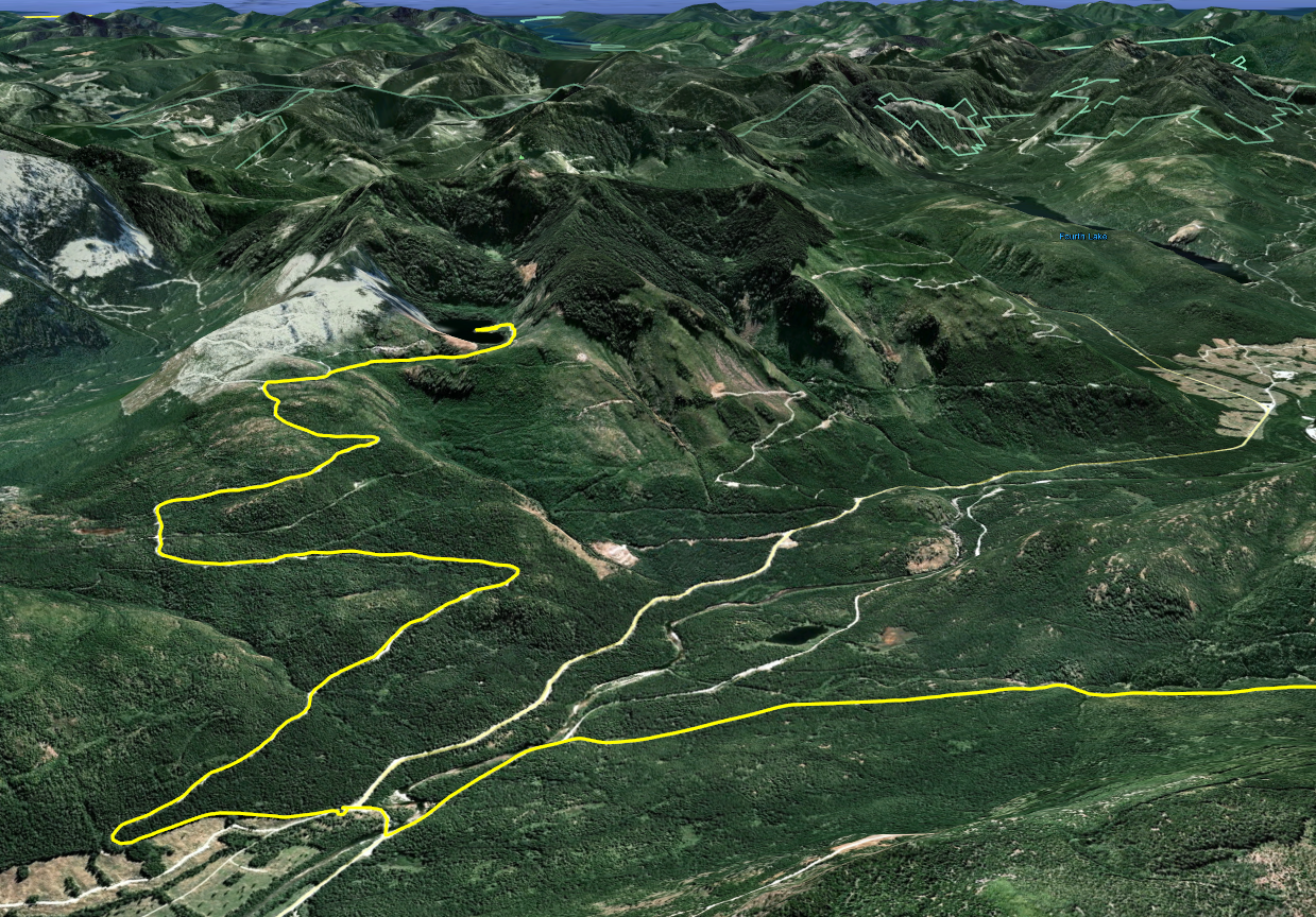
We needed a short local ride today to seat Paul's brand spanking new D606 rear tire.  What better than a quick ride up and over Blackjack Ridge to get the job done.

Here's what we did:


1.  Entered at Doumont Road
2.  Through the Tank Traps and a left turn towards Boomerang Lake
3.  Left again towards southern end of Boomerang
4.  Past S. end of Boomerang and then straight along the N.E. side of Blackjack Ridge towards Lucid Lk.
5.  Right turn after Lucid Lake
6.  Climb up creekbed towards top of Blackjack
7.  Explored dead end spur
8.  Through open gate at the top and explored dead end logging road to our right
9.  Right turn onto untried route (went straight on previous trip up here)
10.  Downhill creek bed for a fair way here.  (approx 3km)
11.  Rotten log make-shift bridge (Hurry before it's all gone)
12.  Left turn at the main logging road
13.  Return on same route to Doumont Rd.

Photos:

The descending creek bed at #10.  We walked this for a short distance before deciding to go on.

The makeshift bridge of half-rotten logs at #11. 

Other "Real Motorcycle Diaries" blog entries containing search criteria "blackjack."  (There are some better Blackjack shots in these entries).

Here's today's GPS track on video.  Realtime x100.  (Best viewed at 700p/full screen). 


Fun ride, but only once so you can say you did.  It's not horrendously difficult, it's just slow going for much of it when going through old creek beds.  My clutch wasn't very happy.  :)  Likely quite slippery in the winter!

Monday, October 08, 2012

Deadhorse Creek Gold Mine

Holy cow... No blog updates for a while now!  This one was such a great ride it must be recorded.  Paul and I have been waiting to do this ride for quite some time.  I found reference to a gold mine for sale in the Mt. DeCosmos area towards the end of the riding season last year.  Now that we have found a tried and true route into the Nanaimo Lakes region without having to use a gate, we decided the time was finally right to go and find this mine.  Actually we attempted to get there a week earlier following trails along the north side of Decosmos from the power lines, but the trail didn't look too friendly.  We walked it and managed to reach the DeCosmos road and we quite likely could have got the bikes through the rocky trail, but we just didn't welcome the struggle.  So, on Sept 29th we made our way through the standard Moriarty Lake route using what we have come to call "the key trail."

Here's our route to #19 (the mine) and back to the starting point at Doumont Rd:


 1.  Stopped and watched some amazing young riders flying over the track at the Nanaimo Motocross Assoc. (Wastelands).  Very skillful riders on that track.  We met up with Ryan there, who was able to join us on his 450 KTM.  VERY nice bike!
2.  Through the tank traps.
3.  Left turn on Branch 142 towards Boomerang Lake.
4.  Past Boomerang Lake, turned right and then right again towards the power lines route.
5.  Headed NW along the power lines.
6.  Right turn to follow Okay Mountain Valley, (on west side of mountain).
7.  Left onto 155 main.  Got to try Ryan's KTM here... WOW!
8.  Turned left off of 155 towards mountain ridge NE of Moriarty Mountain onto 155N.
9.  Left turn towards mountain ridge.
10.  Ridge Trail NE of Mt. Moriarty
11.  Turned right onto "key trail" linking the northern logging roads to the southern roads (thanks Google E).  There's a nasty downhill section full of young alders shortly after this location.  (Might not be easily accessible if quaders don't hurry up and help us in keeping the trail usable).
12.  Down through alders.
13.  Left turn towards Healy Lake.  This was a failed attempt to get through to the DeCosmos roads by cutting past Healy Lk. 
14.  We stopped briefly at the lake to take a look:  Catch and release with non-barbed hooks here.  Daily limit=0. 
15.  Past the lake it began to get pretty steep and rocky.  Too rich for my blood!  Ryan had little trouble blasting through this section on his KTM, but Paul and I would have had much greater difficulty.  Do-able I think, but not without pushing and pulling each other.  :(  Much easier to continue through Nanaimo River Road.
16.  Back onto the main trail and downhill to Nanaimo River Road.
17.  Left turn at the beginning of Second Lake to follow the road leading up Mt. DeCosmos.
18.  Right turn onto mine trail and a sharp left again up a well grown in trail that begins to climb a bit steeper.

19.  We reached the Deadhorse Creek Gold Mine.  The narrow trail comes to an abrupt end where it meets the creek.  You can see the mine opening from here if you look slightly upwards at about 2 o'clock.  You need to climb down into the creek bed, which is about 15ft below you.  Someone has very kindly attached a couple of ropes to a tree to help you climb down about ten feet.  Once down, the entrance is clearly visible to your right and easy to reach.  (It has a flat roof, which I found a bit surprising).  We entered the mine for about 50m and encountered a vertical ventilation shaft that lets a good deal of light in.  From here there are a couple of spurs leading off in different directions.

We discovered that Paul had acquired a large metal staple in his rear tire.  It was pretty clear that a gentle ride out would be the best fix.  Excellent bit of riding on his part, not only in protecting the rim from damage, but staying upright on a tire with broken beads down a pretty bumpy trail.

20.  Luckily, the yellow gate was opened by a truck ahead of us and we escaped through without needing to retrace our route heading north.  We turned left shortly after the main gate and continued towards Doumont on logging roads once more.
21.  Continued along the SW side of Blackjack Ridge.
22.  Right towards Boomerang Lake.
23.  Thru the Tank Traps and out to Doumont to put Paul's sick bike onto Ryan's truck.  ;)

Here's some photos:

Healy Lake

Parked at Healy Lake
 
The end of the trail leading up to Deadhorse Creek.  You gotta wonder how that staple managed to get up there.  Surely nobody would be stupid enough to keep riders away from looking at a mine by puncturing their tires? 
 
Climbing down into the creek bed

Climbing down using the ropes.  You can see the entrance to the mine in this shot:  Look at the tree on the right.  Now look between the two sets of main branches on the left side of this tree.  The darker spot in the gap between is the mine opening.

You can see the mine entrance a little clearer here.  Ryan is pointing his camera directly at it.  I'm standing at the bottom of the ropes where we climbed down.


The mine entrance, (lit by daylight).  Square!?  I thought rounded would have been stronger/safer.  What do I know?
    
In the mine.  Looking back towards the entrance.

Looking up.  This is a vertical shaft about 50m into the mine.  Pretty wet here...  Lots of water dripping into the mine from this spot.  There were a couple of rotting timbers that appeared to be carrying some load at this location.  Good time to watch your step a bit more carefully.  Tons of ventilation happening... No worries about gasses, although I guess that's more of a coal mine problem.

Oh, another shot of the entrance, like it's any different when you're on the way out.

Ryan at the entrance and Paul further back making ridiculous "scary faces" with his little Walmart flashlight.

Detail view of the road past Healy Lk. where we turned back.

Detail view of the DeCosmos road that begins left, right before Second Lake.  The top shows the right turn onto the mine road and the following left turn up towards the mine.
Outstanding ride!  Highly recommended!

(Updated route to this mine with a downloadable track can be found here).

Thursday, August 30, 2012

Off to Heart Lake ❤

Last winter Paul blogged about a route to Heart Lake that he was keen on trying.  Heart Lake is situated at an approx altitude of 860m on the eastern side of Green Mountain, about 30km SW of downtown Nanaimo.  Yesterday Paul, Sebastian and I headed out to find Heart Lake on what is becoming a standard route for us:


1.  Began at Doumont Road and went through the tank traps before turning left.
2.  Travelled over the new bridge...  No new yellow gate :)
3.  Turned right at Boomerang Lake's southern intersection.
4.  Followed power lines trail. (Many improvements have been made to the roads here... The loggers may be busy soon).
5.  Turned right off of power lines route onto Okay Mt. valley road.
6.  Turned left onto 155 Main.
7.  Turned left onto 155N.
8.  Travelled up the ridge road. (It was cloudy and rainy today... No views of Mt. Moriarty).

Blueberries on the ridge road

9.  Went through the "key trail" and turned left onto a possible alternative to having to descend through the alders as we usually do on this road.
10.  Fought our way through heavy young alder growth. (It was heavier than the standard route).

mossy road surface on the "alders alternative" road before we encountered heavier alders

Paul reaches a clearing along the "alders alternative"
Sebastian emerges through the alders
11.  We stopped the bikes and walked to check the route.  We didn't walk all the way, although we went far into the overgrown road.  Not a good route without a chainsaw.  If you're a quad rider, please head up here with all your quader friends and stomp all over the alders.
12.  After deciding that the trees were too thick we retraced our steps and followed the usual road through the alders towards Nanaimo River Road.

those alders will grab onto anything from front brake levers to cameras
13.  Over the bridge and left towards Heart Lake.  (A small trail to the left of the gate appears to have been provided by the logging company for small vehicles to pass through).

(top left to bottom right)  A small trail left of gate provides access.   It's difficult to see the road you need to follow when looking on Google Earth.  Follow an immediate fork to the right after the gate.  Both forks head to the lake although the right fork is more direct.
 
14.  Uphill road to Heart Lake.  It's a steep but fairly easy ride.  There are many drainage ditches on this road that keep your speed in check.

climbing up towards the lake


15.  Heart Lake at near 900m.  Beautiful lake with a depressing "grapple-yarded" mess of logs and stumps on the far shore.  What a terrible mess these people have made of one of our beautiful lake areas!  :(  Surely there are other spots you could have logged.

approaching the lake

290° stitched panoramic from the western shore of Heart Lake
good fishing cliffs on western shore

There are a number of good fishing spots on the road side of the lake.  Some spots are off of low cliffs while others can be found nearer to the water level.  We fished for a little over an hour today, (I think), and we saw very little action.  Eventually we walked out with three fish between us.  We saw a bear on the far side, which helped to make things more interesting.  (Unfortunately, the bear was looking for trees and had less luck than us).

One of us took a spill on the way out.  No large injuries luckily...  Just an improved healthy respect for downhill logging roads with ditches.  ;)  Lesson learned!

It was a terrific ride and it appears that we all really enjoyed it except for the spill. 

Here's our route spelled out on my GPS map at 100x real time.  (If you increase the resolution at the bottom right of the window, you can read the writing without squinting). :)


Friday, August 24, 2012

Back to Marcus Lake

Paul and I took another overnight trip to Marcus lake a few days ago:


1.  entered from the Doumont Road entrance
2.  through the "tank traps" and stopped by bridge construction
3.  returned and took alternate route to bypass "tank traps"  (walked bike down steep bit like a big baby)
4.  up branch 142 to 155 Main
5.  left onto 155N and over ridge overlooking Mt. Moriarty
6.  through small joiner trail giving access to roads heading south to N. River Road.
7.  over the bridge leading to Fourth Lake
8.  descending through mountain pass
9.  stopped at a wider section of the Nitinat River (actually on return trip)
10.  stopped at Nitinat River bridge (searching for, but not finding, Tuck Lake on day 2)
11.  camping/fishing at Marcus Lake

A wider section of the Nitinat River (location #9)

The logging company's ridiculous trench digging, offering a greater challenge to recreational riders.  I guess it keeps the trucks out or something.  (#9)
Beautiful section of the Nitinat River near bridge at location #10
Nitinat River bridge (#10)

Great fishing at Marcus Lake, at least for Paul who limited out on both days.  It was clearly very exciting for him!  I managed to catch a couple.  The trout have taken on a really interesting colour in this lake:  Many are darker and display a thick red line along their sides.  A few had a distinct copperish tone running their entire length...  I thought it was interesting that Paul's lure copied this colouration quite closely.  (I'm not sure if he agrees on this).  He was using a small copper lure with a red flash.  Must get one for this lake!  Cannibalistic little @%#&'s they are! 

Very dusty on the roads riding in the rear.  I ended up trailing far behind for much of the riding, more to improve my view of the road surface than to reduce dust in my filter:  It's irritating as hell hitting deep potholes that appear through the dust under your front tire.  With that said, it was a terrific ride...  I love the route though the pass below Fourth Lake.  I can't believe it took us so long to start using this road.

Tuesday, August 14, 2012

Riding Over Okay Mountain from the S.E..... Almost!

We had an interesting ride yesterday.  Sebastian had been plotting a route from Errington to Doumont that went over the top of Okay Mountain.  Having tried part of the route before and having been stopped by snow and a steep climb up Okay, it seemed to make more sense to attack this route from the Doumont side:  The steeper rocky section would be easier to ride down coming from the S.E.  Now we just had to find out if the trails marked on Sebastian's route were rideable.

Here's the original route plan (right to left):


We ran into difficulty right off the bat:  What looked like an old logging road heading SW up Okay Mountain turned out to be a creek bed that joins with a more obvious old logging road further up the mountain.  Our plan changed to one of pure exploration:  Is there a road or trail that will take you up or around the mountain from that side?  We began riding any spur trail we could find.  In the end, we nearly did it.  We almost got through to clear trails on the other side of the mountain, except for 150m of non-rideable walking trails!

Here's the actual route we ended up taking:

  
 Some of these roads were increadibly grown-in and we spent quite a bit of time stopping to remove fallen trees and clearing debris.  Great fun, but HOT as hell!

  
Location "A."  We followed yellow ribbons to get here.  There was an old trail, but it eventually became impossible to go further with the bikes.  We walked on for about 100m to a clearing which had great views of the valley running up to Rhododendron Lake.
Location "A."  Turning around.
Location "B" was a short dead-end spur.  At this point we were exploring anything that made its way towards the mountain.

Location "C" was another dead-end spur, but this time it was a new active road that looks like it may go further into the bush in the near future.
Location "D."  The end of an older trail with plenty of new alder growth throughout.  It petered out shortly beyond this point.
We decided to give the usual road that leads to the top another try.  I got stopped by snow going up here last winter and Paul had stopped some distance beyond by a large rocky area.  Sebastian and I made it past the snow location, but the steeper rocky section beyond had us turning around pretty soon after, (at location "E").   We had hoped to come down this section today, but clearly there's no way up there from the other side.

Location "F."  Stopped again.  This was a real bummer!  We moved quite a few obstacles to get this far along, but the road was impossible to ride after this point.  Oddly enough, a walking trail is clearly marked off to the right side of this photo.  We walked part of it... tough ride.  150m from here to open logging roads on the other side.  Too bad--we almost made it!
Straight ahead is the the walking trail opening at location "F."  (Sign on far right of photo). 
 So, that was it!  It wasn't what we had intended, but it turned out to be a pile of fun all the same.  We saw an interesting sight on our way back to Doumont Rd:  There are two backhoes now parked between the tank traps intersection and Boomerang Lake.  You have to wonder if they're gearing up to do some serious road blocking by digging more channels as they did right at the Weigles Rd. entrance a few weeks ago.  Hope not!  There has been a lot of dumping in the area lately!  :(

Let's hope it's just a good parking spot!
 Great ride... thanks Sebastian.

Saturday, August 04, 2012

Doumont Road to Cowichan Lake with NO GATES!

We set out today to look for a second possible route to Moriarty Lake, an alternative to our new "key trail" which allows us to get through to the Nanaimo Lakes without passing through a Timberwest gate.  We got skunked unfortunately and we were unable to find a possible joining trail that Paul had picked out on Google Earth.  We decided instead to use the standard "key trail," make our way to the Nanaimo Lakes and then push on past Fourth Lake to Cowichan Lake.  If nothing else we could check the state of the gate just past Fourth Lake.

Here's our route:

 
1.  Entered at Doumont Rd.
2.  Turned onto the 155 Main logging road
3.  Turned left off of 155 towards mountain ridge NE of Moriarty Mountain onto 155N
4.  Looking for alternative route to Moriarty Lake
5.  Shelton Lake
6.  Passed Fourth Lake turnoff to our left
7.  Mountain pass... NO GATE
8.  Paved black-top section - Logger's highway to Cowichan!
9.  Through Youbou...  Supper in Cowichan Lake & #1 highway home

So, we got past Fourth Lake and stopped at the approximate cross-over location between two local logging company's boundaries where the gate should be.  There was no gate!  We've been wondering about this gate for quite a while now, and it appears that it's nothing but a figment of my imagination.*  I had imagined there must be a gate between the two borders since they went to the bother of removing a bridge at a similar location not far from here.  I had managed to convince us all about the problem of getting around this gate that never existed.  :) 

*  Oct 27/12:  Just saw the gate position shown in an old "V. I. mapbook," so I'm not delusional after all.

We saw some really great looking logging roads in this area that we must get back and try another day.  One in particular climbs steeply towards the SE and it looks like it would have some fantastic views of the pass we were riding through.  The road through here, an "S" that makes it's descent through the mountains north of Sadie Peak, are not nearly as difficult to ride as I had imagined.  Google Earth's exaggerated 3D view makes it look like you're about to ride the Himalayas, but the road is in pretty good shape and the steeper grades are hardly noticeable.

Mountain Trail  Heading SE through the Mountain Pass
 
We eventually reached a really good black-top section of road that takes you a fair distance towards Cowichan Lake.  You can reach speeds of 80km/h if you watch carefully for the odd crater and the occasional not-so-smooth transition between gravel road and tarmac.  This great little road follows the Nitinat river and offers some terrific spots to stop and check out the view.

Smooth Black-Top Between Fourth Lk. and Cowichan Lk.
 
We passed our previous route into Marcus Lake, (although I forgot to notice the turn as we rode through).  This will definitely be the route we take next time we take off for a camping trip into that area;  it's a far better alternative than being forced to take the highway down through Youbou as we did last time.

We continued on towards the east and drove the northern shore of Cowichan Lk. through Youbou and onto the town of Cowichan Lake for supper.  "Jake's at the Lake" is a great place to eat if you're going through town.

We blasted up the highway from here.  It's a much more boring way to travel, but we were feeling pretty satisfied from our tremendous ride from Doumont to Cowichan without hitting one logging gate!

Kudos to Paul for oiling up his plugs and riding back at 100km/h so my 250 wouldn't melt.  ;)